


ventisquero el yelcho

jpbaudoin
User
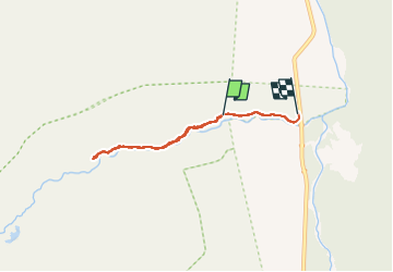

Length
5.2 km

Max alt
280 m

Uphill gradient
94 m
Km-Effort
6.6 km

Min alt
152 m

Downhill gradient
136 m
Boucle
No
Creation date :
2024-11-03 12:23:39.311
Updated on :
2024-11-03 14:12:44.229
1h45
Difficulty : Very easy

FREE GPS app for hiking
 SityTrail
IGN / Geographical institutes
SityTrail World
The world is yours!
About
Trail Walking of 5.2 km to be discovered at Los Lagos Region, Provincia de Palena, Chaitén. This trail is proposed by jpbaudoin.
Positioning
Country:
Chile
Region :
Los Lagos Region
Department/Province :
Provincia de Palena
Municipality :
Chaitén
Location:
Unknown
Start:(Dec)
Start:(UTM)
708346 ; 5205365 (18G) S.
Comments
Trails nearby