![](/images/other/stat-length.png)
![Trail Nordic walking Nivelles - Nivel./Anc. canal/Bois en Bas et du PLanti - Photo](https://media.geolcdn.com/t/1900/400/ext.pjpeg?maxdim=2&url=https%3A%2F%2Fstatic1.geolcdn.com%2Fsiteimages%2Fupload%2Ffiles%2F1545311037marcheuse_200dpi.jpg)
Nivel./Anc. canal/Bois en Bas et du PLanti
denissculier
User
![Length](/images/other/stat-length.png)
Length
8.3 km
![Max alt](https://static1.geolcdn.com/siteimages/upload/files/1508320355ic_sort_altitude_max_24dp.png)
Max alt
115 m
![Uphill gradient](https://static1.geolcdn.com/siteimages/upload/files/1508320355ic_sort_den_pos_24dp.png)
Uphill gradient
110 m
![Km-Effort](/images/other/stat-length.png)
Km-Effort
9.7 km
![Min alt](https://static1.geolcdn.com/siteimages/upload/files/1508320355ic_sort_altitude_min_24dp.png)
Min alt
68 m
![Downhill gradient](https://static1.geolcdn.com/siteimages/upload/files/1508320355ic_sort_den_neg_24dp.png)
Downhill gradient
110 m
![Boucle](https://static1.geolcdn.com/siteimages/upload/files/16400158638029165_repeat_loop_refresh_sync_direction_icon.png)
Boucle
Yes
Creation date :
2018-02-09 00:00:00.0
Updated on :
2018-02-09 00:00:00.0
![Nordic walking](https://static1.geolcdn.com/sitytour/trail-icons/102.png)
2h07
Difficulty : Medium
![Scan this QR Code to open this trail in the SityTrail application](https://capi.geolives.com/qq0zvz2zws4bq2lad0pu/sitytour/trails/423455/qr.png?size=200)
FREE GPS app for hiking
About
Trail Nordic walking of 8.3 km to be discovered at Wallonia, Walloon Brabant, Nivelles. This trail is proposed by denissculier.
Description
ATTENTION - Passerelle sur la Thines impraticable - ATTENTION. Tracer ter, différents car au chemin de Hiernoulet on biffure à droite pour rejoindre le bois du Planti que l'on traverse pour enfin rejoindre le Ravel.
Positioning
Country:
Belgium
Region :
Wallonia
Department/Province :
Walloon Brabant
Municipality :
Nivelles
Location:
Monstreux
Start:(Dec)
Start:(UTM)
591257 ; 5604815 (31U) N.
Comments
Trails nearby
![Trail Walking Nivelles - RB-Bw-16_Monstreux_via-racc-1 - Photo](https://media.geolcdn.com/t/375/260/ext.jpg?maxdim=2&url=https%3A%2F%2Fservices.sitytrail.com%2FGeolivesWS%2FDownloadMedia.ashx%3FTrailID%3D354126%26Media%3Ddaedf7ee-f25e-4941-815b-dbbb8c629e47.jpg)
![Walking Walking](https://static1.geolcdn.com/sitytour/trail-icons/101.png)
RB-Bw-16_Monstreux_via-racc-1
Walking
Difficult
(11)
Nivelles,
Wallonia,
Walloon Brabant,
Belgium
![](/images/other/stat-length.png)
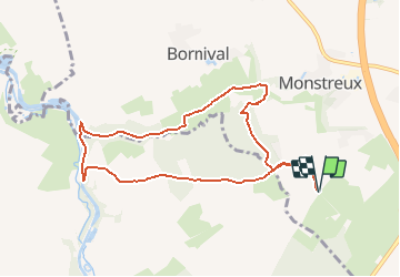
12.8 km | 15 km-effort
3h 24min
![](https://static1.geolcdn.com/siteimages/upload/files/16400158638029165_repeat_loop_refresh_sync_direction_icon.png)
Yes
![Trail Walking Nivelles - RB-BW-16 - Raccourci 1 - Par monts et canaux, de part et d’autre de la Thines - Photo](https://media.geolcdn.com/t/375/260/ext.jpg?maxdim=2&url=https%3A%2F%2Fservices.sitytrail.com%2FGeolivesWS%2FDownloadMedia.ashx%3FTrailID%3D221718%26Media%3Ddaedf7ee-f25e-4941-815b-dbbb8c629e47.jpg)
![Walking Walking](https://static1.geolcdn.com/sitytour/trail-icons/101.png)
RB-BW-16 - Raccourci 1 - Par monts et canaux, de part et d’autre de la Thines
Walking
Difficult
(9)
Nivelles,
Wallonia,
Walloon Brabant,
Belgium
![](/images/other/stat-length.png)
16 km | 18.9 km-effort
4h 17min
![](https://static1.geolcdn.com/siteimages/upload/files/16400158638029165_repeat_loop_refresh_sync_direction_icon.png)
Yes
![Trail Walking Nivelles - RB-Bw-16_Monstreux - Photo](https://media.geolcdn.com/t/375/260/ext.jpg?maxdim=2&url=https%3A%2F%2Fservices.sitytrail.com%2FGeolivesWS%2FDownloadMedia.ashx%3FTrailID%3D179591%26Media%3D606a627b-9c11-4c95-a0ed-8415395e822e.jpg)
![Walking Walking](https://static1.geolcdn.com/sitytour/trail-icons/101.png)
RB-Bw-16_Monstreux
Walking
Very difficult
(11)
Nivelles,
Wallonia,
Walloon Brabant,
Belgium
![](/images/other/stat-length.png)
20 km | 24 km-effort
5h 24min
![](https://static1.geolcdn.com/siteimages/upload/files/16400158638029165_repeat_loop_refresh_sync_direction_icon.png)
Yes
![Trail Walking Seneffe - De Arquennes à Monstreux par les vallées de la Thines et de la Samme - Photo](https://media.geolcdn.com/t/375/260/ext.jpg?maxdim=2&url=https%3A%2F%2Fservices.sitytrail.com%2FGeolivesWS%2FDownloadMedia.ashx%3FTrailID%3D127787%26Media%3D79b12576-f9f5-4657-a448-2793aa9c7eb2.JPG)
![Walking Walking](https://static1.geolcdn.com/sitytour/trail-icons/101.png)
De Arquennes à Monstreux par les vallées de la Thines et de la Samme
Walking
Easy
(6)
Seneffe,
Wallonia,
Hainaut,
Belgium
![](/images/other/stat-length.png)
13.7 km | 15.4 km-effort
3h 30min
![](https://static1.geolcdn.com/siteimages/upload/files/16400158638029165_repeat_loop_refresh_sync_direction_icon.png)
Yes
![Trail Walking Braine-le-Comte - De Ronquieres vers Fauquez par le bois des Rocs et de la Houssi�re - Photo](https://media.geolcdn.com/t/375/260/ext.jpg?maxdim=2&url=https%3A%2F%2Fstatic1.geolcdn.com%2Fsiteimages%2Fupload%2Ffiles%2F1553511878bg_sport_marche.png)
![Walking Walking](https://static1.geolcdn.com/sitytour/trail-icons/101.png)
De Ronquieres vers Fauquez par le bois des Rocs et de la Houssi�re
Walking
Easy
(9)
Braine-le-Comte,
Wallonia,
Hainaut,
Belgium
![](/images/other/stat-length.png)
8.2 km | 10.5 km-effort
2h 5min
![](https://static1.geolcdn.com/siteimages/upload/files/16400158638029165_repeat_loop_refresh_sync_direction_icon.png)
Yes
![Trail Walking Nivelles - Rando Bornival - Photo](https://media.geolcdn.com/t/375/260/ext.jpg?maxdim=2&url=https%3A%2F%2Fstatic1.geolcdn.com%2Fsiteimages%2Fupload%2Ffiles%2F1553511878bg_sport_marche.png)
![Walking Walking](https://static1.geolcdn.com/sitytour/trail-icons/101.png)
Rando Bornival
Walking
Easy
(5)
Nivelles,
Wallonia,
Walloon Brabant,
Belgium
![](/images/other/stat-length.png)
13.2 km | 15.9 km-effort
3h 27min
![](https://static1.geolcdn.com/siteimages/upload/files/16400158638029165_repeat_loop_refresh_sync_direction_icon.png)
Yes
![Walking Walking](https://static1.geolcdn.com/sitytour/trail-icons/101.png)
BE-Bornival - Bois d'En-Bas - Ecluse 24 - Ancien canal
Walking
Medium
(3)
Nivelles,
Wallonia,
Walloon Brabant,
Belgium
![](/images/other/stat-length.png)
6.3 km | 7.5 km-effort
1h 41min
![](https://static1.geolcdn.com/siteimages/upload/files/16400158638029165_repeat_loop_refresh_sync_direction_icon.png)
Yes
![Trail Walking Seneffe - RB-HA-05 - Raccourci - Autour de la tour de Ronquières - Photo](https://media.geolcdn.com/t/375/260/ext.jpg?maxdim=2&url=https%3A%2F%2Fservices.sitytrail.com%2FGeolivesWS%2FDownloadMedia.ashx%3FTrailID%3D217842%26Media%3D989f0d00-0244-4058-a77e-e5e5f489d7be.jpg)
![Walking Walking](https://static1.geolcdn.com/sitytour/trail-icons/101.png)
RB-HA-05 - Raccourci - Autour de la tour de Ronquières
Walking
Very difficult
(4)
Seneffe,
Wallonia,
Hainaut,
Belgium
![](/images/other/stat-length.png)
23 km | 26 km-effort
5h 58min
![](https://static1.geolcdn.com/siteimages/upload/files/16400158638029165_repeat_loop_refresh_sync_direction_icon.png)
Yes
![Trail Walking Seneffe - RB-HA-05 - Autour de la tour de Ronquières - Photo](https://media.geolcdn.com/t/375/260/ext.jpg?maxdim=2&url=https%3A%2F%2Fservices.sitytrail.com%2FGeolivesWS%2FDownloadMedia.ashx%3FTrailID%3D179598%26Media%3D989f0d00-0244-4058-a77e-e5e5f489d7be.jpg)
![Walking Walking](https://static1.geolcdn.com/sitytour/trail-icons/101.png)
RB-HA-05 - Autour de la tour de Ronquières
Walking
Very difficult
(3)
Seneffe,
Wallonia,
Hainaut,
Belgium
![](/images/other/stat-length.png)
22 km | 25 km-effort
5h 39min
![](https://static1.geolcdn.com/siteimages/upload/files/16400158638029165_repeat_loop_refresh_sync_direction_icon.png)
Yes