![](/images/other/stat-length.png)
![Trail Walking Aubel - Abbaye du Val-Dieu - Photo](https://media.geolcdn.com/t/1900/400/9d88fb8b-e71a-44b2-8c92-c3e63b97e3bd.jpg&format=pjpeg&maxdim=2)
Abbaye du Val-Dieu
Je vous emmène sur mes chemins
Par Mumu.larandonneuse
![Length](/images/other/stat-length.png)
Length
7.8 km
![Max alt](https://static1.geolcdn.com/siteimages/upload/files/1508320355ic_sort_altitude_max_24dp.png)
Max alt
215 m
![Uphill gradient](https://static1.geolcdn.com/siteimages/upload/files/1508320355ic_sort_den_pos_24dp.png)
Uphill gradient
145 m
![Km-Effort](/images/other/stat-length.png)
Km-Effort
9.8 km
![Min alt](https://static1.geolcdn.com/siteimages/upload/files/1508320355ic_sort_altitude_min_24dp.png)
Min alt
142 m
![Downhill gradient](https://static1.geolcdn.com/siteimages/upload/files/1508320355ic_sort_den_neg_24dp.png)
Downhill gradient
144 m
![Boucle](https://static1.geolcdn.com/siteimages/upload/files/16400158638029165_repeat_loop_refresh_sync_direction_icon.png)
Boucle
Yes
Creation date :
2024-10-23 09:18:34.145
Updated on :
2024-10-23 13:05:00.847
![Walking](https://static1.geolcdn.com/sitytour/trail-icons/101.png)
1h56
Difficulty : Medium
![Scan this QR Code to open this trail in the SityTrail application](https://capi.geolives.com/qq0zvz2zws4bq2lad0pu/sitytour/trails/4234157/qr.png?size=200)
FREE GPS app for hiking
About
Trail Walking of 7.8 km to be discovered at Wallonia, Liège, Aubel. This trail is proposed by Je vous emmène sur mes chemins .
Description
Un mélange de plusieurs balisages.
👣 Prairies, échaliers, sentiers, chemins et routes.
Positioning
Country:
Belgium
Region :
Wallonia
Department/Province :
Liège
Municipality :
Aubel
Location:
Unknown
Start:(Dec)
Start:(UTM)
698038 ; 5620018 (31U) N.
Comments
Trails nearby
![Trail Walking Aubel - autour de val dieu - Photo](https://media.geolcdn.com/t/375/260/fd89e5f6-352d-4ec8-ac99-e9175fe8e322.jpg&format=jpg&maxdim=2)
![Walking Walking](https://static1.geolcdn.com/sitytour/trail-icons/101.png)
autour de val dieu
Walking
Very easy
(6)
Aubel,
Wallonia,
Liège,
Belgium
![](/images/other/stat-length.png)
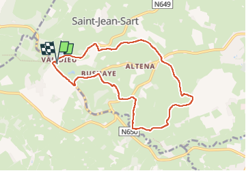
9.5 km | 12.1 km-effort
2h 13min
![](https://static1.geolcdn.com/siteimages/upload/files/16400158638029165_repeat_loop_refresh_sync_direction_icon.png)
Yes
![Trail Walking Herve - Entre bois et GR (8km) - Photo](https://media.geolcdn.com/t/375/260/ext.jpg?maxdim=2&url=https%3A%2F%2Fstatic1.geolcdn.com%2Fsiteimages%2Fupload%2Ffiles%2F1553511878bg_sport_marche.png)
![Walking Walking](https://static1.geolcdn.com/sitytour/trail-icons/101.png)
Entre bois et GR (8km)
Walking
Very easy
(5)
Herve,
Wallonia,
Liège,
Belgium
![](/images/other/stat-length.png)
7.7 km | 10.1 km-effort
Unknown
![](https://static1.geolcdn.com/siteimages/upload/files/16400158638029165_repeat_loop_refresh_sync_direction_icon.png)
Yes
![Trail Walking Thimister-Clermont - La Minerie - Photo](https://media.geolcdn.com/t/375/260/ext.jpg?maxdim=2&url=https%3A%2F%2Fstatic1.geolcdn.com%2Fsiteimages%2Fupload%2Ffiles%2F1553511878bg_sport_marche.png)
![Walking Walking](https://static1.geolcdn.com/sitytour/trail-icons/101.png)
La Minerie
Walking
Easy
(6)
Thimister-Clermont,
Wallonia,
Liège,
Belgium
![](/images/other/stat-length.png)
12.9 km | 15.7 km-effort
3h 22min
![](https://static1.geolcdn.com/siteimages/upload/files/16400158638029165_repeat_loop_refresh_sync_direction_icon.png)
Yes
![Trail Walking Thimister-Clermont - Froidthier - Photo](https://media.geolcdn.com/t/375/260/9142f7fe-feb5-4533-8005-65992f1c4338.jpg&format=jpg&maxdim=2)
![Walking Walking](https://static1.geolcdn.com/sitytour/trail-icons/101.png)
Froidthier
Walking
Easy
(1)
Thimister-Clermont,
Wallonia,
Liège,
Belgium
![](/images/other/stat-length.png)
6.6 km | 7.9 km-effort
1h 48min
![](https://static1.geolcdn.com/siteimages/upload/files/16400158638029165_repeat_loop_refresh_sync_direction_icon.png)
Yes
![Trail Walking Voeren - La Commanderie 7 - Photo](https://media.geolcdn.com/t/375/260/e2b67305-0779-4cca-9070-82e3402cc790.jpg&format=jpg&maxdim=2)
![Walking Walking](https://static1.geolcdn.com/sitytour/trail-icons/101.png)
La Commanderie 7
Walking
Easy
(1)
Voeren,
Flanders,
Limburg,
Belgium
![](/images/other/stat-length.png)
4.5 km | 6.3 km-effort
1h 26min
![](https://static1.geolcdn.com/siteimages/upload/files/16400158638029165_repeat_loop_refresh_sync_direction_icon.png)
Yes
![Trail Walking Dalhem - 2021-10-21_18h00m54_1397 - Photo](https://media.geolcdn.com/t/375/260/9e5bb66b-83f0-45b1-bd6f-be4253f11322.jpg&format=jpg&maxdim=2)
![Walking Walking](https://static1.geolcdn.com/sitytour/trail-icons/101.png)
2021-10-21_18h00m54_1397
Walking
Medium
(2)
Dalhem,
Wallonia,
Liège,
Belgium
![](/images/other/stat-length.png)
13.9 km | 17.6 km-effort
3h 59min
![](https://static1.geolcdn.com/siteimages/upload/files/16400158638029165_repeat_loop_refresh_sync_direction_icon.png)
Yes
![Trail Walking Thimister-Clermont - 2021-03-21_09h09m37_1413 - Photo](https://media.geolcdn.com/t/375/260/2cdc1fed-57d0-4e96-9f7c-8bfb9eab2451.jpg&format=jpg&maxdim=2)
![Walking Walking](https://static1.geolcdn.com/sitytour/trail-icons/101.png)
2021-03-21_09h09m37_1413
Walking
Easy
(2)
Thimister-Clermont,
Wallonia,
Liège,
Belgium
![](/images/other/stat-length.png)
11.1 km | 13.6 km-effort
3h 5min
![](https://static1.geolcdn.com/siteimages/upload/files/16400158638029165_repeat_loop_refresh_sync_direction_icon.png)
Yes
![Trail Walking Herve - 2021-02-28_19h05m57_1156 (1) - Photo](https://media.geolcdn.com/t/375/260/397fd954-e4c5-479f-b08e-d81a79215105.jpg&format=jpg&maxdim=2)
![Walking Walking](https://static1.geolcdn.com/sitytour/trail-icons/101.png)
2021-02-28_19h05m57_1156 (1)
Walking
Very difficult
(1)
Herve,
Wallonia,
Liège,
Belgium
![](/images/other/stat-length.png)
16.4 km | 21 km-effort
4h 47min
![](https://static1.geolcdn.com/siteimages/upload/files/16400158638029165_repeat_loop_refresh_sync_direction_icon.png)
Yes
![Trail Walking Blegny - Mortier - Photo](https://media.geolcdn.com/t/375/260/8ae971b0-94ee-4292-831a-4bed9649b36e.jpg&format=jpg&maxdim=2)
![Walking Walking](https://static1.geolcdn.com/sitytour/trail-icons/101.png)