Trail Walking Saint-Hippolyte - Hippolyte  - Photo
© OpenStreetMap contributors
Length
Length
11.8 km
Max alt
Max alt
734 m
Uphill gradient
Uphill gradient
437 m
Km-Effort
Km-Effort  
17.6 km
Min alt
Min alt
381 m
Downhill gradient
Downhill gradient
436 m
Boucle
Boucle
Yes
Creation date :
2024-10-15 07:16:20.261
Updated on :
2024-10-17 18:59:21.997

(0 Reviews)

Walking
Walking
2h57
Difficulty : Easy

Scan this QR Code to open this trail in the SityTrail application

FREE GPS app for hiking

Logo SityTrail SityTrail

IGN / Geographical institutes

Download SityTrail from the App Store Download SityTrail from Google Play

Logo SityTrail SityTrail World

The world is yours!

Download SityTrail from the App Store Download SityTrail from Google Play Download SityTrail on Huawei AppGallery

About

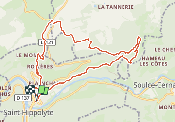
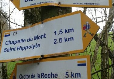
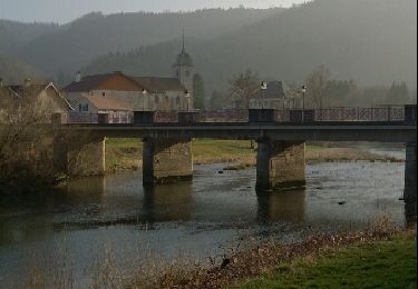
Trail Walking of 11.8 km to be discovered at Bourgogne-Franche-Comté, Doubs, Saint-Hippolyte. This trail is proposed by eltonnermou.

Description

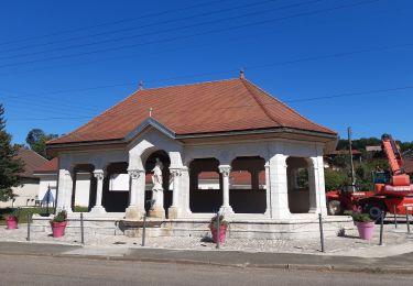
parking près de l'école, du colruyt.
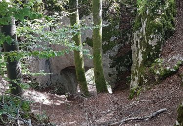
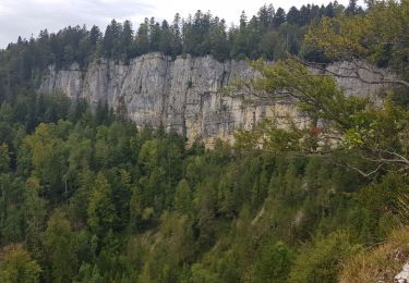
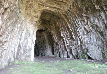
très belle randonnée essentiellement en de magnifiques sous bois, avec des beaux points de vue. Le départ se fait par une montée assez engageante (bâtons fortement conseillés), vite oubliée avec la beauté de la nature. Vous croiserez une très belle cascade, puis un dôme de tuf, de quoi égayer vos pupilles.
Et comme dans de tels paysages, laissez vous surprendre, comme moi par des chamois et un écureuil , par la faune et la flore, sans toutefois la cueillir.

Elevation profile

Photos

31 photos in total. Please click on a photo to see them all in the gallery.

Positioning

Country:
France
Region :
Bourgogne-Franche-Comté
Department/Province :
Doubs
Municipality :
Saint-Hippolyte
Location:
Unknown
Start:(UTM)
334887 ; 5243059 (32T) N.

Trails nearby

Trail Walking Saint-Hippolyte - St Hippolyte - Grotte du Château de la Roche - Grotte du Bisontin - Photo
Walking
Bart2015

Walking

Medium
Saint-Hippolyte, Bourgogne-Franche-Comté, Doubs, France
14.5 km | 22 km-effort
3h 8min
Yes
Trail Walking Montécheroux - grotte du Bisontin depuis Montécheroux - Photo
Walking
margotte

Walking

Easy
Montécheroux, Bourgogne-Franche-Comté, Doubs, France
10.6 km | 14.8 km-effort
3h 12min
Yes
Trail Walking Noirefontaine - oeil de boeuf - Photo
Walking
klopbill

Walking

Medium
(1)
Noirefontaine, Bourgogne-Franche-Comté, Doubs, France
12.4 km | 17 km-effort
3h 50min
Yes
Trail Walking Saint-Hippolyte - GTJ jour1 - Photo
Walking
werth

Walking

Difficult
Saint-Hippolyte, Bourgogne-Franche-Comté, Doubs, France
18.6 km | 28 km-effort
7h 38min
No
Trail Mountain bike Saint-Hippolyte - j2 jura - Photo
Mountain bike
Thierry Lalouze

Mountain bike

Difficult
Saint-Hippolyte, Bourgogne-Franche-Comté, Doubs, France
51 km | 74 km-effort
4h 23min
No
Trail Walking Saint-Hippolyte - Étape 3 : St Hippolyte à Fessevillers - Photo
Walking
annefrance70

Walking

Difficult
Saint-Hippolyte, Bourgogne-Franche-Comté, Doubs, France
18.3 km | 28 km-effort
6h 58min
No
Trail Walking Villars-lès-Blamont - Sappois  - Photo
Walking
juliogomez

Walking

Medium
Villars-lès-Blamont, Bourgogne-Franche-Comté, Doubs, France
15.7 km | 23 km-effort
5h 15min
Yes
Trail Running Chamesol - grotte du château des roches - Photo
Running
ebihr4

Running

Easy
Chamesol, Bourgogne-Franche-Comté, Doubs, France
9.1 km | 14.2 km-effort
2h 57min
Yes
Trail Walking Soulce-Cernay - la grotte - Photo
Walking
banzai25200

Walking

Medium
Soulce-Cernay, Bourgogne-Franche-Comté, Doubs, France
6.6 km | 11.1 km-effort
2h 24min
Yes


Close
My subscriptions