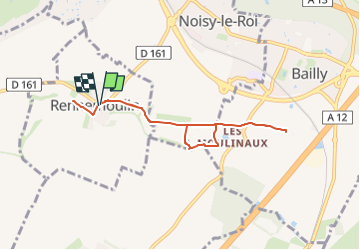
![](/images/other/stat-length.png)
2024-11-12-Rennemoulin-fontaine de Maltoute
Rando MLC
User
![Length](/images/other/stat-length.png)
![Max alt](https://static1.geolcdn.com/siteimages/upload/files/1508320355ic_sort_altitude_max_24dp.png)
![Uphill gradient](https://static1.geolcdn.com/siteimages/upload/files/1508320355ic_sort_den_pos_24dp.png)
![Km-Effort](/images/other/stat-length.png)
![Min alt](https://static1.geolcdn.com/siteimages/upload/files/1508320355ic_sort_altitude_min_24dp.png)
![Downhill gradient](https://static1.geolcdn.com/siteimages/upload/files/1508320355ic_sort_den_neg_24dp.png)
![Boucle](https://static1.geolcdn.com/siteimages/upload/files/16400158638029165_repeat_loop_refresh_sync_direction_icon.png)
![Walking](https://static1.geolcdn.com/sitytour/trail-icons/101.png)
1h47
Difficulty : Medium
![Scan this QR Code to open this trail in the SityTrail application](https://capi.geolives.com/qq0zvz2zws4bq2lad0pu/sitytour/trails/4225223/qr.png?size=200)
FREE GPS app for hiking
About
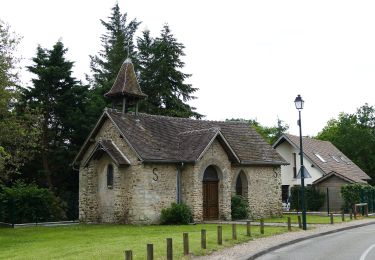
Trail Walking of 6.6 km to be discovered at Ile-de-France, Yvelines, Rennemoulin. This trail is proposed by Rando MLC.
Description
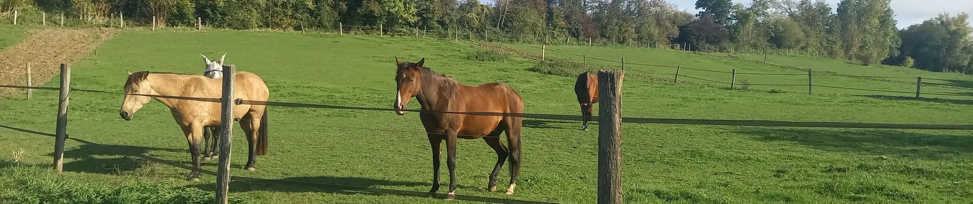
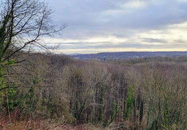
Jolie balade avec de très belles vues. Quasiment plat et grande partie sur chemin gravillonné ou empierré. Seul bémol : un quasi aller-retour. L'alternative consisterait à passer sur une route assez fréquentée, étroite et sans trottoir. Les travaux de compensation de zone humide empêchent le retour de la fontaine par le chemin plus au sud
Positioning
Comments
Trails nearby
![Trail Walking L'Étang-la-Ville - GRP CV-IDF 2023 - Photo](https://media.geolcdn.com/t/375/260/5b76ffb0-032e-4c30-9eff-c534da0117fa.jpg&format=jpg&maxdim=2)
![Walking Walking](https://static1.geolcdn.com/sitytour/trail-icons/101.png)
Walking
![](/images/other/stat-length.png)
![](https://static1.geolcdn.com/siteimages/upload/files/16400158638029165_repeat_loop_refresh_sync_direction_icon.png)
![Trail Walking Marly-le-Roi - Boucle 25 km Marly le Roi - Chambourcy - Photo](https://media.geolcdn.com/t/375/260/1fe661ec-cb67-45eb-bf71-8b90e4b33a5d.jpg&format=jpg&maxdim=2)
![Walking Walking](https://static1.geolcdn.com/sitytour/trail-icons/101.png)
Walking
![](/images/other/stat-length.png)
![](https://static1.geolcdn.com/siteimages/upload/files/16400158638029165_repeat_loop_refresh_sync_direction_icon.png)
![Trail Walking L'Étang-la-Ville - Gare de St Nom - Boucle nocturne Gr ~2h 8,5km - Photo](https://media.geolcdn.com/t/375/260/ext.jpg?maxdim=2&url=https%3A%2F%2Fstatic1.geolcdn.com%2Fsiteimages%2Fupload%2Ffiles%2F1553511878bg_sport_marche.png)
![Walking Walking](https://static1.geolcdn.com/sitytour/trail-icons/101.png)
Walking
![](/images/other/stat-length.png)
![](https://static1.geolcdn.com/siteimages/upload/files/16400158638029165_repeat_loop_refresh_sync_direction_icon.png)
![Trail On foot L'Étang-la-Ville - Le tour du Grand Paris par le GR1 Etape 2 - Saint Nom la Bretèche - Triel sur Seine - Photo](https://media.geolcdn.com/t/375/260/1683ad58-8376-4601-9416-cabd4c0df082.jpg&format=jpg&maxdim=2)
![On foot On foot](https://static1.geolcdn.com/sitytour/trail-icons/100.png)
On foot
![](/images/other/stat-length.png)
![](https://static1.geolcdn.com/siteimages/upload/files/16400158638029165_repeat_loop_refresh_sync_direction_icon.png)
![Trail Mountain bike Saint-Cyr-l'École - 14102013 - Photo](https://media.geolcdn.com/t/375/260/ext.jpg?maxdim=2&url=https%3A%2F%2Fstatic1.geolcdn.com%2Fsiteimages%2Fupload%2Ffiles%2F1524743154velo.jpg)
![Mountain bike Mountain bike](https://static1.geolcdn.com/sitytour/trail-icons/202.png)
Mountain bike
![](/images/other/stat-length.png)
![](https://static1.geolcdn.com/siteimages/upload/files/16400158638029165_repeat_loop_refresh_sync_direction_icon.png)
![Trail Walking Marly-le-Roi - 2025 02 05 Louveciennes 11 km - Photo](https://media.geolcdn.com/t/375/260/ext.jpg?maxdim=2&url=https%3A%2F%2Fstatic1.geolcdn.com%2Fsiteimages%2Fupload%2Ffiles%2F1553511878bg_sport_marche.png)
![Walking Walking](https://static1.geolcdn.com/sitytour/trail-icons/101.png)
Walking
![](/images/other/stat-length.png)
![](https://static1.geolcdn.com/siteimages/upload/files/16400158638029165_repeat_loop_refresh_sync_direction_icon.png)
![Trail Walking Versailles - Tour du grand canal - Photo](https://media.geolcdn.com/t/375/260/44f1d875-f9d9-48f9-b6e9-6bb3ee1324d4.jpg&format=jpg&maxdim=2)
![Walking Walking](https://static1.geolcdn.com/sitytour/trail-icons/101.png)
Walking
![](/images/other/stat-length.png)
![](https://static1.geolcdn.com/siteimages/upload/files/16400158638029165_repeat_loop_refresh_sync_direction_icon.png)
![Trail Walking Versailles - Pièce d'eau des Suisses - Photo](https://media.geolcdn.com/t/375/260/0fec71f6-644a-4813-86e2-a3c43307f25b.jpg&format=jpg&maxdim=2)
![Walking Walking](https://static1.geolcdn.com/sitytour/trail-icons/101.png)
Walking
![](/images/other/stat-length.png)
![](https://static1.geolcdn.com/siteimages/upload/files/16400158638029165_repeat_loop_refresh_sync_direction_icon.png)
![Trail On foot Chavenay - PR - Photo](https://media.geolcdn.com/t/375/260/f8e6bd7a-5875-409f-a50f-40b8535a7dfc.jpeg&format=jpg&maxdim=2)
![On foot On foot](https://static1.geolcdn.com/sitytour/trail-icons/100.png)