Trail Mountain bike Épeigné-les-Bois - Epeigné les bois 2015 - Photo
© OpenStreetMap contributors
Length
Length
48 km
Max alt
Max alt
145 m
Uphill gradient
Uphill gradient
621 m
Km-Effort
Km-Effort  
56 km
Min alt
Min alt
66 m
Downhill gradient
Downhill gradient
623 m
Boucle
Boucle
Yes
Creation date :
2015-05-17 00:00:00.0
Updated on :
2015-05-17 00:00:00.0

(0 Reviews)

Mountain bike
Mountain bike
3h38
Difficulty : Difficult

Scan this QR Code to open this trail in the SityTrail application

FREE GPS app for hiking

Logo SityTrail SityTrail

IGN / Geographical institutes

Download SityTrail from the App Store Download SityTrail from Google Play

Logo SityTrail SityTrail World

The world is yours!

Download SityTrail from the App Store Download SityTrail from Google Play Download SityTrail on Huawei AppGallery

About

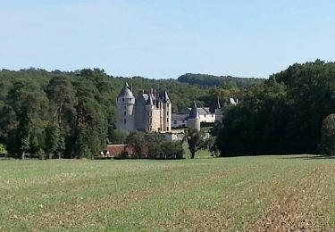
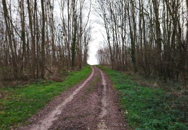
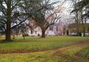
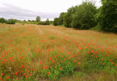
Trail Mountain bike of 48 km to be discovered at Centre-Loire Valley, Indre-et-Loire, Épeigné-les-Bois. This trail is proposed by pates_au_chaud.

Description

17-05-2015 Rando organisée

Elevation profile

Positioning

Country:
France
Region :
Centre-Loire Valley
Department/Province :
Indre-et-Loire
Municipality :
Épeigné-les-Bois
Location:
Unknown
Start:(UTM)
357191 ; 5238162 (31T) N.

Trails nearby

Trail Walking Épeigné-les-Bois - Epeigné-les-Bois - Montpoupon - 11,5km 160m 2h15mn - 2016 12 29 - Photo
Walking
GUIDE
Orcal37

Walking

Easy
(1)
Épeigné-les-Bois, Centre-Loire Valley, Indre-et-Loire, France
11.4 km | 13.7 km-effort
2h 15min
Yes
Trail Walking Luzillé - les petits gars - Photo
Walking
jeepee93

Walking

Very easy
(1)
Luzillé, Centre-Loire Valley, Indre-et-Loire, France
6.7 km | 7.3 km-effort
2h 13min
Yes
Trail Walking Francueil - Chenonceaux - GR41 Francueil - 12.7km 160m 2h45 - 2022 01 01 - Photo
Walking
GUIDE
Orcal37

Walking

Easy
Francueil, Centre-Loire Valley, Indre-et-Loire, France
12.7 km | 14.8 km-effort
2h 45min
Yes
Trail Walking Saint-Georges-sur-Cher - Saint-Georges-sur-Cher - les Magasins Montfourgon le Moulin du Porteau - 10km 110m 2h25 - 2021 01 02 - Photo
Walking
GUIDE
Orcal37

Walking

Easy
Saint-Georges-sur-Cher, Centre-Loire Valley, Loir-et-Cher, France
10.1 km | 11.6 km-effort
2h 25min
Yes
Trail Walking Saint-Georges-sur-Cher - Saint-Georges-sur-Cher - barrage de castors de Chézelles - 9.9km 130m 2h10 - 2020 12 26 - Photo
Walking
GUIDE
Orcal37

Walking

Very easy
Saint-Georges-sur-Cher, Centre-Loire Valley, Loir-et-Cher, France
9.9 km | 11.7 km-effort
2h 10min
Yes
Trail Walking Saint-Georges-sur-Cher - Saint-Georges-sur-Cher - Photo
Walking
GUIDE
Orcal37

Walking

Easy
Saint-Georges-sur-Cher, Centre-Loire Valley, Loir-et-Cher, France
12.4 km | 14.1 km-effort
2h 30min
Yes
Trail Walking Saint-Georges-sur-Cher - Saint-Georges-sur-Cher - Vallée Pitrou et Moulins - 6.9km 65m 1h35 - 2023 12 27 - Photo
Walking
GUIDE
Orcal37

Walking

Easy
Saint-Georges-sur-Cher, Centre-Loire Valley, Loir-et-Cher, France
6.9 km | 7.8 km-effort
1h 35min
Yes
Trail Walking Saint-Georges-sur-Cher - Saint-Georges-sur-Cher - les Couldraies les Magasins - 7.5km 70m 1h40 - 2021 01 01 - Photo
Walking
GUIDE
Orcal37

Walking

Easy
Saint-Georges-sur-Cher, Centre-Loire Valley, Loir-et-Cher, France
7.6 km | 8.5 km-effort
1h 40min
Yes
Trail Walking Saint-Georges-sur-Cher - Saint-Georges-sur-Cher - les Magasins la Vallée Pitrou la Poterie - 6.8km 80m 1h40 - 2020 06 21 - Photo
Walking
GUIDE
Orcal37

Walking

Easy
Saint-Georges-sur-Cher, Centre-Loire Valley, Loir-et-Cher, France
6.8 km | 7.9 km-effort
1h 40min
Yes


Close
My subscriptions