14.2 km | 18.1 km-effort
correns 83
jo-ba
User
Length
12.9 km
Max alt
356 m
Uphill gradient
370 m
Km-Effort
17.9 km
Min alt
166 m
Downhill gradient
369 m
Boucle
Yes
Creation date :
2015-05-17 00:00:00.0
Updated on :
2015-05-17 00:00:00.0
4h40
Difficulty : Easy
FREE GPS app for hiking
About
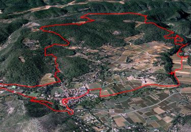
Trail Walking of 12.9 km to be discovered at Provence-Alpes-Côte d'Azur, Var, Correns. This trail is proposed by jo-ba.
Description
boucle
Positioning
Country:
France
Region :
Provence-Alpes-Côte d'Azur
Department/Province :
Var
Municipality :
Correns
Location:
Unknown
Start:(Dec)
Start:(UTM)
261932 ; 4820183 (32T) N.
Comments
Trails nearby
Le patrimoine - l'Argens - Le village
Walking
Easy
(1)
Correns,
Provence-Alpes-Côte d'Azur,
Var,
France
6h 0min
Yes
Correns - Val Obscur - Rive de l'Argens - Grotte aux Fées - Châteauvert - Val...
Walking
Medium
Correns,
Provence-Alpes-Côte d'Azur,
Var,
France
21 km | 27 km-effort
4h 57min
Yes
Correns-18-03-22
Walking
Medium
Correns,
Provence-Alpes-Côte d'Azur,
Var,
France
11.9 km | 14.9 km-effort
4h 10min
Yes
Correns à faire
Mountain bike
Medium
Correns,
Provence-Alpes-Côte d'Azur,
Var,
France
25 km | 32 km-effort
2h 55min
Yes
Correns fait
Mountain bike
Medium
Correns,
Provence-Alpes-Côte d'Azur,
Var,
France
26 km | 34 km-effort
2h 55min
Yes
Correns - Le val Sourn
Walking
Medium
(1)
Correns,
Provence-Alpes-Côte d'Azur,
Var,
France
11.2 km | 15.2 km-effort
3h 16min
Yes
Correns reco Bernard 20.03.17
Walking
Medium
Correns,
Provence-Alpes-Côte d'Azur,
Var,
France
16.5 km | 21 km-effort
4h 34min
Yes
N2 Corens
Walking
Difficult
Correns,
Provence-Alpes-Côte d'Azur,
Var,
France
12 km | 15.4 km-effort
5h 1min
Yes
2023-02-26_07h23m12_marathon_var_provence_verte_23-15580119-1674205419-434
Running
Difficult
Châteauvert,
Provence-Alpes-Côte d'Azur,
Var,
France
42 km | 49 km-effort
4h 30min
No
Circuit inaccessible. Le chemin "Chanche" est désormais fermé par une barrière accompagnée du'un panneau rond blanc cerné de rouge et un additionnel indiquant "voie privée non accessible au public"