Insul SityTrail > Trails > Outdoor > Germany > Rhineland-Palatinate > Landkreis Ahrweiler > Insul SityTrail > Trails > Outdoor > Germany > Rhineland-Palatinate > Landkreis Ahrweiler > Insul Insul suntajl User 3D © OpenStreetMap contributors Length 12.6 km Max alt 535 m Uphill gradient 332 m Km-Effort 17.1 km Min alt 219 m Downhill gradient 332 m Boucle Yes Creation date : 2024-09-29 07:50:44.534 Updated on : 2024-11-23 09:46:20.46 (0 Reviews) Walking 3h52 Difficulty : Medium FREE GPS app for hiking SityTrail IGN / Geographical institutes SityTrail World The world is yours! About 
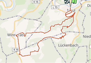
Trail Walking of 12.6 km to be discovered at Rhineland-Palatinate, Landkreis Ahrweiler, Insul. This trail is proposed by suntajl. Legends | More details (PDF) Elevation profile Legends > 15% 15% - 10% 10% - 5% flat 5% - 10% 10% - 15% 15% - 30% > 30% Positioning Country: Germany Region : Rhineland-Palatinate Department/Province : Landkreis Ahrweiler Municipality : Insul Location: Unknown Start:(Dec) 50.4416343 / 6.9152614 Start:(UTM) 351972 ; 5589812 (32U) N. Comments Please log in to post a review or rate the element Trails nearby GUIDE+ Schuld Rundweg 6 On foot Easy Schuld, Rhineland-Palatinate, Landkreis Ahrweiler, Germany 3.3 km | 5.3 km-effort 1h 12min No GUIDE+ EifelSchleife Rund um Rupperath On foot Easy Bad Münstereifel, North Rhine-Westphalia, Kreis Euskirchen, Germany 7.1 km | 9.5 km-effort 2h 9min Yes GUIDE+ [④] Rundweg Ahrbrück 4 On foot Easy Ahrbrück, Rhineland-Palatinate, Landkreis Ahrweiler, Germany 6.2 km | 9.8 km-effort 2h 13min No flip96 Ahrsteig etappe 3 Rondwandeling 37,5km. Walking Difficult Insul, Rhineland-Palatinate, Landkreis Ahrweiler, Germany 33 km | 49 km-effort 11h 5min Yes pvds altenahr4 Walking Medium Hönningen, Rhineland-Palatinate, Landkreis Ahrweiler, Germany 9.9 km | 15.4 km-effort 3h 6min No