sarajevo SityTrail > Trails > Outdoor > Bosnia and Herzegovina > Republika Srpska > City of Istočno Sarajevo > MZ Trebević SityTrail > Trails > Outdoor > Bosnia and Herzegovina > Republika Srpska > City of Istočno Sarajevo > MZ Trebević sarajevo suzanne.bron User 3D © OpenStreetMap contributors Length 2.4 km Max alt 808 m Uphill gradient 1 m Km-Effort 3.2 km Min alt 549 m Downhill gradient 254 m Boucle No Creation date : 2024-10-06 13:18:02.665 Updated on : 2024-10-06 13:57:23.867 (0 Reviews) Walking 39m Difficulty : Easy FREE GPS app for hiking SityTrail IGN / Geographical institutes SityTrail World The world is yours! About 
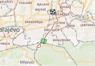
Trail Walking of 2.4 km to be discovered at Republika Srpska, City of Istočno Sarajevo, MZ Trebević. This trail is proposed by suzanne.bron. Legends | More details (PDF) Elevation profile Legends > 15% 15% - 10% 10% - 5% flat 5% - 10% 10% - 15% 15% - 30% > 30% Positioning Country: Bosnia and Herzegovina Region : Republika Srpska Department/Province : City of Istočno Sarajevo Municipality : MZ Trebević Location: Studenkovići Start:(Dec) 43.8436732 / 18.4177427 Start:(UTM) 292424 ; 4857751 (34T) N. Comments Please log in to post a review or rate the element Trails nearby suzanne.bron Sarajevo Walking Easy MZ "Ferhadija", Federation of Bosnia and Herzegovina, City of Sarajevo, Bosnia and Herzegovina 2.5 km | 5.1 km-effort 53min No