![](/images/other/stat-length.png)
![Trail Walking Lachaussée - Etangs de Lachaussée - Photo](https://media.geolcdn.com/t/1900/400/ext.pjpeg?maxdim=2&url=https%3A%2F%2Fstatic1.geolcdn.com%2Fsiteimages%2Fupload%2Ffiles%2F1553511878bg_sport_marche.png)
Etangs de Lachaussée
joelclaudel
User
![Length](/images/other/stat-length.png)
Length
15.1 km
![Max alt](https://static1.geolcdn.com/siteimages/upload/files/1508320355ic_sort_altitude_max_24dp.png)
Max alt
238 m
![Uphill gradient](https://static1.geolcdn.com/siteimages/upload/files/1508320355ic_sort_den_pos_24dp.png)
Uphill gradient
137 m
![Km-Effort](/images/other/stat-length.png)
Km-Effort
16.9 km
![Min alt](https://static1.geolcdn.com/siteimages/upload/files/1508320355ic_sort_altitude_min_24dp.png)
Min alt
209 m
![Downhill gradient](https://static1.geolcdn.com/siteimages/upload/files/1508320355ic_sort_den_neg_24dp.png)
Downhill gradient
138 m
![Boucle](https://static1.geolcdn.com/siteimages/upload/files/16400158638029165_repeat_loop_refresh_sync_direction_icon.png)
Boucle
Yes
Creation date :
2015-05-16 00:00:00.0
Updated on :
2015-05-16 00:00:00.0
![Walking](https://static1.geolcdn.com/sitytour/trail-icons/101.png)
3h44
Difficulty : Medium
![Scan this QR Code to open this trail in the SityTrail application](https://capi.geolives.com/qq0zvz2zws4bq2lad0pu/sitytour/trails/421726/qr.png?size=200)
FREE GPS app for hiking
About
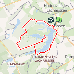
Trail Walking of 15.1 km to be discovered at Grand Est, Meuse, Lachaussée. This trail is proposed by joelclaudel.
Description
Circuit autour de l'étang de Lachaussée (départ église), étang de Minuit, étang Picard.
Eviter l'étang des Grandes Parois, inaccessible, une grille interdit l'entrée.
Positioning
Country:
France
Region :
Grand Est
Department/Province :
Meuse
Municipality :
Lachaussée
Location:
Unknown
Start:(Dec)
Start:(UTM)
705981 ; 5435336 (31U) N.
Comments
Trails nearby
![Trail Cycle Lachaussée - Autour de l'étang de Lachaussée... entre eau et air, Circuit n° 4 - Photo](https://media.geolcdn.com/t/375/260/ext.jpg?maxdim=2&url=https%3A%2F%2Fservices.sitytrail.com%2FGeolivesWS%2FDownloadMedia.ashx%3FTrailID%3D111707%26Media%3D8015_6.jpg)
![Cycle Cycle](https://static1.geolcdn.com/sitytour/trail-icons/200.png)
Autour de l'étang de Lachaussée... entre eau et air, Circuit n° 4
Cycle
Medium
Lachaussée,
Grand Est,
Meuse,
France
![](/images/other/stat-length.png)
26 km | 29 km-effort
1h 30min
![](https://static1.geolcdn.com/siteimages/upload/files/16400158638029165_repeat_loop_refresh_sync_direction_icon.png)
Yes
![Trail Walking Lachaussée - Lachaussée - étangs et prairies - Photo](https://media.geolcdn.com/t/375/260/d2d60ad1-6b56-4f9f-9048-4ea31a763e3d.jpg&format=jpg&maxdim=2)
![Walking Walking](https://static1.geolcdn.com/sitytour/trail-icons/101.png)
Lachaussée - étangs et prairies
Walking
Medium
Lachaussée,
Grand Est,
Meuse,
France
![](/images/other/stat-length.png)
6.7 km | 7.3 km-effort
6h 1min
![](https://static1.geolcdn.com/siteimages/upload/files/16400158638029165_repeat_loop_refresh_sync_direction_icon.png)
Yes
![Trail Walking Lachaussée - Étang Lachaussée - Photo](https://media.geolcdn.com/t/375/260/ext.jpg?maxdim=2&url=https%3A%2F%2Fstatic1.geolcdn.com%2Fsiteimages%2Fupload%2Ffiles%2F1553511878bg_sport_marche.png)
![Walking Walking](https://static1.geolcdn.com/sitytour/trail-icons/101.png)
Étang Lachaussée
Walking
Medium
Lachaussée,
Grand Est,
Meuse,
France
![](/images/other/stat-length.png)
11.3 km | 12.6 km-effort
2h 31min
![](https://static1.geolcdn.com/siteimages/upload/files/16400158638029165_repeat_loop_refresh_sync_direction_icon.png)
Yes
![Trail Horseback riding Hagéville - Hageville - Photo](https://media.geolcdn.com/t/375/260/ext.jpg?maxdim=2&url=https%3A%2F%2Fstatic1.geolcdn.com%2Fsiteimages%2Fupload%2Ffiles%2F1524743154cheval.jpg)
![Horseback riding Horseback riding](https://static1.geolcdn.com/sitytour/trail-icons/301.png)
Hageville
Horseback riding
Medium
Hagéville,
Grand Est,
Meurthe-et-Moselle,
France
![](/images/other/stat-length.png)
21 km | 23 km-effort
4h 57min
![](https://static1.geolcdn.com/siteimages/upload/files/16400158638029165_repeat_loop_refresh_sync_direction_icon.png)
No
![Trail Walking Lachaussée - lachaussee - Photo](https://media.geolcdn.com/t/375/260/ext.jpg?maxdim=2&url=https%3A%2F%2Fstatic1.geolcdn.com%2Fsiteimages%2Fupload%2Ffiles%2F1553511878bg_sport_marche.png)
![Walking Walking](https://static1.geolcdn.com/sitytour/trail-icons/101.png)
![Trail Walking Lachaussée - Lachaussée - Photo](https://media.geolcdn.com/t/375/260/ext.jpg?maxdim=2&url=https%3A%2F%2Fstatic1.geolcdn.com%2Fsiteimages%2Fupload%2Ffiles%2F1553511878bg_sport_marche.png)
![Walking Walking](https://static1.geolcdn.com/sitytour/trail-icons/101.png)
![Trail Mountain bike Lachaussée - lachaussee_hattonchatel_AR - Photo](https://media.geolcdn.com/t/375/260/ext.jpg?maxdim=2&url=https%3A%2F%2Fstatic1.geolcdn.com%2Fsiteimages%2Fupload%2Ffiles%2F1524743154velo.jpg)
![Mountain bike Mountain bike](https://static1.geolcdn.com/sitytour/trail-icons/202.png)
lachaussee_hattonchatel_AR
Mountain bike
Easy
Lachaussée,
Grand Est,
Meuse,
France
![](/images/other/stat-length.png)
41 km | 47 km-effort
4h 29min
![](https://static1.geolcdn.com/siteimages/upload/files/16400158638029165_repeat_loop_refresh_sync_direction_icon.png)
Yes
![Trail Cycle Lachaussée - Lorraine Tour Parc Ouest étape 6 - Photo](https://media.geolcdn.com/t/375/260/ext.jpg?maxdim=2&url=https%3A%2F%2Fstatic1.geolcdn.com%2Fsiteimages%2Fupload%2Ffiles%2F1524743154velo.jpg)
![Cycle Cycle](https://static1.geolcdn.com/sitytour/trail-icons/200.png)
Lorraine Tour Parc Ouest étape 6
Cycle
Very easy
Lachaussée,
Grand Est,
Meuse,
France
![](/images/other/stat-length.png)
52 km | 59 km-effort
5h 30min
![](https://static1.geolcdn.com/siteimages/upload/files/16400158638029165_repeat_loop_refresh_sync_direction_icon.png)
No
belle rando mais ne pas hésiter à empreinter des sentiers parallèles pour être plus au coeur de la forêt avec un passage près d un chêne magnifique