![](/images/other/stat-length.png)
![Trail Horseback riding Erpe-Mere - Erpe Mere - Photo](https://media.geolcdn.com/t/1900/400/ext.pjpeg?maxdim=2&url=https%3A%2F%2Fstatic1.geolcdn.com%2Fsiteimages%2Fupload%2Ffiles%2F1524743154cheval.jpg)
Erpe Mere
eddyvermeulen1
User
![Length](/images/other/stat-length.png)
Length
13.1 km
![Max alt](https://static1.geolcdn.com/siteimages/upload/files/1508320355ic_sort_altitude_max_24dp.png)
Max alt
65 m
![Uphill gradient](https://static1.geolcdn.com/siteimages/upload/files/1508320355ic_sort_den_pos_24dp.png)
Uphill gradient
112 m
![Km-Effort](/images/other/stat-length.png)
Km-Effort
14.6 km
![Min alt](https://static1.geolcdn.com/siteimages/upload/files/1508320355ic_sort_altitude_min_24dp.png)
Min alt
20 m
![Downhill gradient](https://static1.geolcdn.com/siteimages/upload/files/1508320355ic_sort_den_neg_24dp.png)
Downhill gradient
111 m
![Boucle](https://static1.geolcdn.com/siteimages/upload/files/16400158638029165_repeat_loop_refresh_sync_direction_icon.png)
Boucle
Yes
Creation date :
2024-09-28 07:26:21.17
Updated on :
2024-09-28 16:22:17.412
![Horseback riding](https://static1.geolcdn.com/sitytour/trail-icons/301.png)
1h55
Difficulty : Easy
![Scan this QR Code to open this trail in the SityTrail application](https://capi.geolives.com/qq0zvz2zws4bq2lad0pu/sitytour/trails/4206056/qr.png?size=200)
FREE GPS app for hiking
About
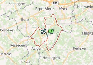
Trail Horseback riding of 13.1 km to be discovered at Flanders, East Flanders, Erpe-Mere. This trail is proposed by eddyvermeulen1.
Description
ingekort en getest op 28/9/24 op basis van gevonden tocht op internet.
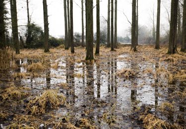
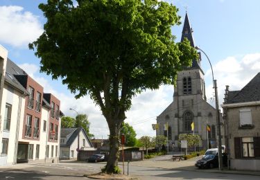
gedaan op 28/9/2024. Mooie streek, mooie slagen, mooi door het natuurgebied. Wel enkele drukke straten erbij nemen, en enkele drukke dorpskommen. Niet altijd ongevaarlijk.
Positioning
Country:
Belgium
Region :
Flanders
Department/Province :
East Flanders
Municipality :
Erpe-Mere
Location:
Aaigem
Start:(Dec)
Start:(UTM)
566788 ; 5639012 (31U) N.
Comments
Trails nearby
![Trail On foot Erpe-Mere - Den Dotter rood - Photo](https://media.geolcdn.com/t/375/260/7a0e4265-fac6-403a-9dde-dd3fd7d12ea9.jpeg&format=jpg&maxdim=2)
![On foot On foot](https://static1.geolcdn.com/sitytour/trail-icons/100.png)
Den Dotter rood
On foot
Easy
Erpe-Mere,
Flanders,
East Flanders,
Belgium
![](/images/other/stat-length.png)
7.8 km | 8.9 km-effort
2h 1min
![](https://static1.geolcdn.com/siteimages/upload/files/16400158638029165_repeat_loop_refresh_sync_direction_icon.png)
Yes
![Trail On foot Sint-Lievens-Houtem - Natuurwandeling Vlierzele - Photo](https://media.geolcdn.com/t/375/260/00722387-8ee2-4be1-a07c-6c0eb6d62503.jpeg&format=jpg&maxdim=2)
![On foot On foot](https://static1.geolcdn.com/sitytour/trail-icons/100.png)
Natuurwandeling Vlierzele
On foot
Easy
Sint-Lievens-Houtem,
Flanders,
East Flanders,
Belgium
![](/images/other/stat-length.png)
10.1 km | 11.3 km-effort
2h 34min
![](https://static1.geolcdn.com/siteimages/upload/files/16400158638029165_repeat_loop_refresh_sync_direction_icon.png)
Yes
![Trail Walking Haaltert - Lebbeke-Outer Kouterwandeling Nederhasselt - 9 km RT - Photo](https://media.geolcdn.com/t/375/260/ext.jpg?maxdim=2&url=https%3A%2F%2Fstatic1.geolcdn.com%2Fsiteimages%2Fupload%2Ffiles%2F1553511878bg_sport_marche.png)
![Walking Walking](https://static1.geolcdn.com/sitytour/trail-icons/101.png)
Lebbeke-Outer Kouterwandeling Nederhasselt - 9 km RT
Walking
Very easy
(1)
Haaltert,
Flanders,
East Flanders,
Belgium
![](/images/other/stat-length.png)
9.3 km | 10.2 km-effort
Unknown
![](https://static1.geolcdn.com/siteimages/upload/files/16400158638029165_repeat_loop_refresh_sync_direction_icon.png)
Yes
![Trail Horseback riding Erpe-Mere - Ruiterroute Burst-Ressegem-Woubrechtegem 12 km - Photo](https://media.geolcdn.com/t/375/260/ext.jpg?maxdim=2&url=https%3A%2F%2Fstatic1.geolcdn.com%2Fsiteimages%2Fupload%2Ffiles%2F1524743154cheval.jpg)
![Horseback riding Horseback riding](https://static1.geolcdn.com/sitytour/trail-icons/301.png)
Ruiterroute Burst-Ressegem-Woubrechtegem 12 km
Horseback riding
Easy
(1)
Erpe-Mere,
Flanders,
East Flanders,
Belgium
![](/images/other/stat-length.png)
10.8 km | 12 km-effort
1h 34min
![](https://static1.geolcdn.com/siteimages/upload/files/16400158638029165_repeat_loop_refresh_sync_direction_icon.png)
Yes
![Trail On foot Erpe-Mere - Den Dotter - Photo](https://media.geolcdn.com/t/375/260/9dcf633f-44ef-4719-92df-3cd1acfb1a7b.jpeg&format=jpg&maxdim=2)
![On foot On foot](https://static1.geolcdn.com/sitytour/trail-icons/100.png)
Den Dotter
On foot
Easy
Erpe-Mere,
Flanders,
East Flanders,
Belgium
![](/images/other/stat-length.png)
9.2 km | 10.7 km-effort
2h 25min
![](https://static1.geolcdn.com/siteimages/upload/files/16400158638029165_repeat_loop_refresh_sync_direction_icon.png)
Yes
![Trail On foot Ninove - Galgeveldwandeling - Photo](https://media.geolcdn.com/t/375/260/6d1570e7-c08a-447f-a7dd-0ca4dd417e07.jpeg&format=jpg&maxdim=2)
![On foot On foot](https://static1.geolcdn.com/sitytour/trail-icons/100.png)
Galgeveldwandeling
On foot
Easy
Ninove,
Flanders,
East Flanders,
Belgium
![](/images/other/stat-length.png)
8.9 km | 9.8 km-effort
2h 13min
![](https://static1.geolcdn.com/siteimages/upload/files/16400158638029165_repeat_loop_refresh_sync_direction_icon.png)
Yes
![Trail Walking Haaltert - mussenzele - Photo](https://media.geolcdn.com/t/375/260/ext.jpg?maxdim=2&url=https%3A%2F%2Fstatic1.geolcdn.com%2Fsiteimages%2Fupload%2Ffiles%2F1553511878bg_sport_marche.png)
![Walking Walking](https://static1.geolcdn.com/sitytour/trail-icons/101.png)
mussenzele
Walking
Easy
(1)
Haaltert,
Flanders,
East Flanders,
Belgium
![](/images/other/stat-length.png)
4.9 km | 5.4 km-effort
Unknown
![](https://static1.geolcdn.com/siteimages/upload/files/16400158638029165_repeat_loop_refresh_sync_direction_icon.png)
Yes
![Trail Walking Herzele - Herzele - Photo](https://media.geolcdn.com/t/375/260/6ae3ac60-9229-43bb-9d4c-5a98bebc966f.jpg&format=jpg&maxdim=2)
![Walking Walking](https://static1.geolcdn.com/sitytour/trail-icons/101.png)
![Trail On foot Sint-Lievens-Houtem - Natuurwandeling Letterhoutem - Photo](https://media.geolcdn.com/t/375/260/ext.jpg?maxdim=2&url=https%3A%2F%2Fstatic1.geolcdn.com%2Fsiteimages%2Fupload%2Ffiles%2F1545311037marcheuse_200dpi.jpg)
![On foot On foot](https://static1.geolcdn.com/sitytour/trail-icons/100.png)
Natuurwandeling Letterhoutem
On foot
Easy
Sint-Lievens-Houtem,
Flanders,
East Flanders,
Belgium
![](/images/other/stat-length.png)
11.1 km | 12.6 km-effort
2h 51min
![](https://static1.geolcdn.com/siteimages/upload/files/16400158638029165_repeat_loop_refresh_sync_direction_icon.png)
Yes
25/1/04 gedaan bij koud weer 0*C In het begin veel stap maar deel 2 maakt het goed