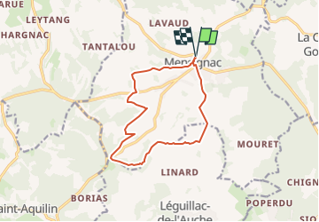
Trail Walking Mensignac - randogps24-658 - Photo
 swp648
swp648

User

© OpenStreetMap contributors
Length
Length
12.4 km
Max alt
Max alt
227 m
Uphill gradient
Uphill gradient
249 m
Km-Effort
Km-Effort  
15.7 km
Min alt
Min alt
121 m
Downhill gradient
Downhill gradient
250 m
Boucle
Boucle
Yes
Creation date :
2024-09-26 09:57:13.34
Updated on :
2024-09-26 09:59:41.627

(0 Reviews)

Walking
Walking
3h33
Difficulty : Difficult

Scan this QR Code to open this trail in the SityTrail application

FREE GPS app for hiking

Logo SityTrail SityTrail

IGN / Geographical institutes

Download SityTrail from the App Store Download SityTrail from Google Play

Logo SityTrail SityTrail World

The world is yours!

Download SityTrail from the App Store Download SityTrail from Google Play Download SityTrail on Huawei AppGallery

About

Trail Walking of 12.4 km to be discovered at New Aquitaine, Dordogne, Mensignac. This trail is proposed by swp648.

Description

Départ parking de la mairie du bourg de Mensignac

Elevation profile

Positioning

Country:
France
Region :
New Aquitaine
Department/Province :
Dordogne
Municipality :
Mensignac
Location:
Unknown
Start:(UTM)
308504 ; 5011119 (31T) N.

Trails nearby

Trail Walking Léguillac-de-l'Auche - Leguillac 12km - Photo
Walking
amelie14

Walking

Medium
Léguillac-de-l'Auche, New Aquitaine, Dordogne, France
12.1 km | 16.1 km-effort
2h 45min
Yes
Trail Walking Léguillac-de-l'Auche - 24 Léguillac de l'Auche - Photo
Walking
Patxito

Walking

Easy
Léguillac-de-l'Auche, New Aquitaine, Dordogne, France
13.8 km | 18 km-effort
3h 57min
Yes
Trail Walking Annesse-et-Beaulieu - Boucle gare de Beaulieu - Photo
Walking
CC.RIDER

Walking

Difficult
Annesse-et-Beaulieu, New Aquitaine, Dordogne, France
13.9 km | 17.5 km-effort
3h 58min
Yes
Trail Walking Mensignac - Boucle de Mensignac - Photo
Walking
CC.RIDER

Walking

Difficult
Mensignac, New Aquitaine, Dordogne, France
13.6 km | 16.6 km-effort
3h 46min
Yes
Trail Nordic walking La Chapelle-Gonaguet - SityTrail - La Chapelle-Gonaguet - Photo
Nordic walking
Melifera

Nordic walking

Easy
La Chapelle-Gonaguet, New Aquitaine, Dordogne, France
15.1 km | 18.5 km-effort
2h 40min
Yes
Trail Walking Léguillac-de-l'Auche - Sentier de Lafaye-n°9 - Photo
Walking
sidore

Walking

Easy
Léguillac-de-l'Auche, New Aquitaine, Dordogne, France
6.9 km | 8.7 km-effort
1h 27min
Yes
Trail Walking La Chapelle-Gonaguet - La Chapelle-Gonaguet - Photo
Walking
CC.RIDER

Walking

Easy
La Chapelle-Gonaguet, New Aquitaine, Dordogne, France
15.1 km | 18.5 km-effort
3h 58min
Yes
Trail Walking Bussac - Bussac 2 revu AJC 10km - Photo
Walking
YV24

Walking

Easy
Bussac, New Aquitaine, Dordogne, France
9.6 km | 12.2 km-effort
2h 40min
Yes
Trail Walking La Chapelle-Gonaguet - La Chapelle-Gonaguet Brunies 10km - Photo
Walking
YV24

Walking

Easy
La Chapelle-Gonaguet, New Aquitaine, Dordogne, France
9.8 km | 12.2 km-effort
2h 42min
Yes


Close
My subscriptions