![](/images/other/stat-length.png)
![Trail Walking Saint Vith - RF-Lg-15_Recht - Photo](https://media.geolcdn.com/t/1900/400/ext.pjpeg?maxdim=2&url=https%3A%2F%2Fstatic1.geolcdn.com%2Fsiteimages%2Fupload%2Ffiles%2F1553511878bg_sport_marche.png)
RF-Lg-15_Recht
GR Rando
Randonnez sur et autour des GR ® wallons (Sentiers de Grande Randonnée). PRO
![Length](/images/other/stat-length.png)
![Max alt](https://static1.geolcdn.com/siteimages/upload/files/1508320355ic_sort_altitude_max_24dp.png)
![Uphill gradient](https://static1.geolcdn.com/siteimages/upload/files/1508320355ic_sort_den_pos_24dp.png)
![Km-Effort](/images/other/stat-length.png)
![Min alt](https://static1.geolcdn.com/siteimages/upload/files/1508320355ic_sort_altitude_min_24dp.png)
![Downhill gradient](https://static1.geolcdn.com/siteimages/upload/files/1508320355ic_sort_den_neg_24dp.png)
![Boucle](https://static1.geolcdn.com/siteimages/upload/files/16400158638029165_repeat_loop_refresh_sync_direction_icon.png)
![Walking](https://static1.geolcdn.com/sitytour/trail-icons/101.png)
2h59
Difficulty : Unknown
![Scan this QR Code to open this trail in the SityTrail application](https://capi.geolives.com/qq0zvz2zws4bq2lad0pu/sitytour/trails/420211/qr.png?size=200)
FREE GPS app for hiking
About
Trail Walking of 9.9 km to be discovered at Wallonia, Liège, Saint Vith. This trail is proposed by GR Rando.
Description
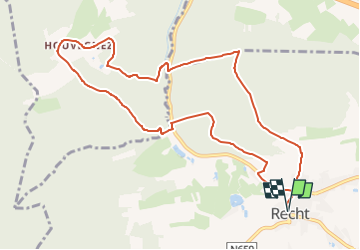
RF-LG-15 - Raccourci - En zigzaguant dans la vallée du Rechterbach
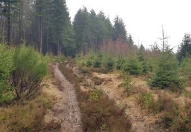
Dans quel type de paysage randonnons-nous?
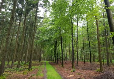
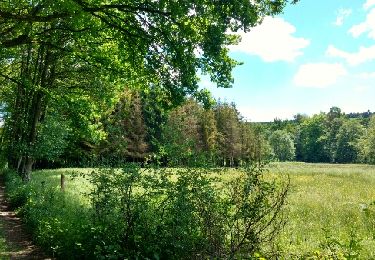
En traversant deux fois le Rechterbach (ruisseau de Recht) et en gravissant les deux versants de la vallée, nous aurons tout loisir d’admirer les paysages de pâtures et de bois, très vallonnés, voire escarpés, qui dominent le village de Recht.
Difficulté ?
Cette balade peut être considérée comme relativement ardue. Les pentes raides se succèdent.
Combien de kilomètres ?
9,9 km.
Sur quel GR randonnons-nous ?
La partie initiale de la balade emprunte le GR 56 «Cantons de l’Est et parc naturel “Hautes-Fagnes – Nord-Eifel”».
Où démarrons-nous ?
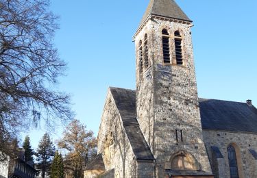
À l’église de Recht (carte Michelin n° 534, pli V/20) (grand parking).
Comment y arriver ?
Par la N660 (Ligneuville – Recht) ou la N659 (Amel (Amblève) – Recht).
Que découvrons-nous aujourd’hui ?
À Recht, nous pourrons visiter une galerie souterraine où, il n’y a pas si longtemps, on extrayait encore une sorte de schiste qui n’était pas destiné à la fabrication d’ardoises ou de lauzes : la pierre bleue.
À quelques kilomètres de Recht, le musée Poteau ’44 nous fera revivre un épisode tragique de la bataille des Ardennes.
Quelle est la carte IGN de référence ?
Carte IGN au 1:20 000 : «Vielsalm – Recht», 56/1-2.
Transports en commun ?
Aucun à une heure utile.
Positioning
Comments
Trails nearby
![Trail Walking Saint Vith - 2021-05-17_18h38m48_recht - Photo](https://media.geolcdn.com/t/375/260/df57db6f-82de-45d3-a1f9-f0242505f9de.jpg&format=jpg&maxdim=2)
![Walking Walking](https://static1.geolcdn.com/sitytour/trail-icons/101.png)
Walking
![](/images/other/stat-length.png)
![](https://static1.geolcdn.com/siteimages/upload/files/16400158638029165_repeat_loop_refresh_sync_direction_icon.png)
![Trail Walking Malmedy - ligneuville - ondeval aller retour - Photo](https://media.geolcdn.com/t/375/260/5d217ee2-30bd-4bc8-82e6-a4da860aa974.jpg&format=jpg&maxdim=2)
![Walking Walking](https://static1.geolcdn.com/sitytour/trail-icons/101.png)
Walking
![](/images/other/stat-length.png)
![](https://static1.geolcdn.com/siteimages/upload/files/16400158638029165_repeat_loop_refresh_sync_direction_icon.png)
![Trail Roller skating Malmedy - Vallée de l'Amblève - Photo](https://media.geolcdn.com/t/375/260/ext.jpg?maxdim=2&url=https%3A%2F%2Fservices.sitytrail.com%2FGeolivesWS%2FDownloadMedia.ashx%3FTrailID%3D767158%26Media%3Dfix__20170605123453.jpg)
![Roller skating Roller skating](https://static1.geolcdn.com/sitytour/trail-icons/901.png)
Roller skating
![](/images/other/stat-length.png)
![](https://static1.geolcdn.com/siteimages/upload/files/16400158638029165_repeat_loop_refresh_sync_direction_icon.png)
![Trail Walking Saint Vith - Rodt - Chiens de traineau - Photo](https://media.geolcdn.com/t/375/260/1e66ffeb-aa18-4dc8-9647-91e8788c7358.jpg&format=jpg&maxdim=2)
![Walking Walking](https://static1.geolcdn.com/sitytour/trail-icons/101.png)
Walking
![](/images/other/stat-length.png)
![](https://static1.geolcdn.com/siteimages/upload/files/16400158638029165_repeat_loop_refresh_sync_direction_icon.png)
![Walking Walking](https://static1.geolcdn.com/sitytour/trail-icons/101.png)
Walking
![](/images/other/stat-length.png)
![](https://static1.geolcdn.com/siteimages/upload/files/16400158638029165_repeat_loop_refresh_sync_direction_icon.png)
![Trail On foot Stavelot - 4. Promenade de l'Ecureuil - Photo](https://media.geolcdn.com/t/375/260/a994dd92-9fdf-4425-832e-ec7cd6a4ee8b.jpeg&format=jpg&maxdim=2)
![On foot On foot](https://static1.geolcdn.com/sitytour/trail-icons/100.png)
On foot
![](/images/other/stat-length.png)
![](https://static1.geolcdn.com/siteimages/upload/files/16400158638029165_repeat_loop_refresh_sync_direction_icon.png)
![Trail On foot Trois-Ponts - Liaison - Photo](https://media.geolcdn.com/t/375/260/e76f3a7b-19a9-4fd4-95e5-f56c159ed203.jpeg&format=jpg&maxdim=2)
![On foot On foot](https://static1.geolcdn.com/sitytour/trail-icons/100.png)
![Trail Walking Saint Vith - Recht 22 km - Photo](https://media.geolcdn.com/t/375/260/a9f794ab-d5e8-4cf0-8525-510ce3401da7.jpeg&format=jpg&maxdim=2)
![Walking Walking](https://static1.geolcdn.com/sitytour/trail-icons/101.png)
![Trail Walking Stavelot - Refat 17,3km - Photo](https://media.geolcdn.com/t/375/260/ext.jpg?maxdim=2&url=https%3A%2F%2Fstatic1.geolcdn.com%2Fsiteimages%2Fupload%2Ffiles%2F1553511878bg_sport_marche.png)
![Walking Walking](https://static1.geolcdn.com/sitytour/trail-icons/101.png)
Walking
![](/images/other/stat-length.png)
![](https://static1.geolcdn.com/siteimages/upload/files/16400158638029165_repeat_loop_refresh_sync_direction_icon.png)