


22 km | 29 km-effort


Randonnez sur et autour des GR ® wallons (Sentiers de Grande Randonnée). PRO


FREE GPS app for hiking
 SityTrail
IGN / Geographical institutes
SityTrail World
The world is yours!
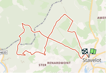
Trail Walking of 11 km to be discovered at Wallonia, Liège, Stavelot. This trail is proposed by GR Rando.
RF-Lg-14 Sur les crêtes de l’Amblève : Stavelot.
Dans quel type de paysage randonnons-nous ?
Cette randonnée assez aérienne va nous conduire à travers de belles forêts qui s’ouvrent à tout bout de champ sur de magnifiques panoramas.
Difficultés ?
Le départ de la balade est assez raide. Deux autres côtes pas bien méchantes.
Sur quel GR randonnons-nous ?
Après avoir zigzagué à travers le versant nord de la vallée de l’Amblève, nous rejoignons Stavelot en compagnie des balises du GR 5 «Mer du Nord – Méditerranée».
Où démarrons-nous ?
Place Saint-Remacle, la jolie place au perron du centre de Stavelot (carte Michelin n° 534, pli U/20).
Comment y arriver ?
Autoroute E42, puis N68 jusqu’à Stavelot. Ou bien rejoindre Stavelot au départ de Trois-Ponts. En venant de l’E42 ou de Francorchamps, prendre la direction «Centre» au rond-point à l’entrée de Stavelot, puis par la rue Ferdinand Nicolay et, à droite, par la rue Général Jacques, arriver à la place Saint-Remacle.
En arrivant de Trois-Ponts, prendre la direction «Centre» au rond-point à l’entrée du bourg, puis, par la rue Neuve et la rue Henri Massange, ensuite par la rue Général Jacques à gauche, atteindre la place Saint-Remacle.
Que découvrons-nous aujourd’hui ?
Le musée du Circuit de Francorchamps à l’abbaye de Stavelot en séduira plus d’un.
Quelle est la carte IGN de référence ?
Carte IGN au 1:20 000: «Malmedy – Stavelot», 50/5-6.
Transports en commun ?
Arrêt «Stavelot - Écoles», à 250 mètres du point de départ : Bus TEC n° 294 Verviers – Stavelot – Trois-Ponts (tous les jours) ; Bus TEC n° 745 Trois-Ponts – Waimes – Büllingen (tous les jours, services nombreux).


Walking

Walking

Walking

Walking

Walking

Trail

Trail

Trail
Super !
Superbe parcours. 💚 Balade coup de coeur !