


20240924
© OpenStreetMap contributors


1h16
Difficulty : Easy


Length
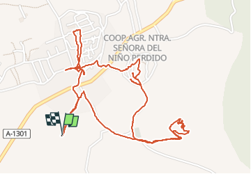
3.8 km
Max alt
807 m
Uphill gradient
78 m
Km-Effort
4.9 km
Min alt
758 m
Downhill gradient
77 m
Boucle
Yes
Creation date :
2024-09-24 11:25:54.659
Updated on :
2024-09-24 13:55:45.095
1h16
Difficulty : Easy
FREE GPS app for hiking
 SityTrail
IGN / Geographical institutes
SityTrail World
The world is yours!
About
Trail Walking of 3.8 km to be discovered at Aragon, Zaragoza, Tabuenca. This trail is proposed by Philippe Brandenbourger.
Positioning
Country:
Spain
Region :
Aragon
Department/Province :
Zaragoza
Municipality :
Tabuenca
Location:
Unknown
Start:(Dec)
Start:(UTM)
621142 ; 4616595 (30T) N.
Comments
Trails nearby