Trail Mountain bike Riervescemont - Riervescemont Baerenkopf - Photo
 qlqin
qlqin

User

© OpenStreetMap contributors
Length
Length
16.3 km
Max alt
Max alt
1070 m
Uphill gradient
Uphill gradient
627 m
Km-Effort
Km-Effort  
25 km
Min alt
Min alt
548 m
Downhill gradient
Downhill gradient
633 m
Boucle
Boucle
Yes
Creation date :
2024-09-22 13:36:52.473
Updated on :
2024-09-22 21:11:22.195

(0 Reviews)

Mountain bike
Mountain bike
2h00
Difficulty : Difficult
Electric bike
Electric bike
1h32
Difficulty : Medium

Scan this QR Code to open this trail in the SityTrail application

FREE GPS app for hiking

Logo SityTrail SityTrail

IGN / Geographical institutes

Download SityTrail from the App Store Download SityTrail from Google Play

Logo SityTrail SityTrail World

The world is yours!

Download SityTrail from the App Store Download SityTrail from Google Play Download SityTrail on Huawei AppGallery

About

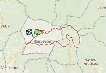
Trail Mountain bike of 16.3 km to be discovered at Bourgogne-Franche-Comté, Territoire-de-Belfort, Riervescemont. This trail is proposed by qlqin.

Description

Chouette rando VTT d'automne

Elevation profile

Positioning

Country:
France
Region :
Bourgogne-Franche-Comté
Department/Province :
Territoire-de-Belfort
Municipality :
Riervescemont
Location:
Unknown
Start:(UTM)
340461 ; 5292597 (32T) N.

Trails nearby

Trail Walking Sewen - Boucle entre les lacs de Sewen et d'Alfeld - Photo
Walking
tracegps

Walking

Medium
(1)
Sewen, Grand Est, Haut-Rhin, France
8.1 km | 12.3 km-effort
2h 30min
Yes
Trail Walking Lepuix - Le Tremontkopf - Photo
Walking
tracegps

Walking

Medium
(1)
Lepuix, Bourgogne-Franche-Comté, Territoire-de-Belfort, France
9.1 km | 17.3 km-effort
3h 0min
Yes
Trail Walking Plancher-les-Mines - 2025-01-04 Rando Polaire Dolleren Ballon Alsace Etape 3 - Photo
Walking
GUIDE
holtzv

Walking

Very difficult
Plancher-les-Mines, Bourgogne-Franche-Comté, Haute-Saône, France
18.6 km | 30 km-effort
6h 52min
No
Trail Walking Dolleren - 2025-01-03 Rando Polaire Dolleren Ballon Alsace Etape 2 - Photo
Walking
GUIDE
holtzv

Walking

Very difficult
Dolleren, Grand Est, Haut-Rhin, France
17.3 km | 26 km-effort
6h 0min
No
Trail Walking Dolleren - suuntoapp-Hiking-2025-01-02T19-20-24Z - Photo
Walking
GUIDE
holtzv

Walking

Medium
Dolleren, Grand Est, Haut-Rhin, France
4.3 km | 8.1 km-effort
1h 50min
No
Trail Walking Kirchberg - 2022-07-15 Marche Refuge Baerenkopf Auberge Gazon Vert - Photo
Walking
GUIDE
holtzv

Walking

Very difficult
Kirchberg, Grand Est, Haut-Rhin, France
23 km | 38 km-effort
8h 21min
No
Trail Walking Lepuix - ballon alsace saut de la truite - Photo
Walking
tidouce

Walking

Very easy
(1)
Lepuix, Bourgogne-Franche-Comté, Territoire-de-Belfort, France
9.2 km | 15.5 km-effort
3h 31min
Yes
Trail Walking Lepuix - Malvaux - Ballon d'Alsace - La Gentiane - Photo
Walking
Bart2015

Walking

Very difficult
Lepuix, Bourgogne-Franche-Comté, Territoire-de-Belfort, France
14.2 km | 24 km-effort
5h 23min
Yes
Trail Walking Lepuix - Malvaux - Ballon d'Alsace (15/12 au 15/7) - Photo
Walking
Bart2015

Walking

Very difficult
Lepuix, Bourgogne-Franche-Comté, Territoire-de-Belfort, France
14.8 km | 24 km-effort
5h 33min
Yes


Close
My subscriptions