Trail  Uchaux - 2024-09-22_19h35m03_rando-marche-nordique-des-dejantes-a-uchaux - Photo

2024-09-22_19h35m03_rando-marche-nordique-des-dejantes-a-uchaux

 losjo
losjo

User

© OpenStreetMap contributors
Length
Length
14.9 km
Max alt
Max alt
273 m
Uphill gradient
Uphill gradient
310 m
Km-Effort
Km-Effort  
19 km
Min alt
Min alt
89 m
Downhill gradient
Downhill gradient
310 m
Boucle
Boucle
Yes
Creation date :
2024-09-22 17:35:03.308
Updated on :
2024-09-22 17:35:03.942

(0 Reviews)


Scan this QR Code to open this trail in the SityTrail application

FREE GPS app for hiking

Logo SityTrail SityTrail

IGN / Geographical institutes

Download SityTrail from the App Store Download SityTrail from Google Play

Logo SityTrail SityTrail World

The world is yours!

Download SityTrail from the App Store Download SityTrail from Google Play Download SityTrail on Huawei AppGallery

About

Trail of 14.9 km to be discovered at Provence-Alpes-Côte d'Azur, Vaucluse, Uchaux. This trail is proposed by losjo.

Description

circuit Marche Nordique effectué lors de la randonnée organisée par le club de VTT de UCHAUX (Vaucluse)

Elevation profile

Positioning

Country:
France
Region :
Provence-Alpes-Côte d'Azur
Department/Province :
Vaucluse
Municipality :
Uchaux
Location:
Unknown
Start:(UTM)
643784 ; 4896684 (31T) N.

Trails nearby

Trail Walking Sérignan-du-Comtat - Les Bois d'Uchaux - Sérignan du Comtat - Photo
Walking
tracegps

Walking

Medium
(1)
Sérignan-du-Comtat, Provence-Alpes-Côte d'Azur, Vaucluse, France
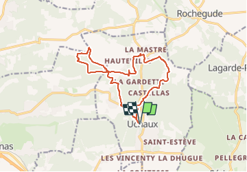
18.8 km | 24 km-effort
4h 0min
Yes
Trail Walking Piolenc - Piolenc - Valbonnette - La Barjavelle - Photo
Walking
tracegps

Walking

Medium
(1)
Piolenc, Provence-Alpes-Côte d'Azur, Vaucluse, France
9.1 km | 11.6 km-effort
2h 40min
Yes
Trail Mountain bike Sérignan-du-Comtat - Sérignan du Comtat - Massif d'Uchaux - Le Castellas - Photo
Mountain bike
tracegps

Mountain bike

Difficult
(1)
Sérignan-du-Comtat, Provence-Alpes-Côte d'Azur, Vaucluse, France
27 km | 34 km-effort
3h 0min
Yes
Trail Walking Piolenc - 84 st montant zel - Photo
Walking
GUIDE
randodyssée

Walking

Easy
Piolenc, Provence-Alpes-Côte d'Azur, Vaucluse, France
14.6 km | 19.4 km-effort
6h 1min
Yes
Trail Walking Piolenc - Piolenc-Les Grottes-Chapelle St Baudile-Ancienne Forteresse de Mornas14km.. - Photo
Walking
chancha

Walking

Difficult
Piolenc, Provence-Alpes-Côte d'Azur, Vaucluse, France
14.2 km | 18.5 km-effort
4h 12min
Yes
Trail Walking Piolenc - Piolenc, Mornas  - Photo
Walking
gout.marc

Walking

Easy
Piolenc, Provence-Alpes-Côte d'Azur, Vaucluse, France
10.8 km | 13.5 km-effort
2h 34min
Yes
Trail Walking Rochegude - rocherude - Photo
Walking
gout.marc

Walking

Very easy
(1)
Rochegude, Auvergne-Rhône-Alpes, Drôme, France
12.3 km | 16.4 km-effort
2h 30min
Yes
Trail Walking Uchaux - le farjons - Photo
Walking
Vero7684

Walking

Easy
Uchaux, Provence-Alpes-Côte d'Azur, Vaucluse, France
15.1 km | 19 km-effort
4h 49min
Yes
Trail Walking Piolenc - Piolenc - Chapelle St Baudile - Ancienne Forteresse de Mornas - Photo
Walking
Loli27

Walking

Medium
(1)
Piolenc, Provence-Alpes-Côte d'Azur, Vaucluse, France
13.7 km | 18 km-effort
3h 49min
Yes


Close
My subscriptions