Trail Walking Niederhaslach - Niederhaslach - châteaux Ringelstein - Rochers du Pfaffenlapp et du Breitberg - Photo

Niederhaslach - châteaux Ringelstein - Rochers du Pfaffenlapp et du Breitberg

 Bart2015
Bart2015

User

© OpenStreetMap contributors
Length
Length
18.2 km
Max alt
Max alt
686 m
Uphill gradient
Uphill gradient
688 m
Km-Effort
Km-Effort  
27 km
Min alt
Min alt
251 m
Downhill gradient
Downhill gradient
688 m
Boucle
Boucle
Yes
Creation date :
2024-09-22 08:03:58.053
Updated on :
2024-09-22 16:31:42.849

(0 Reviews)

Walking
Walking
6h13
Difficulty : Very difficult

Scan this QR Code to open this trail in the SityTrail application

FREE GPS app for hiking

Logo SityTrail SityTrail

IGN / Geographical institutes

Download SityTrail from the App Store Download SityTrail from Google Play

Logo SityTrail SityTrail World

The world is yours!

Download SityTrail from the App Store Download SityTrail from Google Play Download SityTrail on Huawei AppGallery

About

Trail Walking of 18.2 km to be discovered at Grand Est, Bas-Rhin, Niederhaslach. This trail is proposed by Bart2015.

Description

Belle ranado au départ de Niederhaslach, passant par Oberhaslach pour découvrir les ruines des châteaux du Grand et du Petit Ringelstein, puis le Rocher du Pfaffenlapp et sa belle vue, puis le Rocher du Breitberg. La montée vers les châteaux est assez raide ... D'autres découvertes pourront agrémenter la balade ...
Bonne rando, soyez prudent ...

Elevation profile

Photos

Positioning

Country:
France
Region :
Grand Est
Department/Province :
Bas-Rhin
Municipality :
Niederhaslach
Location:
Unknown
Start:(UTM)
377625 ; 5377970 (32U) N.

Trails nearby

Trail Walking Urmatt - Cascade Soultzbach - Urmatt - Photo
Walking
Mich&Agnès

Walking

Very difficult
(1)
Urmatt, Grand Est, Bas-Rhin, France
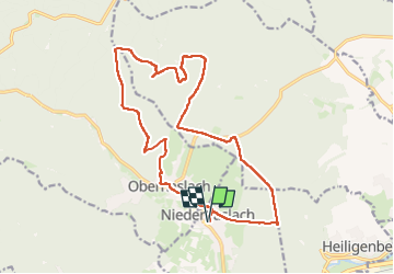
14.9 km | 21 km-effort
4h 46min
Yes
Trail Horseback riding Oberhaslach - Neufeld Boucle Elmersforst - Photo
Horseback riding
GUIDE
holtzv

Horseback riding

Difficult
(1)
Oberhaslach, Grand Est, Bas-Rhin, France
31 km | 42 km-effort
5h 9min
Yes
Trail Mountain bike Niederhaslach - Guirbaden - Grendelbruch - Photo
Mountain bike
tracegps

Mountain bike

Difficult
(1)
Niederhaslach, Grand Est, Bas-Rhin, France
26 km | 35 km-effort
2h 30min
No
Trail Mountain bike Oberhaslach - Rando des Feuilles Mortes - Photo
Mountain bike
tracegps

Mountain bike

Medium
(2)
Oberhaslach, Grand Est, Bas-Rhin, France
29 km | 41 km-effort
2h 0min
Yes
Trail Horseback riding Mollkirch - suuntoapp-HorsebackRiding-2024-04-28T06-24-49Z - Photo
Horseback riding
GUIDE
holtzv

Horseback riding

Difficult
Mollkirch, Grand Est, Bas-Rhin, France
34 km | 48 km-effort
6h 20min
Yes
Trail Horseback riding Niederhaslach - Toutes fugues  - Photo
Horseback riding
feelou

Horseback riding

Easy
(1)
Niederhaslach, Grand Est, Bas-Rhin, France
29 km | 39 km-effort
Unknown
Yes
Trail Horseback riding Mollkirch - 2023-05-28 Picnic CVA Cabane des 5 routes - Photo
Horseback riding
GUIDE
holtzv

Horseback riding

Medium
Mollkirch, Grand Est, Bas-Rhin, France
36 km | 51 km-effort
6h 39min
Yes
Trail Horseback riding Still - 2022-07-10 Picnic CVA Umwurf depuis Oberhaslach - Photo
Horseback riding
GUIDE
holtzv

Horseback riding

Difficult
Still, Grand Est, Bas-Rhin, France
28 km | 40 km-effort
5h 53min
Yes
Trail Walking Oberhaslach - Le Nideck, entre ruines et cascades - Photo
Walking
VacheKiri67

Walking

Difficult
Oberhaslach, Grand Est, Bas-Rhin, France
15.5 km | 24 km-effort
4h 33min
Yes


Close
My subscriptions