Trail Walking Les Houches - J21 - R20 - La Fontaine - La Tour St Michel - Photo

J21 - R20 - La Fontaine - La Tour St Michel

© OpenStreetMap contributors
Length
Length
5 km
Max alt
Max alt
872 m
Uphill gradient
Uphill gradient
98 m
Km-Effort
Km-Effort  
6.3 km
Min alt
Min alt
806 m
Downhill gradient
Downhill gradient
99 m
Boucle
Boucle
Yes
Creation date :
2024-09-21 07:24:08.014
Updated on :
2024-10-01 18:13:49.068

(0 Reviews)

Walking
Walking
1h22
Difficulty : Medium

Scan this QR Code to open this trail in the SityTrail application

FREE GPS app for hiking

Logo SityTrail SityTrail

IGN / Geographical institutes

Download SityTrail from the App Store Download SityTrail from Google Play

Logo SityTrail SityTrail World

The world is yours!

Download SityTrail from the App Store Download SityTrail from Google Play Download SityTrail on Huawei AppGallery

About

Trail Walking of 5 km to be discovered at Auvergne-Rhône-Alpes, Upper Savoy, Les Houches. This trail is proposed by Je vous emmène sur mes chemins .

Description

Château Saint-Michel 860 m.

Ruines d’un château datant d’environ 1300 ayant appartenu à Béatrix de Savoie,dame de Faucigny.
Seules subsistent la tour et une muraille prise dans la verdure.
Ruines entourées des montagnes, la chaîne du Mont-Blanc et celle des Fiz, l'Aiguillette des Houches, le Prarion, ...
www.chamonix.com

Elevation profile

Photos

Positioning

Country:
France
Region :
Auvergne-Rhône-Alpes
Department/Province :
Upper Savoy
Municipality :
Les Houches
Location:
Unknown
Start:(UTM)
327072 ; 5088793 (32T) N.

Trails nearby

Trail Walking Passy - Tour des Ayères - Passy Plaine-Joux - Photo
Walking
tracegps

Walking

Medium
(6)
Passy, Auvergne-Rhône-Alpes, Upper Savoy, France
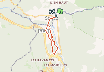
9 km | 14.3 km-effort
2h 30min
Yes
Trail Walking Passy - J10 - R8 - Plaine Joux - Les Ayères - Lac Vert  - Photo
Walking

Walking

Medium
(1)
Passy, Auvergne-Rhône-Alpes, Upper Savoy, France
10.5 km | 16.1 km-effort
3h 4min
Yes
Trail Walking Les Houches - J4 - Les Chavants - Charousse - Vaudagne  - Photo
Walking

Walking

Medium
(1)
Les Houches, Auvergne-Rhône-Alpes, Upper Savoy, France
7.3 km | 11.4 km-effort
2h 10min
Yes
Trail Walking Les Houches - 2024-05-29_17h11m02_christ-roi - Photo
Walking
GUIDE
mumu.larandonneuse

Walking

Easy
(1)
Les Houches, Auvergne-Rhône-Alpes, Upper Savoy, France
1.8 km | 4.2 km-effort
56min
No
Trail Walking Passy - Plaine Joux Barmus Ayères Lac Vert  - Photo
Walking
GUIDE
Kargil

Walking

Very easy
(1)
Passy, Auvergne-Rhône-Alpes, Upper Savoy, France
7.6 km | 12.2 km-effort
2h 18min
Yes
Trail Walking Chamonix-Mont-Blanc - Glacier des Bossons Les Houches Chamonix - Photo
Walking
tracegps

Walking

Difficult
(2)
Chamonix-Mont-Blanc, Auvergne-Rhône-Alpes, Upper Savoy, France
13.1 km | 28 km-effort
5h 0min
Yes
Trail Walking Passy - Plaine Joux-Passage du derochoir-Col de Portette-Platé - Photo
Walking
GUIDE
Kargil

Walking

Difficult
Passy, Auvergne-Rhône-Alpes, Upper Savoy, France
14.4 km | 30 km-effort
6h 42min
Yes
Trail Running Passy - grimpe de chedde ayeres - Photo
Running
winbat11

Running

Very easy
(1)
Passy, Auvergne-Rhône-Alpes, Upper Savoy, France
15 km | 28 km-effort
2h 46min
No
Trail Walking Les Houches - Chalets de Charlousse - Photo
Walking
YannPro81

Walking

Easy
(2)
Les Houches, Auvergne-Rhône-Alpes, Upper Savoy, France
9.2 km | 14.1 km-effort
2h 28min
Yes


Close
My subscriptions