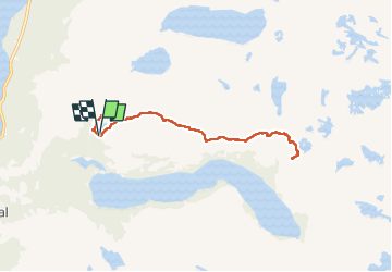
![](/images/other/stat-length.png)
![Trail Walking Unknown - trolltunga - Photo](https://media.geolcdn.com/t/1900/400/5776000a-2eec-4937-8e5a-53aac2c83a4e.jpg&format=pjpeg&maxdim=2)
trolltunga
PVERTICAL
User
![Length](/images/other/stat-length.png)
Length
21 km
![Max alt](https://static1.geolcdn.com/siteimages/upload/files/1508320355ic_sort_altitude_max_24dp.png)
Max alt
1219 m
![Uphill gradient](https://static1.geolcdn.com/siteimages/upload/files/1508320355ic_sort_den_pos_24dp.png)
Uphill gradient
867 m
![Km-Effort](/images/other/stat-length.png)
Km-Effort
32 km
![Min alt](https://static1.geolcdn.com/siteimages/upload/files/1508320355ic_sort_altitude_min_24dp.png)
Min alt
813 m
![Downhill gradient](https://static1.geolcdn.com/siteimages/upload/files/1508320355ic_sort_den_neg_24dp.png)
Downhill gradient
864 m
![Boucle](https://static1.geolcdn.com/siteimages/upload/files/16400158638029165_repeat_loop_refresh_sync_direction_icon.png)
Boucle
Yes
Creation date :
2024-09-20 04:55:00.007
Updated on :
2024-11-04 19:25:54.612
![Walking](https://static1.geolcdn.com/sitytour/trail-icons/101.png)
5h48
Difficulty : Difficult
![Scan this QR Code to open this trail in the SityTrail application](https://capi.geolives.com/qq0zvz2zws4bq2lad0pu/sitytour/trails/4196144/qr.png?size=200)
FREE GPS app for hiking
About
Trail Walking of 21 km to be discovered at Vestland. This trail is proposed by PVERTICAL.
Description
Plusieurs parkings payant possible du P1 le plus éloigné au P3 le plus prêt du départ. Route du P1 au P2 payante accès au P3, environ 76 euros... Places au P3 limitées, réservation obligatoire...https://trolltunga.com/parking-and-transportation/parking/
Très belle randonnée à privilégier tôt le matin et hors saison. en Saisons 1 h d'attente pour faire la photo !
Positioning
Country:
Norway
Region :
Vestland
Department/Province :
Unknown
Municipality :
Unknown
Location:
Unknown
Start:(Dec)
Start:(UTM)
368520 ; 6669401 (32V) N.
Comments
Trails nearby
![Trail On foot - Trolltunga - Photo](https://media.geolcdn.com/t/375/260/f2a120dc-cfd0-4d84-b3d3-5a6975e88807.jpeg&format=jpg&maxdim=2)
![On foot On foot](https://static1.geolcdn.com/sitytour/trail-icons/100.png)
![Trail Walking - Trolltonga (dessous) - Photo](https://media.geolcdn.com/t/375/260/ext.jpg?maxdim=2&url=https%3A%2F%2Fstatic1.geolcdn.com%2Fsiteimages%2Fupload%2Ffiles%2F1553511878bg_sport_marche.png)
![Walking Walking](https://static1.geolcdn.com/sitytour/trail-icons/101.png)
![Trail Walking - Trolltunga to Tyssevassbu - Photo](https://media.geolcdn.com/t/375/260/ext.jpg?maxdim=2&url=https%3A%2F%2Fstatic1.geolcdn.com%2Fsiteimages%2Fupload%2Ffiles%2F1553511878bg_sport_marche.png)
![Walking Walking](https://static1.geolcdn.com/sitytour/trail-icons/101.png)
Trolltunga to Tyssevassbu
Walking
Very difficult
,
Vestland,
,
Norway
![](/images/other/stat-length.png)
17.2 km | 31 km-effort
5h 52min
![](https://static1.geolcdn.com/siteimages/upload/files/16400158638029165_repeat_loop_refresh_sync_direction_icon.png)
No
![Trail Walking - Randonnée de Trolltunga - Photo](https://media.geolcdn.com/t/375/260/ext.jpg?maxdim=2&url=https%3A%2F%2Fstatic1.geolcdn.com%2Fsiteimages%2Fupload%2Ffiles%2F1553511878bg_sport_marche.png)
![Walking Walking](https://static1.geolcdn.com/sitytour/trail-icons/101.png)
![Trail Walking - Trolltunga - Photo](https://media.geolcdn.com/t/375/260/ext.jpg?maxdim=2&url=https%3A%2F%2Fstatic1.geolcdn.com%2Fsiteimages%2Fupload%2Ffiles%2F1553511878bg_sport_marche.png)
![Walking Walking](https://static1.geolcdn.com/sitytour/trail-icons/101.png)
![Trail Walking - Trolltunga - Photo](https://media.geolcdn.com/t/375/260/ext.jpg?maxdim=2&url=https%3A%2F%2Fstatic1.geolcdn.com%2Fsiteimages%2Fupload%2Ffiles%2F1553511878bg_sport_marche.png)
![Walking Walking](https://static1.geolcdn.com/sitytour/trail-icons/101.png)