Trail Walking Thuir - THUIR 66 - chapelle VILARMILA - Vinyer Capella, Rei - Photo

THUIR 66 - chapelle VILARMILA - Vinyer Capella, Rei

 jeff66
jeff66

User

© OpenStreetMap contributors
Length
Length
10.1 km
Max alt
Max alt
105 m
Uphill gradient
Uphill gradient
45 m
Km-Effort
Km-Effort  
10.7 km
Min alt
Min alt
84 m
Downhill gradient
Downhill gradient
45 m
Boucle
Boucle
Yes
Creation date :
2015-05-12 00:00:00.0
Updated on :
2015-05-12 00:00:00.0

(4 Reviews)

Walking
Walking
1h39
Difficulty : Easy

Scan this QR Code to open this trail in the SityTrail application

FREE GPS app for hiking

Logo SityTrail SityTrail

IGN / Geographical institutes

Download SityTrail from the App Store Download SityTrail from Google Play

Logo SityTrail SityTrail World

The world is yours!

Download SityTrail from the App Store Download SityTrail from Google Play Download SityTrail on Huawei AppGallery

About

Trail Walking of 10.1 km to be discovered at Occitania, Pyrénées-Orientales, Thuir. This trail is proposed by jeff66.

Description

THUIR 66 - LLUPIA - piste cyclable - centre équitation - base ULM - chapelle de VILARMILA - Vinyer de la Capella - Vinyer del Rei - l'Adou

Elevation profile

Photos

Positioning

Country:
France
Region :
Occitania
Department/Province :
Pyrénées-Orientales
Municipality :
Thuir
Location:
Unknown
Start:(UTM)
481892 ; 4721299 (31T) N.

Comments

Please log in to post a review or rate the element


Trails nearby

Trail Walking Llupia - 66 LLUPIA - FOURQUES - TERRATS promenade dans les ASPRES et son vignoble  - Photo
Walking
jeff66

Walking

Medium
(1)
Llupia, Occitania, Pyrénées-Orientales, France
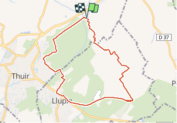
15 km | 18.2 km-effort
2h 36min
Yes
Trail Walking Thuir - Thuir à Castelnou - Photo
Walking
timousse

Walking

Medium
(1)
Thuir, Occitania, Pyrénées-Orientales, France
14.1 km | 20 km-effort
4h 13min
Yes
Trail Walking Sainte-Colombe-de-la-Commanderie - THUIR 66 - Castelnou - Ste Colombe de la C. - Photo
Walking
jeff66

Walking

Medium
(2)
Sainte-Colombe-de-la-Commanderie, Occitania, Pyrénées-Orientales, France
14.8 km | 21 km-effort
2h 56min
Yes
Trail Mountain bike Canohès - canohes - Photo
Mountain bike
haroldtheviking

Mountain bike

Medium
(2)
Canohès, Occitania, Pyrénées-Orientales, France
37 km | 44 km-effort
2h 12min
Yes
Trail Walking Sainte-Colombe-de-la-Commanderie - 20230316 Sté Colombe-Castelnou - Photo
Walking
ThonyM

Walking

Medium
Sainte-Colombe-de-la-Commanderie, Occitania, Pyrénées-Orientales, France
16.3 km | 23 km-effort
3h 55min
Yes
Trail Running Saint-Féliu-d'Avall - Boucle St Feliu Amont -Ill sur Tête  - Photo
Running
zazie

Running

Medium
(1)
Saint-Féliu-d'Avall, Occitania, Pyrénées-Orientales, France
23 km | 25 km-effort
2h 8min
No
Trail Walking Saint-Féliu-d'Avall - 66 ST-FELIU-D'AVALL, CORNEILLA DE LA RIVIERE, promenade autour de la Têt - Photo
Walking
jeff66

Walking

Easy
Saint-Féliu-d'Avall, Occitania, Pyrénées-Orientales, France
6.6 km | 7 km-effort
1h 16min
Yes
Trail Walking Le Soler - 66 LE SOLER - ST FELIU D'AVALL, promenade le long du Rau du SOLER et de la rivière de CASTELNOU entre canaux et vergers - Photo
Walking
jeff66

Walking

Easy
Le Soler, Occitania, Pyrénées-Orientales, France
9.8 km | 10.4 km-effort
1h 39min
Yes
Trail Walking Le Soler - 66 LE SOLER - TOULOUGES, village, jardins, vergers, canaux et la Basse - Photo
Walking
jeff66

Walking

Medium
Le Soler, Occitania, Pyrénées-Orientales, France
13.5 km | 14.3 km-effort
2h 15min
Yes


Close
My subscriptions