Trail Hybrid bike Yerres - Yerres Verrerie reconnu - Photo

Yerres Verrerie reconnu

© OpenStreetMap contributors
Length
Length
42 km
Max alt
Max alt
95 m
Uphill gradient
Uphill gradient
379 m
Km-Effort
Km-Effort  
47 km
Min alt
Min alt
29 m
Downhill gradient
Downhill gradient
408 m
Boucle
Boucle
No
Creation date :
2024-09-18 10:02:44.463
Updated on :
2024-09-18 15:57:42.066

(0 Reviews)

Hybrid bike
Hybrid bike
3h07
Difficulty : Very difficult

Scan this QR Code to open this trail in the SityTrail application

FREE GPS app for hiking

Logo SityTrail SityTrail

IGN / Geographical institutes

Download SityTrail from the App Store Download SityTrail from Google Play

Logo SityTrail SityTrail World

The world is yours!

Download SityTrail from the App Store Download SityTrail from Google Play Download SityTrail on Huawei AppGallery

About

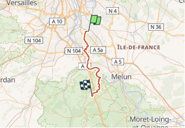
Trail Hybrid bike of 42 km to be discovered at Ile-de-France, Essonne, Yerres. This trail is proposed by Catherine de Brunoy.

Description

Par Sénart, Corbeil St Fargeau 15km long Seine. Puis passages Forêt et chemins de champs qq
côtes ms faisables.
4h

Elevation profile

Photos

Points of interest

Point of interest Pringy - Unnamed POI - Photo
Catherine de Brunoy
PRINGY 
Point of interest Étiolles - Unnamed POI - Photo
Catherine de Brunoy
ÉTIOLLES 

Positioning

Country:
France
Region :
Ile-de-France
Department/Province :
Essonne
Municipality :
Yerres
Location:
Unknown
Start:(UTM)
462184 ; 5394370 (31U) N.

Trails nearby

Trail On foot Villecresnes - L 20  boucle golf villecresnes et ancienne voie de chemin de fer - Photo
On foot

On foot

Easy
(6)
Villecresnes, Ile-de-France, Val-de-Marne, France
7.7 km | 8.9 km-effort
2h 0min
Yes
Trail Walking Boussy-Saint-Antoine - GRP CV-IDF 04 - Photo
Walking
clalaur

Walking

Difficult
(1)
Boussy-Saint-Antoine, Ile-de-France, Essonne, France
16.8 km | 18.6 km-effort
4h 13min
No
Trail Walking Mandres-les-Roses - J 26 Mandres, Boussy , Brunoy le chemin des fresques  - Photo
Walking

Walking

Medium
(2)
Mandres-les-Roses, Ile-de-France, Val-de-Marne, France
12.2 km | 13.8 km-effort
3h 7min
Yes
Trail Walking Yerres - BM Foret Regionale de Grobois 10km - Photo
Walking
GUIDE
jeanmarcMasson

Walking

Medium
(1)
Yerres, Ile-de-France, Essonne, France
10.4 km | 11 km-effort
2h 30min
Yes
Trail Walking Yerres - BM Foret Regionale Grosbois 10km - Photo
Walking
GUIDE
jeanmarcMasson

Walking

Medium
(1)
Yerres, Ile-de-France, Essonne, France
9.8 km | 10.5 km-effort
2h 23min
Yes
Trail On foot Brunoy - L 39 Brunoy, les bords de l'Yerres - Photo
On foot

On foot

Very easy
(4)
Brunoy, Ile-de-France, Essonne, France
5.4 km | 6.1 km-effort
1h 49min
Yes
Trail Walking Montgeron - J 38 Montgeron la Pelouse, forêt de Sénart - Photo
Walking

Walking

Difficult
(3)
Montgeron, Ile-de-France, Essonne, France
12.4 km | 13.3 km-effort
3h 1min
Yes
Trail On foot Quincy-sous-Sénart - J 77 Tigery, Allée Royale - Photo
On foot

On foot

Medium
(3)
Quincy-sous-Sénart, Ile-de-France, Essonne, France
10.6 km | 12 km-effort
2h 44min
Yes
Trail On foot Boussy-Saint-Antoine - L 32: Boussy St Antoine l'Yerres et le Gord - Photo
On foot

On foot

Very easy
(3)
Boussy-Saint-Antoine, Ile-de-France, Essonne, France
6.2 km | 7.2 km-effort
1h 38min
Yes


Close
My subscriptions