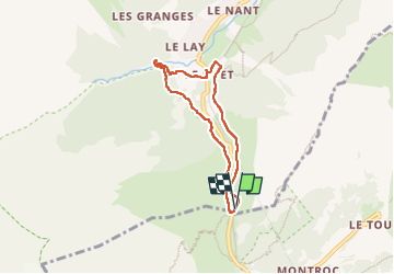
Trail Walking Vallorcine - J18 - R17 - Col des Montets - Cascade de Bérard - Photo

J18 - R17 - Col des Montets - Cascade de Bérard

© OpenStreetMap contributors
Length
Length
6.1 km
Max alt
Max alt
1473 m
Uphill gradient
Uphill gradient
203 m
Km-Effort
Km-Effort  
8.7 km
Min alt
Min alt
1337 m
Downhill gradient
Downhill gradient
200 m
Boucle
Boucle
Yes
Creation date :
2024-09-18 08:46:23.417
Updated on :
2024-10-01 18:10:48.941

(1 Reviews)

Walking
Walking
1h57
Difficulty : Medium

Scan this QR Code to open this trail in the SityTrail application

FREE GPS app for hiking

Logo SityTrail SityTrail

IGN / Geographical institutes

Download SityTrail from the App Store Download SityTrail from Google Play

Logo SityTrail SityTrail World

The world is yours!

Download SityTrail from the App Store Download SityTrail from Google Play Download SityTrail on Huawei AppGallery

About

Trail Walking of 6.1 km to be discovered at Auvergne-Rhône-Alpes, Upper Savoy, Vallorcine. This trail is proposed by Je vous emmène sur mes chemins .

Description

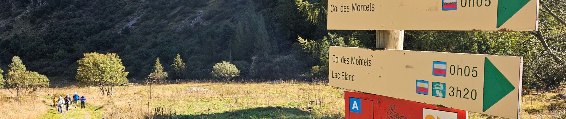
Une promenade dans la réserve naturelle des Aiguilles Rouges et dans le vallon de Bérard pour découvrir la cascade formée par un tumultueux torrent qui dévale les pentes des Aiguilles Rouges près du typique hameau de la Poya, autrefois abris des chevriers du village.
On y découvre également la Grotte à Farinet.

🍽☕️🍺 La Buvette La Cascade

🐕 interdit

🅿️ et arrêt de 🚌 au départ

Elevation profile

Photos

38 photos in total. Please click on a photo to see them all in the gallery.

Positioning

Country:
France
Region :
Auvergne-Rhône-Alpes
Department/Province :
Upper Savoy
Municipality :
Vallorcine
Location:
Unknown
Start:(UTM)
339269 ; 5096641 (32T) N.

Comments

Please log in to post a review or rate the element


J22 - R22 - Refaite avec les filles.


Trails nearby

Trail Walking Vallorcine - Le Buet - Vallorcine - Photo
Walking
tracegps

Walking

Difficult
(1)
Vallorcine, Auvergne-Rhône-Alpes, Upper Savoy, France
9 km | 27 km-effort
7h 0min
No
Trail Walking Chamonix-Mont-Blanc - Aiguillette des Posettes 2201m 6.7.22 - Photo
Walking
GUIDE
fredetpascale

Walking

Easy
Chamonix-Mont-Blanc, Auvergne-Rhône-Alpes, Upper Savoy, France
8.4 km | 17.8 km-effort
3h 30min
Yes
Trail Winter sports Vallorcine - vers Finhaut - Photo
Winter sports
fpitance

Winter sports

Medium
(1)
Vallorcine, Auvergne-Rhône-Alpes, Upper Savoy, France
22 km | 40 km-effort
5h 0min
No
Trail Walking Vallorcine - J16 - R15 - Chemin des Diligences - Photo
Walking

Walking

Medium
Vallorcine, Auvergne-Rhône-Alpes, Upper Savoy, France
11.1 km | 15.5 km-effort
3h 15min
Yes
Trail Walking Chamonix-Mont-Blanc - Argentiere - Photo
Walking
michauxpaul

Walking

Difficult
Chamonix-Mont-Blanc, Auvergne-Rhône-Alpes, Upper Savoy, France
5.9 km | 12.7 km-effort
4h 23min
No
Trail Walking Chamonix-Mont-Blanc - Le tour des Aiguilles Rouges : J3 - Photo
Walking
Greg813

Walking

Medium
Chamonix-Mont-Blanc, Auvergne-Rhône-Alpes, Upper Savoy, France
10.5 km | 19.4 km-effort
3h 13min
No
Trail Walking Vallorcine - Le tour des Aiguilles Rouges : J1 - Photo
Walking
Greg813

Walking

Very difficult
Vallorcine, Auvergne-Rhône-Alpes, Upper Savoy, France
16 km | 32 km-effort
5h 2min
No
Trail Walking Chamonix-Mont-Blanc - J11 - R9 - Montroc - Le Tour - Petit Balcon Nord  - Photo
Walking

Walking

Medium
Chamonix-Mont-Blanc, Auvergne-Rhône-Alpes, Upper Savoy, France
6.2 km | 9.5 km-effort
1h 59min
Yes
Trail Walking Chamonix-Mont-Blanc - Randonnée dans la Vallée de Chamonix - Photo
Walking
jeff2

Walking

Easy
Chamonix-Mont-Blanc, Auvergne-Rhône-Alpes, Upper Savoy, France
12.5 km | 15.3 km-effort
3h 13min
No


Close
My subscriptions