Trail Walking Les Rousses - Bief de la Chaille par les Milpas - Photo

Bief de la Chaille par les Milpas

© OpenStreetMap contributors
Length
Length
9.5 km
Max alt
Max alt
1159 m
Uphill gradient
Uphill gradient
226 m
Km-Effort
Km-Effort  
12.5 km
Min alt
Min alt
1011 m
Downhill gradient
Downhill gradient
228 m
Boucle
Boucle
Yes
Creation date :
2024-09-18 08:15:58.489
Updated on :
2024-09-25 19:21:28.639

(0 Reviews)

Walking
Walking
3h19
Difficulty : Difficult

Scan this QR Code to open this trail in the SityTrail application

FREE GPS app for hiking

Logo SityTrail SityTrail

IGN / Geographical institutes

Download SityTrail from the App Store Download SityTrail from Google Play

Logo SityTrail SityTrail World

The world is yours!

Download SityTrail from the App Store Download SityTrail from Google Play Download SityTrail on Huawei AppGallery

About

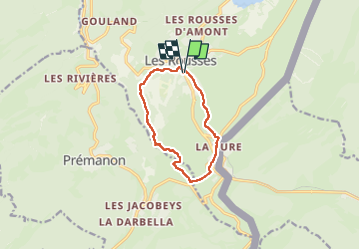
Trail Walking of 9.5 km to be discovered at Bourgogne-Franche-Comté, Jura, Les Rousses. This trail is proposed by pascalmilpas.

Description

PK à l'OT des Rousses, tour du Fort coté NO puis descente dans la vallée de la Chaille, avant de remonter vers la Grenotte
Zone très urbaine autour des postes frontières = attention aux routes et aux traversées
Puis retour facile et agréable au milieu des pâtures et des foins ...

Elevation profile

Positioning

Country:
France
Region :
Bourgogne-Franche-Comté
Department/Province :
Jura
Municipality :
Les Rousses
Location:
Unknown
Start:(UTM)
274455 ; 5151837 (32T) N.

Trails nearby

Trail Cycle  - Lac de Lamoura et Valserine - Prémanon - Photo
Cycle
tracegps

Cycle

Medium
(1)
, Bourgogne-Franche-Comté, Jura, France
39 km | 49 km-effort
2h 0min
Yes
Trail Walking  - Le Belvédère des Maquisards - Prémanon - Photo
Walking
tracegps

Walking

Medium
(1)
, Bourgogne-Franche-Comté, Jura, France
5.4 km | 7.8 km-effort
2h 0min
Yes
Trail Walking  - Autour de Prémanon - Photo
Walking
tracegps

Walking

Very difficult
(1)
, Bourgogne-Franche-Comté, Jura, France
18 km | 27 km-effort
6h 0min
Yes
Trail Walking Les Rousses - Le Noirmont - Les Rousses - Photo
Walking
tracegps

Walking

Very difficult
(2)
Les Rousses, Bourgogne-Franche-Comté, Jura, France
15.1 km | 23 km-effort
6h 0min
Yes
Trail Walking Prémanon - dole1 - Photo
Walking
fredj

Walking

Very easy
(2)
Prémanon, Bourgogne-Franche-Comté, Jura, France
6.6 km | 12.5 km-effort
1h 49min
Yes
Trail On foot  - Les Arcets - Photo
On foot
GUIDE+

On foot

Easy
, Bourgogne-Franche-Comté, Jura, France
9 km | 13.6 km-effort
3h 5min
Yes
Trail Walking  - Prémanon, Mont Fier  - Photo
Walking
MoiClaude

Walking

Very easy
(1)
, Bourgogne-Franche-Comté, Jura, France
10.9 km | 15.8 km-effort
2h 34min
No
Trail Snowshoes Les Rousses - Lac des Rousses  - Photo
Snowshoes
nfranche

Snowshoes

Medium
(1)
Les Rousses, Bourgogne-Franche-Comté, Jura, France
13.8 km | 18.4 km-effort
4h 15min
Yes
Trail Walking Les Rousses - Noirmont et Creux du Croue - Photo
Walking
DanElise

Walking

Very easy
(1)
Les Rousses, Bourgogne-Franche-Comté, Jura, France
12.2 km | 19.8 km-effort
4h 18min
Yes


Close
My subscriptions