Trail Walking Vitry-le-François - via Columbani 12 du 29.08.2024 - Photo

via Columbani 12 du 29.08.2024

© OpenStreetMap contributors
Length
Length
22 km
Max alt
Max alt
151 m
Uphill gradient
Uphill gradient
200 m
Km-Effort
Km-Effort  
24 km
Min alt
Min alt
93 m
Downhill gradient
Downhill gradient
195 m
Boucle
Boucle
No
Creation date :
2024-08-29 08:27:05.493
Updated on :
2024-09-18 05:12:12.037

(0 Reviews)

Walking
Walking
6h45
Difficulty : Easy

Scan this QR Code to open this trail in the SityTrail application

FREE GPS app for hiking

Logo SityTrail SityTrail

IGN / Geographical institutes

Download SityTrail from the App Store Download SityTrail from Google Play

Logo SityTrail SityTrail World

The world is yours!

Download SityTrail from the App Store Download SityTrail from Google Play Download SityTrail on Huawei AppGallery

About

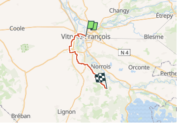
Trail Walking of 22 km to be discovered at Grand Est, Marne, Vitry-le-François. This trail is proposed by bene_dictus77.

Description

de Vitry LF à St Rémy en Bouzemont

Elevation profile

Positioning

Country:
France
Region :
Grand Est
Department/Province :
Marne
Municipality :
Vitry-le-François
Location:
Unknown
Start:(UTM)
616596 ; 5398172 (31U) N.

Trails nearby

Trail Walking Vitry-en-Perthois - vitry en perthois vitry le francois - Photo
Walking
ghislaine61

Walking

Easy
Vitry-en-Perthois, Grand Est, Marne, France
12.1 km | 12.8 km-effort
3h 45min
Yes
Trail Walking Loisy-sur-Marne - Loisy - Photo
Walking
JD51290

Walking

Very easy
(1)
Loisy-sur-Marne, Grand Est, Marne, France
13.2 km | 14.4 km-effort
3h 0min
No
Trail Walking Vitry-le-François - La Via Francigena - Vitry le François - Brienne le Château - Photo
Walking
tracegps

Walking

Medium
(1)
Vitry-le-François, Grand Est, Marne, France
79 km | 89 km-effort
16h 0min
No
Trail On foot Vitry-en-Perthois - Circuit du Mont de Fourche - Photo
On foot
GUIDE+

On foot

Easy
Vitry-en-Perthois, Grand Est, Marne, France
5 km | 6 km-effort
1h 21min
No
Trail On foot Loisy-sur-Marne - Parcours Violet - Photo
On foot
GUIDE+

On foot

Easy
Loisy-sur-Marne, Grand Est, Marne, France
4.8 km | 5.3 km-effort
1h 11min
Yes
Trail On foot Loisy-sur-Marne - Parcours Vert - Photo
On foot
GUIDE+

On foot

Easy
Loisy-sur-Marne, Grand Est, Marne, France
5.4 km | 5.8 km-effort
1h 19min
Yes
Trail On foot Loisy-sur-Marne - Parcours Rouge - Photo
On foot
GUIDE+

On foot

Easy
Loisy-sur-Marne, Grand Est, Marne, France
10.6 km | 11.7 km-effort
2h 39min
No
Trail On foot Loisy-sur-Marne - Parcours Rose - Photo
On foot
GUIDE+

On foot

Easy
Loisy-sur-Marne, Grand Est, Marne, France
4.7 km | 4.9 km-effort
1h 7min
No
Trail On foot Loisy-sur-Marne - Parcours Bleu - Photo
On foot
GUIDE+

On foot

Easy
Loisy-sur-Marne, Grand Est, Marne, France
6.8 km | 7.2 km-effort
1h 38min
No


Close
My subscriptions