![](/images/other/stat-length.png)
![Trail Walking Soisy-sur-École - Soisy-sur-Ecole - Tertres - Photo](https://media.geolcdn.com/t/1900/400/f1ae2235-ac3a-4274-b705-36c8bd8b6282.jpg&format=pjpeg&maxdim=2)
Soisy-sur-Ecole - Tertres
guydu41
User
![Length](/images/other/stat-length.png)
![Max alt](https://static1.geolcdn.com/siteimages/upload/files/1508320355ic_sort_altitude_max_24dp.png)
![Uphill gradient](https://static1.geolcdn.com/siteimages/upload/files/1508320355ic_sort_den_pos_24dp.png)
![Km-Effort](/images/other/stat-length.png)
![Min alt](https://static1.geolcdn.com/siteimages/upload/files/1508320355ic_sort_altitude_min_24dp.png)
![Downhill gradient](https://static1.geolcdn.com/siteimages/upload/files/1508320355ic_sort_den_neg_24dp.png)
![Boucle](https://static1.geolcdn.com/siteimages/upload/files/16400158638029165_repeat_loop_refresh_sync_direction_icon.png)
![Walking](https://static1.geolcdn.com/sitytour/trail-icons/101.png)
2h36
Difficulty : Medium
![Scan this QR Code to open this trail in the SityTrail application](https://capi.geolives.com/qq0zvz2zws4bq2lad0pu/sitytour/trails/4193200/qr.png?size=200)
FREE GPS app for hiking
About
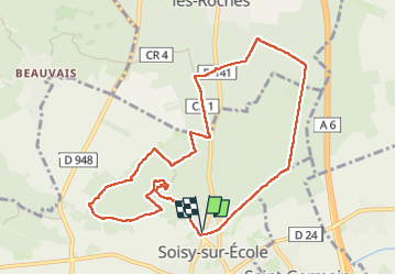
Trail Walking of 9.9 km to be discovered at Ile-de-France, Essonne, Soisy-sur-École. This trail is proposed by guydu41.
Description
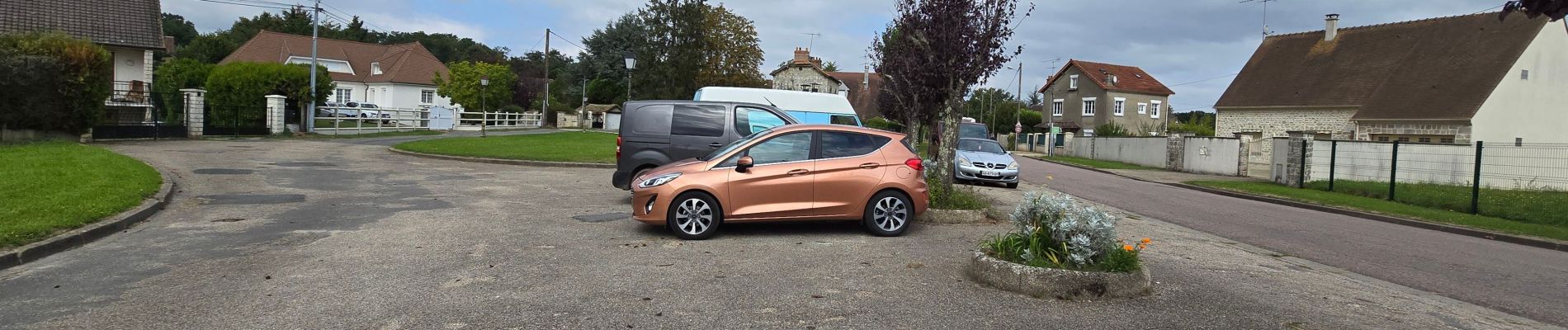
Ce circuit en sens horaire démarre depuis un parking 3 Rue de Corbeil, 91840 Soisy-sur-École.
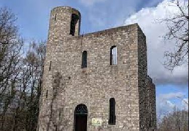
Au bout de 800 m, le parcours arrive au pied du Tertre Blanc. Ce monticule rocheux que l’on peut gravir offre un point de vue sur la forêt environnante.
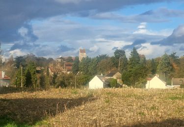
Le reste du circuit emprunte des chemins et des sentiers sans difficultés dans les bois au Nord de la ville.
Positioning
Comments
Trails nearby
![Trail On foot Saint-Germain-sur-École - Boucle Soisy Sur Ecole - Photo](https://media.geolcdn.com/t/375/260/191519f5-31af-4b92-abf3-6dc57900b32f.jpg&format=jpg&maxdim=2)
![On foot On foot](https://static1.geolcdn.com/sitytour/trail-icons/100.png)
On foot
![](/images/other/stat-length.png)
![](https://static1.geolcdn.com/siteimages/upload/files/16400158638029165_repeat_loop_refresh_sync_direction_icon.png)
![Trail Walking Champcueil - JC 51 - 18,4 km - 320m - Champcueil, Les Grands Avaux - 23 km Effort - Photo](https://media.geolcdn.com/t/375/260/489ffccc-38be-45b9-b302-6ec46034b0a7.jpg&format=jpg&maxdim=2)
![Walking Walking](https://static1.geolcdn.com/sitytour/trail-icons/101.png)
Walking
![](/images/other/stat-length.png)
![](https://static1.geolcdn.com/siteimages/upload/files/16400158638029165_repeat_loop_refresh_sync_direction_icon.png)
![Trail Walking Saint-Germain-sur-École - Boucle soisy version definitif - Photo](https://media.geolcdn.com/t/375/260/393daa89-85e9-457d-aec1-026a61438d59.jpg&format=jpg&maxdim=2)
![Walking Walking](https://static1.geolcdn.com/sitytour/trail-icons/101.png)
Walking
![](/images/other/stat-length.png)
![](https://static1.geolcdn.com/siteimages/upload/files/16400158638029165_repeat_loop_refresh_sync_direction_icon.png)
![Trail On foot Champcueil - Boucle Beauvais 28 km - Photo](https://media.geolcdn.com/t/375/260/e36d05bc-8349-4259-9130-b9f8c6d20d01.jpg&format=jpg&maxdim=2)
![On foot On foot](https://static1.geolcdn.com/sitytour/trail-icons/100.png)
On foot
![](/images/other/stat-length.png)
![](https://static1.geolcdn.com/siteimages/upload/files/16400158638029165_repeat_loop_refresh_sync_direction_icon.png)
![Trail Walking Champcueil - Boucle Champcueil - Photo](https://media.geolcdn.com/t/375/260/7fb1af8d-34a9-45ce-aaee-3ffb4d1f1fed.jpg&format=jpg&maxdim=2)
![Walking Walking](https://static1.geolcdn.com/sitytour/trail-icons/101.png)
Walking
![](/images/other/stat-length.png)
![](https://static1.geolcdn.com/siteimages/upload/files/16400158638029165_repeat_loop_refresh_sync_direction_icon.png)
![Trail Walking Saint-Germain-sur-École - Autour de Soisy sur Ecole - Boucle 30 km - Photo](https://media.geolcdn.com/t/375/260/42a45b0a-7dbc-4142-a18c-2c21a7c16f7f.jpg&format=jpg&maxdim=2)
![Walking Walking](https://static1.geolcdn.com/sitytour/trail-icons/101.png)
Walking
![](/images/other/stat-length.png)
![](https://static1.geolcdn.com/siteimages/upload/files/16400158638029165_repeat_loop_refresh_sync_direction_icon.png)
![Trail On foot Champcueil - Balade entre Brie de Gâtinais - Photo](https://media.geolcdn.com/t/375/260/b0136ac0-b10f-482a-a588-87ed1c582c80.jpeg&format=jpg&maxdim=2)
![On foot On foot](https://static1.geolcdn.com/sitytour/trail-icons/100.png)
On foot
![](/images/other/stat-length.png)
![](https://static1.geolcdn.com/siteimages/upload/files/16400158638029165_repeat_loop_refresh_sync_direction_icon.png)
![Trail Walking Saint-Sauveur-sur-École - Autour de St Sauveur l'Ecole - Photo](https://media.geolcdn.com/t/375/260/60d05cfc-695b-4981-a344-8a4aca4564fc.jpg&format=jpg&maxdim=2)
![Walking Walking](https://static1.geolcdn.com/sitytour/trail-icons/101.png)
Walking
![](/images/other/stat-length.png)
![](https://static1.geolcdn.com/siteimages/upload/files/16400158638029165_repeat_loop_refresh_sync_direction_icon.png)
![Trail Walking Champcueil - Grands Avaux - Tertre blanc (Nainville) - fait - Photo](https://media.geolcdn.com/t/375/260/ext.jpg?maxdim=2&url=https%3A%2F%2Fstatic1.geolcdn.com%2Fsiteimages%2Fupload%2Ffiles%2F1553511878bg_sport_marche.png)
![Walking Walking](https://static1.geolcdn.com/sitytour/trail-icons/101.png)
Walking
![](/images/other/stat-length.png)
![](https://static1.geolcdn.com/siteimages/upload/files/16400158638029165_repeat_loop_refresh_sync_direction_icon.png)