Trail On foot Laveissière - font de cere bec de l' aigle  col de renonder  - Photo

font de cere bec de l' aigle col de renonder

 acdcu
acdcu

User

© OpenStreetMap contributors
Length
Length
8.8 km
Max alt
Max alt
1685 m
Uphill gradient
Uphill gradient
587 m
Km-Effort
Km-Effort  
16.6 km
Min alt
Min alt
1197 m
Downhill gradient
Downhill gradient
579 m
Boucle
Boucle
Yes
Creation date :
2024-09-17 10:29:23.566
Updated on :
2024-09-17 11:55:55.599

(1 Reviews)

On foot
On foot
3h46
Difficulty : Easy
Walking
Walking
3h46
Difficulty : Medium

Scan this QR Code to open this trail in the SityTrail application

FREE GPS app for hiking

Logo SityTrail SityTrail

IGN / Geographical institutes

Download SityTrail from the App Store Download SityTrail from Google Play

Logo SityTrail SityTrail World

The world is yours!

Download SityTrail from the App Store Download SityTrail from Google Play Download SityTrail on Huawei AppGallery

About

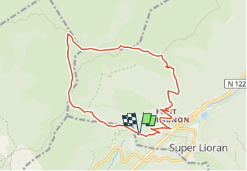
Trail On foot of 8.8 km to be discovered at Auvergne-Rhône-Alpes, Cantal, Laveissière. This trail is proposed by acdcu.

Description

Petite randonnée sympa à faire de 8 km.  
Prenez la direction du font Alagnon et montez au bec de l'Aigle.  
Attention à la montée du bec de l'Aigle, qui est délicate.  
Ensuite, continuez sur les crêtes ; vous atteindrez deux sommets : le Téton de Vénus et le Puy de Batallouise. Ensuite, redescendez sur le col de Cabre.  
Traversez le col du Renonder et descendez ensuite au fond de Cère, où vous trouverez votre arrivé

Elevation profile

Photos

Positioning

Country:
France
Region :
Auvergne-Rhône-Alpes
Department/Province :
Cantal
Municipality :
Laveissière
Location:
Unknown
Start:(UTM)
479098 ; 4992468 (31T) N.

Comments

Please log in to post a review or rate the element


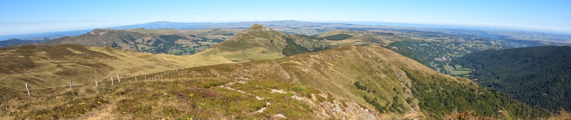
extra comme randonnée.


Trails nearby

Trail Walking Albepierre-Bredons - Cantal - Col de Prat de Bouc Le Plomb du Cantal - 8.2km 450m 2h45 - 2019 07 06 - Photo
Walking
GUIDE
Orcal37

Walking

Medium
(1)
Albepierre-Bredons, Auvergne-Rhône-Alpes, Cantal, France
8.2 km | 14.2 km-effort
2h 45min
Yes
Trail Walking Laveissière - Le Puy Griou de Super Lioran - Photo
Walking
tracegps

Walking

Medium
(2)
Laveissière, Auvergne-Rhône-Alpes, Cantal, France
11.9 km | 19.7 km-effort
5h 0min
Yes
Trail Walking Laveissière - Le plomb du Cantal - Le Lioran - Photo
Walking
tracegps

Walking

Medium
(1)
Laveissière, Auvergne-Rhône-Alpes, Cantal, France
14.4 km | 27 km-effort
6h 0min
Yes
Trail Walking Laveissière - Les crêtes du Cantal - Le Lioran - Photo
Walking
tracegps

Walking

Difficult
(4)
Laveissière, Auvergne-Rhône-Alpes, Cantal, France
28 km | 51 km-effort
7h 30min
Yes
Trail Walking Laveissière - le Peyre Arse - Le Lioran - Photo
Walking
tracegps

Walking

Difficult
(1)
Laveissière, Auvergne-Rhône-Alpes, Cantal, France
11.2 km | 19.4 km-effort
4h 0min
No
Trail Walking Laveissière - Lioran 2023-08-18 Col de Rombière Col du Pertus A/R - Photo
Walking
marionneau

Walking

Easy
(1)
Laveissière, Auvergne-Rhône-Alpes, Cantal, France
12.5 km | 18.8 km-effort
4h 14min
Yes
Trail Walking Laveissière - Lioran 2023-08-11 Col du Pertus - Photo
Walking
marionneau

Walking

Medium
(1)
Laveissière, Auvergne-Rhône-Alpes, Cantal, France
17.3 km | 25 km-effort
2h 57min
Yes
Trail Walking Laveissière - Lioran 2023-08-09 Puy de Seycheuse - Photo
Walking
marionneau

Walking

Very difficult
(1)
Laveissière, Auvergne-Rhône-Alpes, Cantal, France
13.9 km | 23 km-effort
5h 20min
Yes
Trail Trail Laveissière - Puy de Peyre Arse/ Puy Bataillouse / Téton de Vénus et Rocher du bec de l'aigle  - Photo
Trail
GUIDE
nadd73

Trail

Medium
Laveissière, Auvergne-Rhône-Alpes, Cantal, France
12.8 km | 25 km-effort
3h 4min
Yes


Close
My subscriptions