Trail Walking Maraye-en-Othe - Balade aux Boulins - Photo

Balade aux Boulins

 FPortier
FPortier

User

© OpenStreetMap contributors
Length
Length
9.9 km
Max alt
Max alt
295 m
Uphill gradient
Uphill gradient
140 m
Km-Effort
Km-Effort  
11.8 km
Min alt
Min alt
215 m
Downhill gradient
Downhill gradient
141 m
Boucle
Boucle
Yes
Creation date :
2024-09-17 06:48:10.136
Updated on :
2024-09-17 09:53:57.917

(0 Reviews)

Walking
Walking
3h04
Difficulty : Medium

Scan this QR Code to open this trail in the SityTrail application

FREE GPS app for hiking

Logo SityTrail SityTrail

IGN / Geographical institutes

Download SityTrail from the App Store Download SityTrail from Google Play

Logo SityTrail SityTrail World

The world is yours!

Download SityTrail from the App Store Download SityTrail from Google Play Download SityTrail on Huawei AppGallery

About

Trail Walking of 9.9 km to be discovered at Grand Est, Aube, Maraye-en-Othe. This trail is proposed by FPortier.

Description

Randonnée du 17 septembre 2024

Elevation profile

Photos

Positioning

Country:
France
Region :
Grand Est
Department/Province :
Aube
Municipality :
Maraye-en-Othe
Location:
Unknown
Start:(UTM)
564929 ; 5335005 (31U) N.

Trails nearby

Trail Walking Bercenay-en-Othe - Bercenay - Photo
Walking
FPortier

Walking

Medium
Bercenay-en-Othe, Grand Est, Aube, France
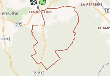
9.2 km | 12.2 km-effort
2h 24min
Yes
Trail Walking Maraye-en-Othe - Les Boulins - Photo
Walking
FPortier

Walking

Easy
Maraye-en-Othe, Grand Est, Aube, France
8.9 km | 10.8 km-effort
2h 21min
Yes
Trail Walking Maraye-en-Othe - Maraye (11+13km) le 21/07/2020 - Photo
Walking
francis1952

Walking

Medium
Maraye-en-Othe, Grand Est, Aube, France
25 km | 30 km-effort
5h 14min
Yes
Trail Cycle Bercenay-en-Othe - Circuit de Bercenay-en-Othe  - Photo
Cycle
tracegps

Cycle

Easy
Bercenay-en-Othe, Grand Est, Aube, France
27 km | 32 km-effort
1h 30min
Yes
Trail Walking Eaux-Puiseaux - Circuit des trois Monts - Eaux-Puiseaux - Photo
Walking
tracegps

Walking

Very difficult
Eaux-Puiseaux, Grand Est, Aube, France
14.7 km | 19 km-effort
3h 45min
Yes
Trail Walking Maraye-en-Othe - Le circuit des Voirloups - Maraye-en-Othe - Photo
Walking
tracegps

Walking

Very difficult
(1)
Maraye-en-Othe, Grand Est, Aube, France
19.1 km | 24 km-effort
4h 49min
Yes
Trail Walking Maraye-en-Othe - Les Vergers de Champcharme - Maraye-en-Othe - Photo
Walking
tracegps

Walking

Difficult
Maraye-en-Othe, Grand Est, Aube, France
14.3 km | 18.6 km-effort
3h 34min
Yes
Trail Walking Bercenay-en-Othe - Circuit de Bercenay en Othe - Photo
Walking
tracegps

Walking

Medium
Bercenay-en-Othe, Grand Est, Aube, France
10.1 km | 12.7 km-effort
2h 30min
Yes
Trail Walking Maraye-en-Othe - Maraye 29km le 27.05.2024 - Photo
Walking
francis1952

Walking

Difficult
Maraye-en-Othe, Grand Est, Aube, France
29 km | 37 km-effort
6h 10min
Yes


Close
My subscriptions