Trail Walking Wildenstein - Trek alsacien (boucle de Wildenstein) - Photo

Trek alsacien (boucle de Wildenstein)

© OpenStreetMap contributors
Length
Length
15.4 km
Max alt
Max alt
1105 m
Uphill gradient
Uphill gradient
625 m
Km-Effort
Km-Effort  
24 km
Min alt
Min alt
542 m
Downhill gradient
Downhill gradient
625 m
Boucle
Boucle
Yes
Creation date :
2024-09-16 11:20:02.402
Updated on :
2024-09-16 18:38:28.216

(1 Reviews)

Walking
Walking
5h20
Difficulty : Difficult

Scan this QR Code to open this trail in the SityTrail application

FREE GPS app for hiking

Logo SityTrail SityTrail

IGN / Geographical institutes

Download SityTrail from the App Store Download SityTrail from Google Play

Logo SityTrail SityTrail World

The world is yours!

Download SityTrail from the App Store Download SityTrail from Google Play Download SityTrail on Huawei AppGallery

About

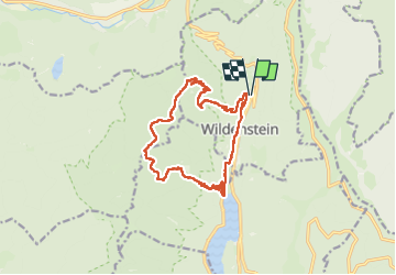
Trail Walking of 15.4 km to be discovered at Grand Est, Haut-Rhin, Wildenstein. This trail is proposed by Godasses et Grosses Pattes.

Description

départ et arrivée du parking et de la cascade du Heidenbad,
on passe par la cascade Heidenbad, Wildenstein et sont église Saint Pierre et Paul, le lac de Kruth, la cascade du Bockloch, le refuge du Hinterbockloch, col de pourri faing,
la chapelle notre dame de la joie,

terrain très accidenté et rocailleux
très humide car beaucoup de sources et ruisseaux,
et le plus dur pour la fin
très très grosse descente interminable.

Elevation profile

Photos

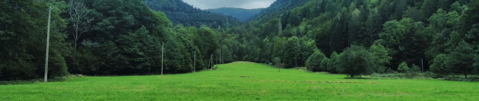
45 photos in total. Please click on a photo to see them all in the gallery.

Positioning

Country:
France
Region :
Grand Est
Department/Province :
Haut-Rhin
Municipality :
Wildenstein
Location:
Unknown
Start:(UTM)
348148 ; 5316649 (32T) N.

Comments

Please log in to post a review or rate the element


Superbe randonnée !


Trails nearby

Trail Walking La Bresse - 2023-04-16 Marche Abri Lac de Blanchemer vers Lac de Lispach - Photo
Walking
GUIDE
holtzv

Walking

Very difficult
(1)
La Bresse, Grand Est, Vosges, France
23 km | 36 km-effort
8h 4min
No
Trail Walking La Bresse - 2023-04-15 Marche Abri Collet de Etang vers Abri Lac de Blanchemer - Photo
Walking
GUIDE
holtzv

Walking

Medium
(1)
La Bresse, Grand Est, Vosges, France
22 km | 35 km-effort
7h 51min
No
Trail Walking Wildenstein - 2022-02-20 Marche Kruth Grand Ventron - Photo
Walking
GUIDE
holtzv

Walking

Very difficult
(1)
Wildenstein, Grand Est, Haut-Rhin, France
16.8 km | 27 km-effort
4h 52min
Yes
Trail Walking La Bresse - Autour du Lac des Corbeaux - Photo
Walking
Alfredy

Walking

Medium
(1)
La Bresse, Grand Est, Vosges, France
3.1 km | 6 km-effort
1h 30min
Yes
Trail Walking La Bresse - Kastelberg des pierres, des lacs, des panoramas magnifiques  - Photo
Walking
Alfredy

Walking

Difficult
(1)
La Bresse, Grand Est, Vosges, France
15.1 km | 26 km-effort
6h 11min
Yes
Trail Walking Wildenstein - Col du Bramont - Machey - Blanchemer - Photo
Walking
VacheKiri67

Walking

Medium
(1)
Wildenstein, Grand Est, Haut-Rhin, France
15.3 km | 22 km-effort
4h 27min
Yes
Trail Mountain bike La Bresse - randonnée découverte à la Bresse.  - Photo
Mountain bike
Dutyrider

Mountain bike

Easy
(1)
La Bresse, Grand Est, Vosges, France
30 km | 41 km-effort
2h 58min
Yes
Trail Walking La Bresse - Rainkopf - Mittlach - Hohneck - Photo
Walking
tracegps

Walking

Difficult
(1)
La Bresse, Grand Est, Vosges, France
22 km | 41 km-effort
8h 0min
Yes
Trail Walking La Bresse - Le Lac des Corbeaux - La Bresse - Photo
Walking
tracegps

Walking

Medium
(2)
La Bresse, Grand Est, Vosges, France
3 km | 6 km-effort
2h 0min
Yes


Close
My subscriptions