Trail Walking Entraunes - Cirque de la Sanguinière, 05-09-2024 - Photo

Cirque de la Sanguinière, 05-09-2024

© OpenStreetMap contributors
Length
Length
12.2 km
Max alt
Max alt
2494 m
Uphill gradient
Uphill gradient
617 m
Km-Effort
Km-Effort  
20 km
Min alt
Min alt
1878 m
Downhill gradient
Downhill gradient
615 m
Boucle
Boucle
Yes
Creation date :
2024-09-05 07:01:51.907
Updated on :
2024-09-16 17:33:05.946

(0 Reviews)

Walking
Walking
3h53
Difficulty : Medium

Scan this QR Code to open this trail in the SityTrail application

FREE GPS app for hiking

Logo SityTrail SityTrail

IGN / Geographical institutes

Download SityTrail from the App Store Download SityTrail from Google Play

Logo SityTrail SityTrail World

The world is yours!

Download SityTrail from the App Store Download SityTrail from Google Play Download SityTrail on Huawei AppGallery

About

Trail Walking of 12.2 km to be discovered at Provence-Alpes-Côte d'Azur, Maritime Alps, Entraunes. This trail is proposed by Christiancordin.

Description

D PK situé sur la gauche de la D 2202 après le refuge de la Cantonnière, ruisseau de Sanguinière, cabanes de Sanguinière, vue sur pointe Côte de l'Ane, roche trouée, arête Kerbrat-Metge, col de la roche Trouée, ruisseau de Gorgias.

Elevation profile

Photos

Positioning

Country:
France
Region :
Provence-Alpes-Côte d'Azur
Department/Province :
Maritime Alps
Municipality :
Entraunes
Location:
Unknown
Start:(UTM)
320961 ; 4901526 (32T) N.

Trails nearby

Trail Walking Uvernet-Fours - Mercantour Le Cimet 3020 m - Photo
Walking
pascalspr

Walking

Medium
(2)
Uvernet-Fours, Provence-Alpes-Côte d'Azur, Alpes-de-Haute-Provence, France
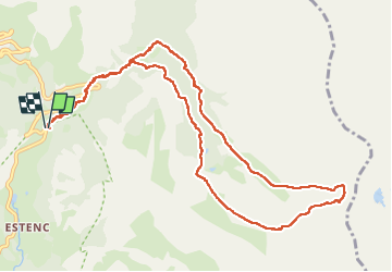
20 km | 34 km-effort
5h 49min
Yes
Trail Walking Uvernet-Fours - Mont Pelat par la grande barre - Photo
Walking
Gouze13

Walking

Difficult
(1)
Uvernet-Fours, Provence-Alpes-Côte d'Azur, Alpes-de-Haute-Provence, France
16.4 km | 34 km-effort
4h 0min
Yes
Trail Walking Uvernet-Fours - Cimet - Photo
Walking
GUIDE
Marco05

Walking

Difficult
Uvernet-Fours, Provence-Alpes-Côte d'Azur, Alpes-de-Haute-Provence, France
13.6 km | 27 km-effort
6h 10min
Yes
Trail On foot Entraunes - Circuit des Lacs - Photo
On foot
GUIDE+

On foot

Easy
Entraunes, Provence-Alpes-Côte d'Azur, Maritime Alps, France
8.9 km | 14.7 km-effort
3h 21min
Yes
Trail On foot Entraunes - Col de la Boucharde - Photo
On foot
GUIDE+

On foot

Medium
Entraunes, Provence-Alpes-Côte d'Azur, Maritime Alps, France
16.6 km | 29 km-effort
6h 33min
Yes
Trail On foot Entraunes - Tête de la Boulière - Photo
On foot
GUIDE+

On foot

Medium
Entraunes, Provence-Alpes-Côte d'Azur, Maritime Alps, France
16.9 km | 29 km-effort
6h 41min
Yes
Trail Walking Allos - le mont Pelat et le lac du trou de l'aigle - Photo
Walking
GUIDE
amiral13

Walking

Medium
Allos, Provence-Alpes-Côte d'Azur, Alpes-de-Haute-Provence, France
14.4 km | 27 km-effort
7h 19min
Yes
Trail Walking Uvernet-Fours - Le Cimet - Photo
Walking
bozo1970

Walking

Difficult
Uvernet-Fours, Provence-Alpes-Côte d'Azur, Alpes-de-Haute-Provence, France
13.9 km | 27 km-effort
4h 26min
Yes
Trail Walking Allos - Pk du Laus - Lacs de la Petite Cayolle, des Garrets et Allos - Photo
Walking
LtZIP

Walking

Medium
Allos, Provence-Alpes-Côte d'Azur, Alpes-de-Haute-Provence, France
13.9 km | 22 km-effort
4h 7min
Yes


Close
My subscriptions