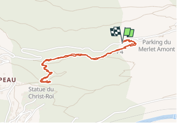
Trail Walking Les Houches - J14 - R13 - La statue du Christ Roi - Photo

J14 - R13 - La statue du Christ Roi

© OpenStreetMap contributors
Length
Length
2.3 km
Max alt
Max alt
1374 m
Uphill gradient
Uphill gradient
216 m
Km-Effort
Km-Effort  
5.2 km
Min alt
Min alt
1192 m
Downhill gradient
Downhill gradient
219 m
Boucle
Boucle
Yes
Creation date :
2024-09-14 13:25:54.896
Updated on :
2024-09-14 15:04:10.158

(0 Reviews)

Walking
Walking
56m
Difficulty : Medium

Scan this QR Code to open this trail in the SityTrail application

FREE GPS app for hiking

Logo SityTrail SityTrail

IGN / Geographical institutes

Download SityTrail from the App Store Download SityTrail from Google Play

Logo SityTrail SityTrail World

The world is yours!

Download SityTrail from the App Store Download SityTrail from Google Play Download SityTrail on Huawei AppGallery

About

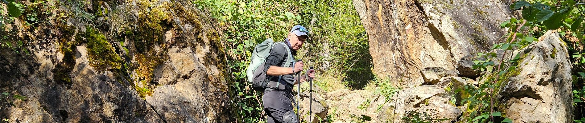
Trail Walking of 2.3 km to be discovered at Auvergne-Rhône-Alpes, Upper Savoy, Les Houches. This trail is proposed by mumu.larandonneuse.

Description

J14 - R13 - La statue du Christ Roi

Le village des Houches est surplombé par une impressionnante statue qui n’est pas sans rappeler le Christ du Corcovado à Rio de Janeiro.
Ce Christ-Roi de 25 mètres de haut, culmine à 1200 mètres d’altitude et veille sur la Vallée de Chamonix-Mont-Blanc. Il a été construit en 1933 sur l’impulsion de l’abbé Claude Marie Delassiat, curé des Houches, pour symboliser l’Amour et la Paix entre les hommes. 
Récemment inscrite au titre des monuments historiques, cette statue est l’une des plus hautes de France.
📍🅿️ 4 du Merlet

Elevation profile

Photos

Positioning

Country:
France
Region :
Auvergne-Rhône-Alpes
Department/Province :
Upper Savoy
Municipality :
Les Houches
Location:
Unknown
Start:(UTM)
330040 ; 5085839 (32T) N.

Trails nearby

Trail Walking Les Houches - 2024-05-29_17h11m02_christ-roi - Photo
Walking
GUIDE
mumu.larandonneuse

Walking

Easy
(1)
Les Houches, Auvergne-Rhône-Alpes, Upper Savoy, France
1.8 km | 4.2 km-effort
56min
No
Trail Running Chamonix-Mont-Blanc - The North Face© Ultra Trail du Mont-Blanc© UTMB 2008 - Photo
Running
tracegps

Running

Very difficult
(2)
Chamonix-Mont-Blanc, Auvergne-Rhône-Alpes, Upper Savoy, France
160 km | 288 km-effort
46h 0min
Yes
Trail Walking Chamonix-Mont-Blanc - Glacier des Bossons Les Houches Chamonix - Photo
Walking
tracegps

Walking

Difficult
(2)
Chamonix-Mont-Blanc, Auvergne-Rhône-Alpes, Upper Savoy, France
13.1 km | 28 km-effort
5h 0min
Yes
Trail Walking Chamonix-Mont-Blanc - Chalet des Pyramides 1895m 11.7.22 - Photo
Walking
GUIDE
fredetpascale

Walking

Medium
Chamonix-Mont-Blanc, Auvergne-Rhône-Alpes, Upper Savoy, France
7.7 km | 15.2 km-effort
3h 30min
Yes
Trail Walking Chamonix-Mont-Blanc - La cascade du dard - Photo
Walking
GUIDE
pascalou73

Walking

Medium
Chamonix-Mont-Blanc, Auvergne-Rhône-Alpes, Upper Savoy, France
8.2 km | 13.6 km-effort
2h 0min
Yes
Trail Walking Chamonix-Mont-Blanc - Le lac bleus - Photo
Walking
GUIDE
pascalou73

Walking

Medium
Chamonix-Mont-Blanc, Auvergne-Rhône-Alpes, Upper Savoy, France
17.1 km | 35 km-effort
6h 57min
Yes
Trail Walking Les Houches - Chalets de Charlousse - Photo
Walking
YannPro81

Walking

Easy
(2)
Les Houches, Auvergne-Rhône-Alpes, Upper Savoy, France
9.2 km | 14.1 km-effort
2h 28min
Yes
Trail Walking Chamonix-Mont-Blanc - Chamonix, cascade du dard,  glacier des boissons - Photo
Walking
FLORENSAC

Walking

Difficult
Chamonix-Mont-Blanc, Auvergne-Rhône-Alpes, Upper Savoy, France
9.4 km | 17.2 km-effort
4h 24min
Yes
Trail Walking Chamonix-Mont-Blanc - 2024-05-29_17h56m49_Cirkwi-Randonne_de_l_Alpage_de_Blaitire - Photo
Walking
GUIDE
mumu.larandonneuse

Walking

Difficult
Chamonix-Mont-Blanc, Auvergne-Rhône-Alpes, Upper Savoy, France
5.9 km | 14.7 km-effort
3h 20min
Yes


Close
My subscriptions