![](/images/other/stat-length.png)
![Trail Walking Le Haut-Bréda - Traversée du Massif de Belledonne GR 738 partie 2 - Photo](https://media.geolcdn.com/t/1900/400/ext.pjpeg?maxdim=2&url=https%3A%2F%2Fstatic1.geolcdn.com%2Fsiteimages%2Fupload%2Ffiles%2F1553511878bg_sport_marche.png)
Traversée du Massif de Belledonne GR 738 partie 2
grattounette
User
![Length](/images/other/stat-length.png)
![Max alt](https://static1.geolcdn.com/siteimages/upload/files/1508320355ic_sort_altitude_max_24dp.png)
![Uphill gradient](https://static1.geolcdn.com/siteimages/upload/files/1508320355ic_sort_den_pos_24dp.png)
![Km-Effort](/images/other/stat-length.png)
![Min alt](https://static1.geolcdn.com/siteimages/upload/files/1508320355ic_sort_altitude_min_24dp.png)
![Downhill gradient](https://static1.geolcdn.com/siteimages/upload/files/1508320355ic_sort_den_neg_24dp.png)
![Boucle](https://static1.geolcdn.com/siteimages/upload/files/16400158638029165_repeat_loop_refresh_sync_direction_icon.png)
![Walking](https://static1.geolcdn.com/sitytour/trail-icons/101.png)
73h48
Difficulty : Very difficult
![Scan this QR Code to open this trail in the SityTrail application](https://capi.geolives.com/qq0zvz2zws4bq2lad0pu/sitytour/trails/4189487/qr.png?size=200)
FREE GPS app for hiking
About
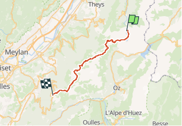
Trail Walking of 37 km to be discovered at Auvergne-Rhône-Alpes, Isère, Le Haut-Bréda. This trail is proposed by grattounette.
Description
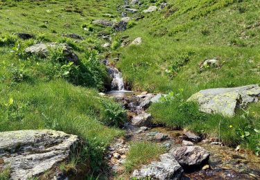
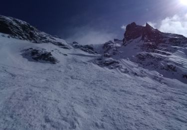
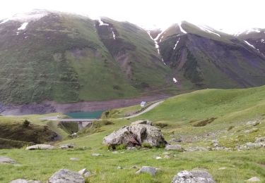
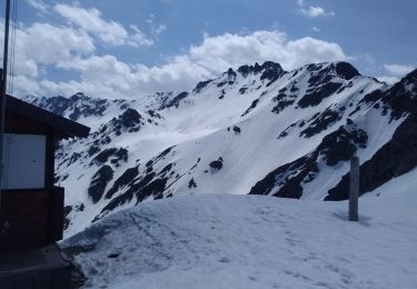
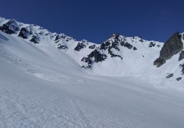
2eme partie pour finir notre traversée du Massif de Belledonne, nous laissons notre voiture a Chamrousse le Recoin pour prendre un taxi qui nous dépose après le petit village du Rivier d'allemont sur la D526 environ 1km500 a la sortie du village pour déposer a gauche sur le chemin blanc en direction du Parking Point de côté 1261 ou notre périple commence GRP tour des lacs des sept Laux . je n'ai pas mis la trace enregistré.pour infos très belle montée bien raide jusqu'au premier lac de la Sagne puis le lac de la corne, lac leplan et rejoindre le GR738 au niveau de la bergerie du Cos et son lac du même nom et finir notre monté par lac Cottepens et le refuge des sept Laux, D 996 ,D-120 . le lendemain on revient sur nos traces jusqu'à la bergerie du Cos pour commencer notre ascension vers le Col de la vache a 2556M gros pierrier pendant cette montée et après pour la descente, crête du cheval, nouvelle monté au Col de l'aigleton, descendre et finir cette journée technique au refuge du Habert d'Aiguebelle. pour cette nouvelle journée remonter au col du pas de la Coche, superbe vue depuis les crêtes en direction de la Brèche de la roche fendue, montée très technique dans un pierrier 2400m , descente pour rejoindre le col de la mine de fer, habert de la pierre et finir cette journée au refuge Jean Collet. on repart pour une nouvelle journée en descendant vers la passerelle qui franchit le torrent de Vorz , et sa remonte en direction du col de la sitre, très beau passage en ligne de crête pour rejoindre le Col du Loup, on passe au petit lac du même nom, superbe plateau pour finir par rejoindre le magnifique lac du Crozet, remonter par le vallon du Mercier et arrivé au Col de la Pra et finir juste derrière au refuge de la Pra. dernière journée pour rejoindre Chamrousse Le Recoin, passage par ce beau plateau pour passer par le lac Claret ,le lac Longet et Bernard, passage par la combe de la jasse Balard, lac Léman , on en prend plein les yeux... , direction les lacs Robert , Brèche Robert Nord, petit lac des pourettes pour finir notre périple a Chamrousse. 2eme partie pour clôturer notre traversée du Massif de Belledonne très différente de la 1er partie , très minérale et alpine, très beau treck .je reviendrai pour faire les autres sentiers que nous avons croisé tous au long du GR 👍
Positioning
Comments
Trails nearby
![Trail Walking Saint-Colomban-des-Villards - Lac de l'âne départ pont du Rieu-claret - Photo](https://media.geolcdn.com/t/375/260/da43fabe-f484-4e32-b936-8fd9ca7d3840.jpg&format=jpg&maxdim=2)
![Walking Walking](https://static1.geolcdn.com/sitytour/trail-icons/101.png)
Walking
![](/images/other/stat-length.png)
![](https://static1.geolcdn.com/siteimages/upload/files/16400158638029165_repeat_loop_refresh_sync_direction_icon.png)
![Trail Walking Le Haut-Bréda - Combe du Prat - Photo](https://media.geolcdn.com/t/375/260/6714bc1b-1337-4dda-8a6e-4ad571484b33.jpg&format=jpg&maxdim=2)
![Walking Walking](https://static1.geolcdn.com/sitytour/trail-icons/101.png)
Walking
![](/images/other/stat-length.png)
![](https://static1.geolcdn.com/siteimages/upload/files/16400158638029165_repeat_loop_refresh_sync_direction_icon.png)
![Trail Touring skiing Le Haut-Bréda - Belle Etoile et Pic des Cabottes couloir S - Photo](https://media.geolcdn.com/t/375/260/3f446dca-8587-476b-b4f9-492466f114e8.jpg&format=jpg&maxdim=2)
![Touring skiing Touring skiing](https://static1.geolcdn.com/sitytour/trail-icons/503.png)
Touring skiing
![](/images/other/stat-length.png)
![](https://static1.geolcdn.com/siteimages/upload/files/16400158638029165_repeat_loop_refresh_sync_direction_icon.png)
![Trail Walking Le Haut-Bréda - Les lacs sept Claux - Photo](https://media.geolcdn.com/t/375/260/ab2c771e-7afd-4d71-bf80-bad543cd1a27.jpg&format=jpg&maxdim=2)
![Walking Walking](https://static1.geolcdn.com/sitytour/trail-icons/101.png)
Walking
![](/images/other/stat-length.png)
![](https://static1.geolcdn.com/siteimages/upload/files/16400158638029165_repeat_loop_refresh_sync_direction_icon.png)
![Trail Walking Le Haut-Bréda - cascade du Pissou - Photo](https://media.geolcdn.com/t/375/260/7fdcfb11-ea55-4bb4-a796-d901baffbbd4.jpg&format=jpg&maxdim=2)
![Walking Walking](https://static1.geolcdn.com/sitytour/trail-icons/101.png)
Walking
![](/images/other/stat-length.png)
![](https://static1.geolcdn.com/siteimages/upload/files/16400158638029165_repeat_loop_refresh_sync_direction_icon.png)
![Trail Touring skiing Saint-Colomban-des-Villards - sous la Pyramide, le Pic de l'agnelin, breche du lieutenant - Photo](https://media.geolcdn.com/t/375/260/3492c22d-3806-4810-b41c-bc1908e9403c.jpg&format=jpg&maxdim=2)
![Touring skiing Touring skiing](https://static1.geolcdn.com/sitytour/trail-icons/503.png)
Touring skiing
![](/images/other/stat-length.png)
![](https://static1.geolcdn.com/siteimages/upload/files/16400158638029165_repeat_loop_refresh_sync_direction_icon.png)
![Trail Touring skiing Le Haut-Bréda - cime de la Jase, col de la pouta, col de l'évêque - Photo](https://media.geolcdn.com/t/375/260/398c2455-32f4-45bc-ac0e-2e98301f4be7.jpg&format=jpg&maxdim=2)
![Touring skiing Touring skiing](https://static1.geolcdn.com/sitytour/trail-icons/503.png)
Touring skiing
![](/images/other/stat-length.png)
![](https://static1.geolcdn.com/siteimages/upload/files/16400158638029165_repeat_loop_refresh_sync_direction_icon.png)
![Trail Touring skiing Le Haut-Bréda - pic de la belle étoile, vers la dent du Pra - Photo](https://media.geolcdn.com/t/375/260/841cac3c-ebf0-465f-be3e-6db62d7479f7.jpg&format=jpg&maxdim=2)
![Touring skiing Touring skiing](https://static1.geolcdn.com/sitytour/trail-icons/503.png)
Touring skiing
![](/images/other/stat-length.png)
![](https://static1.geolcdn.com/siteimages/upload/files/16400158638029165_repeat_loop_refresh_sync_direction_icon.png)
![Trail Other activity Le Haut-Bréda - Rocher Blanc 7 Laux - Photo](https://media.geolcdn.com/t/375/260/ext.jpg?maxdim=2&url=https%3A%2F%2Fstatic1.geolcdn.com%2Fsiteimages%2Fupload%2Ffiles%2F1545311037marcheuse_200dpi.jpg)
![Other activity Other activity](https://static1.geolcdn.com/sitytour/trail-icons/900.png)
Other activity
![](/images/other/stat-length.png)
![](https://static1.geolcdn.com/siteimages/upload/files/16400158638029165_repeat_loop_refresh_sync_direction_icon.png)