![](/images/other/stat-length.png)
![Trail Walking Calvi - Calvi, pantalon de la Revelata - Photo](https://media.geolcdn.com/t/1900/400/ext.pjpeg?maxdim=2&url=https%3A%2F%2Fstatic1.geolcdn.com%2Fsiteimages%2Fupload%2Ffiles%2F1553511878bg_sport_marche.png)
Calvi, pantalon de la Revelata
Santblasi
User
![Length](/images/other/stat-length.png)
Length
9.5 km
![Max alt](https://static1.geolcdn.com/siteimages/upload/files/1508320355ic_sort_altitude_max_24dp.png)
Max alt
163 m
![Uphill gradient](https://static1.geolcdn.com/siteimages/upload/files/1508320355ic_sort_den_pos_24dp.png)
Uphill gradient
289 m
![Km-Effort](/images/other/stat-length.png)
Km-Effort
13.4 km
![Min alt](https://static1.geolcdn.com/siteimages/upload/files/1508320355ic_sort_altitude_min_24dp.png)
Min alt
0 m
![Downhill gradient](https://static1.geolcdn.com/siteimages/upload/files/1508320355ic_sort_den_neg_24dp.png)
Downhill gradient
285 m
![Boucle](https://static1.geolcdn.com/siteimages/upload/files/16400158638029165_repeat_loop_refresh_sync_direction_icon.png)
Boucle
Yes
Creation date :
2024-09-14 07:16:25.606
Updated on :
2024-09-14 13:05:18.05
![Walking](https://static1.geolcdn.com/sitytour/trail-icons/101.png)
3h48
Difficulty : Medium
![Scan this QR Code to open this trail in the SityTrail application](https://capi.geolives.com/qq0zvz2zws4bq2lad0pu/sitytour/trails/4189482/qr.png?size=200)
FREE GPS app for hiking
About
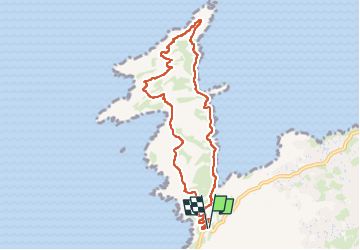
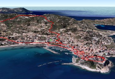
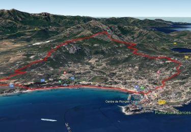
Trail Walking of 9.5 km to be discovered at Corsica, Haute-Corse, Calvi. This trail is proposed by Santblasi.
Description
parking bord de route.
suivre piste carrossable de gauche, puis la quitter pour suivre le sentier bord de falaise et grimper sue les crêtes "Capu Belloni". De très beaux points de vue et continuer jusqu'au phare sans marquage.
Retour par le sentier côtier.
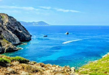
très belle randonnée.
Positioning
Country:
France
Region :
Corsica
Department/Province :
Haute-Corse
Municipality :
Calvi
Location:
Unknown
Start:(Dec)
Start:(UTM)
477499 ; 4711574 (32T) N.
Comments
Trails nearby
![Trail Walking Calvi - Sentier des douaniers de la Revellata - Photo](https://media.geolcdn.com/t/375/260/ext.jpg?maxdim=2&url=https%3A%2F%2Fstatic1.geolcdn.com%2Fsiteimages%2Fupload%2Ffiles%2F1553511878bg_sport_marche.png)
![Walking Walking](https://static1.geolcdn.com/sitytour/trail-icons/101.png)
Sentier des douaniers de la Revellata
Walking
Easy
(7)
Calvi,
Corsica,
Haute-Corse,
France
![](/images/other/stat-length.png)
12 km | 15.3 km-effort
3h 16min
![](https://static1.geolcdn.com/siteimages/upload/files/16400158638029165_repeat_loop_refresh_sync_direction_icon.png)
No
![Trail Walking Calvi - capu di à veta - Photo](https://media.geolcdn.com/t/375/260/ext.jpg?maxdim=2&url=https%3A%2F%2Fservices.sitytrail.com%2FGeolivesWS%2FDownloadMedia.ashx%3FTrailID%3D151658%26Media%3D20120904145923.jpeg)
![Walking Walking](https://static1.geolcdn.com/sitytour/trail-icons/101.png)
capu di à veta
Walking
Difficult
(2)
Calvi,
Corsica,
Haute-Corse,
France
![](/images/other/stat-length.png)
4.2 km | 9 km-effort
2h 6min
![](https://static1.geolcdn.com/siteimages/upload/files/16400158638029165_repeat_loop_refresh_sync_direction_icon.png)
No
![Trail Walking Calvi - Boucle Croix des Balkans - Phare de Revellata - Notre dame de la Sierra - Photo](https://media.geolcdn.com/t/375/260/6cda2d7e-404d-456c-b881-88a3bd721ab4.jpg&format=jpg&maxdim=2)
![Walking Walking](https://static1.geolcdn.com/sitytour/trail-icons/101.png)
Boucle Croix des Balkans - Phare de Revellata - Notre dame de la Sierra
Walking
Difficult
Calvi,
Corsica,
Haute-Corse,
France
![](/images/other/stat-length.png)
17.5 km | 24 km-effort
5h 0min
![](https://static1.geolcdn.com/siteimages/upload/files/16400158638029165_repeat_loop_refresh_sync_direction_icon.png)
Yes
![Trail Walking Calvi - Calvi Citadelle et plages - Photo](https://media.geolcdn.com/t/375/260/892043f0-8f9b-48ae-87be-36b2ee765259.jpg&format=jpg&maxdim=2)
![Walking Walking](https://static1.geolcdn.com/sitytour/trail-icons/101.png)
Calvi Citadelle et plages
Walking
Very easy
Calvi,
Corsica,
Haute-Corse,
France
![](/images/other/stat-length.png)
11.7 km | 13.9 km-effort
3h 14min
![](https://static1.geolcdn.com/siteimages/upload/files/16400158638029165_repeat_loop_refresh_sync_direction_icon.png)
Yes
![Trail Walking Calvi - Citadelle Calvi - Village - Notre dame de la Serra - Photo](https://media.geolcdn.com/t/375/260/3f66e714-4600-4062-9831-1d9f3d4886b1.jpg&format=jpg&maxdim=2)
![Walking Walking](https://static1.geolcdn.com/sitytour/trail-icons/101.png)
Citadelle Calvi - Village - Notre dame de la Serra
Walking
Easy
Calvi,
Corsica,
Haute-Corse,
France
![](/images/other/stat-length.png)
10.3 km | 14.5 km-effort
6h 0min
![](https://static1.geolcdn.com/siteimages/upload/files/16400158638029165_repeat_loop_refresh_sync_direction_icon.png)
Yes
![Trail Walking Calvi - Calvi - Capu di a Veta - Croix des autrichiens - Photo](https://media.geolcdn.com/t/375/260/17f2f489-34ae-4038-8251-38c4882809b9.jpg&format=jpg&maxdim=2)
![Walking Walking](https://static1.geolcdn.com/sitytour/trail-icons/101.png)
Calvi - Capu di a Veta - Croix des autrichiens
Walking
Difficult
(1)
Calvi,
Corsica,
Haute-Corse,
France
![](/images/other/stat-length.png)
15.6 km | 26 km-effort
5h 30min
![](https://static1.geolcdn.com/siteimages/upload/files/16400158638029165_repeat_loop_refresh_sync_direction_icon.png)
Yes
![Trail Walking Calvi - Calvi pointe revalatta - Photo](https://media.geolcdn.com/t/375/260/73cb0d70-35b6-40e4-8aac-0e3d36881dd5.jpg&format=jpg&maxdim=2)
![Walking Walking](https://static1.geolcdn.com/sitytour/trail-icons/101.png)
Calvi pointe revalatta
Walking
Easy
Calvi,
Corsica,
Haute-Corse,
France
![](/images/other/stat-length.png)
14.7 km | 19.3 km-effort
4h 43min
![](https://static1.geolcdn.com/siteimages/upload/files/16400158638029165_repeat_loop_refresh_sync_direction_icon.png)
Yes
![Trail Walking Calvi - Pointe de la bêta - Photo](https://media.geolcdn.com/t/375/260/bf75e6b6-3d62-4a80-ad8d-c13125feb696.jpg&format=jpg&maxdim=2)
![Walking Walking](https://static1.geolcdn.com/sitytour/trail-icons/101.png)
Pointe de la bêta
Walking
Very difficult
Calvi,
Corsica,
Haute-Corse,
France
![](/images/other/stat-length.png)
14.6 km | 25 km-effort
4h 50min
![](https://static1.geolcdn.com/siteimages/upload/files/16400158638029165_repeat_loop_refresh_sync_direction_icon.png)
Yes
![Trail Walking Calvi - 2012-05-29 14h48m26 - Photo](https://media.geolcdn.com/t/375/260/ext.jpg?maxdim=2&url=https%3A%2F%2Fstatic1.geolcdn.com%2Fsiteimages%2Fupload%2Ffiles%2F1553511878bg_sport_marche.png)
![Walking Walking](https://static1.geolcdn.com/sitytour/trail-icons/101.png)
2012-05-29 14h48m26
Walking
Medium
(1)
Calvi,
Corsica,
Haute-Corse,
France
![](/images/other/stat-length.png)
6.7 km | 9.1 km-effort
1h 54min
![](https://static1.geolcdn.com/siteimages/upload/files/16400158638029165_repeat_loop_refresh_sync_direction_icon.png)
No