Trail Walking Gueberschwihr - Gueberschwihr - Voegtlinshoffen - N.-D. de Schauenberg - Pfaffenheim - Photo

Gueberschwihr - Voegtlinshoffen - N.-D. de Schauenberg - Pfaffenheim

 Bart2015
Bart2015

User

© OpenStreetMap contributors
Length
Length
13.1 km
Max alt
Max alt
493 m
Uphill gradient
Uphill gradient
435 m
Km-Effort
Km-Effort  
18.9 km
Min alt
Min alt
227 m
Downhill gradient
Downhill gradient
438 m
Boucle
Boucle
Yes
Creation date :
2024-09-14 08:05:14.304
Updated on :
2024-09-14 15:07:49.246

(0 Reviews)

Walking
Walking
4h17
Difficulty : Difficult

Scan this QR Code to open this trail in the SityTrail application

FREE GPS app for hiking

Logo SityTrail SityTrail

IGN / Geographical institutes

Download SityTrail from the App Store Download SityTrail from Google Play

Logo SityTrail SityTrail World

The world is yours!

Download SityTrail from the App Store Download SityTrail from Google Play Download SityTrail on Huawei AppGallery

About

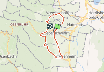
Trail Walking of 13.1 km to be discovered at Grand Est, Haut-Rhin, Gueberschwihr. This trail is proposed by Bart2015.

Description

Belle balade dans le vignoble au départ du joli village de Gueberschwihr. Elle reprend une partie du sentier mystique qui parcourt  le patrimoine spirituel et religieux de l’époque mérovingienne et médiévale : rocher du coucou, table des druides, N.-D. de Schauenberg et son chemin de croix. Passage près de plusieurs sites d'escalade.
Bonne rando, à prioriser en période de vendanges ou à l'automne. Soyez prudents ...

Elevation profile

Photos

29 photos in total. Please click on a photo to see them all in the gallery.

Positioning

Country:
France
Region :
Grand Est
Department/Province :
Haut-Rhin
Municipality :
Gueberschwihr
Location:
Unknown
Start:(UTM)
371352 ; 5318216 (32U) N.

Trails nearby

Trail Walking Westhalten - 2021 03 04 Westhalten - Photo
Walking
E.BURCK

Walking

Easy
(1)
Westhalten, Grand Est, Haut-Rhin, France
7.7 km | 11.3 km-effort
2h 21min
Yes
Trail Walking Osenbach - Osenbach - Sentier des Sols - Photo
Walking
gscheven

Walking

Easy
(1)
Osenbach, Grand Est, Haut-Rhin, France
4.7 km | 6.6 km-effort
3h 0min
Yes
Trail Walking Eguisheim - suuntoapp-Hiking-2023-12-29T09-05-16Z - Photo
Walking
GUIDE
holtzv

Walking

Medium
Eguisheim, Grand Est, Haut-Rhin, France
22 km | 32 km-effort
7h 16min
Yes
Trail Walking Rouffach - SityTrail - Rouffach vers Schauenberg variante - Photo
Walking
E.BURCK

Walking

Easy
(1)
Rouffach, Grand Est, Haut-Rhin, France
10.6 km | 15.3 km-effort
3h 29min
Yes
Trail Walking Westhalten - ND du Hubel_Schauenberg - Photo
Walking
dick68

Walking

Medium
(2)
Westhalten, Grand Est, Haut-Rhin, France
8.3 km | 11.7 km-effort
2h 39min
Yes
Trail Walking Pfaffenheim - Schauenberg 1 - Photo
Walking
regisbodilis

Walking

Easy
(1)
Pfaffenheim, Grand Est, Haut-Rhin, France
10.3 km | 16.5 km-effort
3h 30min
Yes
Trail Walking Westhalten - Westhalten - Rouffach  - Photo
Walking
Richard68500

Walking

Difficult
Westhalten, Grand Est, Haut-Rhin, France
8.9 km | 13 km-effort
3h 22min
Yes
Trail Walking Husseren-les-Châteaux - Husseren les Châteaux - Photo
Walking
oscar1

Walking

Easy
Husseren-les-Châteaux, Grand Est, Haut-Rhin, France
12.7 km | 19.1 km-effort
3h 24min
Yes
Trail Walking Soultzmatt - Rando du 30/03/2034 - Photo
Walking
boubou68

Walking

Difficult
Soultzmatt, Grand Est, Haut-Rhin, France
19.5 km | 29 km-effort
4h 32min
Yes


Close
My subscriptions