![](/images/other/stat-length.png)
![Trail Walking Vagney - La cascade du Pissoire - Photo](https://media.geolcdn.com/t/1900/400/28c5dee6-c38e-449d-b8db-628f061aeb9b.jpg&format=pjpeg&maxdim=2)
La cascade du Pissoire
FouargePatrick
User
![Length](/images/other/stat-length.png)
Length
2.7 km
![Max alt](https://static1.geolcdn.com/siteimages/upload/files/1508320355ic_sort_altitude_max_24dp.png)
Max alt
803 m
![Uphill gradient](https://static1.geolcdn.com/siteimages/upload/files/1508320355ic_sort_den_pos_24dp.png)
Uphill gradient
64 m
![Km-Effort](/images/other/stat-length.png)
Km-Effort
3.6 km
![Min alt](https://static1.geolcdn.com/siteimages/upload/files/1508320355ic_sort_altitude_min_24dp.png)
Min alt
739 m
![Downhill gradient](https://static1.geolcdn.com/siteimages/upload/files/1508320355ic_sort_den_neg_24dp.png)
Downhill gradient
63 m
![Boucle](https://static1.geolcdn.com/siteimages/upload/files/16400158638029165_repeat_loop_refresh_sync_direction_icon.png)
Boucle
Yes
Creation date :
2024-09-13 10:41:09.0
Updated on :
2024-09-13 20:30:40.778
![Walking](https://static1.geolcdn.com/sitytour/trail-icons/101.png)
54m
Difficulty : Easy
![Scan this QR Code to open this trail in the SityTrail application](https://capi.geolives.com/qq0zvz2zws4bq2lad0pu/sitytour/trails/4188287/qr.png?size=200)
FREE GPS app for hiking
About
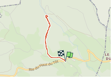
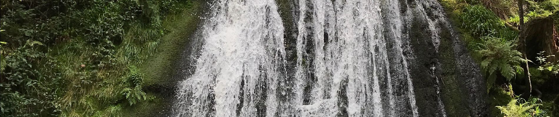
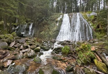
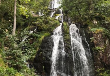
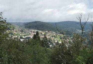
Trail Walking of 2.7 km to be discovered at Grand Est, Vosges, Vagney. This trail is proposed by FouargePatrick.
Description
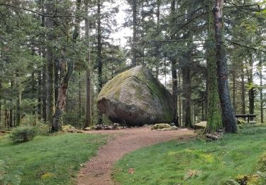
Au départ du parking la croix des Hêtres, prendre la Route Du Haut des Charmes et au premier Y prendre le chemin à droite jusqu'à la cascade du Pissoire.
Cette balade est faisable avec une poussette pour enfant.
Positioning
Country:
France
Region :
Grand Est
Department/Province :
Vosges
Municipality :
Vagney
Location:
Unknown
Start:(Dec)
Start:(UTM)
332361 ; 5323347 (32U) N.
Comments
Trails nearby
![Trail Walking Sapois - La Cascade de la Pissoire - Photo](https://media.geolcdn.com/t/375/260/ext.jpg?maxdim=2&url=https%3A%2F%2Fservices.sitytrail.com%2FGeolivesWS%2FDownloadMedia.ashx%3FTrailID%3D110286%26Media%3D5680_3.jpg)
![Walking Walking](https://static1.geolcdn.com/sitytour/trail-icons/101.png)
La Cascade de la Pissoire
Walking
Medium
(2)
Sapois,
Grand Est,
Vosges,
France
![](/images/other/stat-length.png)
6.3 km | 8.9 km-effort
2h 0min
![](https://static1.geolcdn.com/siteimages/upload/files/16400158638029165_repeat_loop_refresh_sync_direction_icon.png)
Yes
![Trail Walking Le Syndicat - Balcon du Solem - Photo](https://media.geolcdn.com/t/375/260/ext.jpg?maxdim=2&url=https%3A%2F%2Fservices.sitytrail.com%2FGeolivesWS%2FDownloadMedia.ashx%3FTrailID%3D109882%26Media%3D4887_1.jpg)
![Walking Walking](https://static1.geolcdn.com/sitytour/trail-icons/101.png)
Balcon du Solem
Walking
Medium
(1)
Le Syndicat,
Grand Est,
Vosges,
France
![](/images/other/stat-length.png)
4.3 km | 7.4 km-effort
2h 0min
![](https://static1.geolcdn.com/siteimages/upload/files/16400158638029165_repeat_loop_refresh_sync_direction_icon.png)
Yes
![Trail Walking Sapois - La Cascade de la Pissoire - Photo](https://media.geolcdn.com/t/375/260/ext.jpg?maxdim=2&url=https%3A%2F%2Fstatic1.geolcdn.com%2Fsiteimages%2Fupload%2Ffiles%2F1553511878bg_sport_marche.png)
![Walking Walking](https://static1.geolcdn.com/sitytour/trail-icons/101.png)
La Cascade de la Pissoire
Walking
Easy
(3)
Sapois,
Grand Est,
Vosges,
France
![](/images/other/stat-length.png)
6.3 km | 8.9 km-effort
1h 40min
![](https://static1.geolcdn.com/siteimages/upload/files/16400158638029165_repeat_loop_refresh_sync_direction_icon.png)
Yes
![Trail Walking Le Tholy - Sentier de la Roche Au Blaireau depuis le gîte - Photo](https://media.geolcdn.com/t/375/260/953f411c-aa19-4208-97f3-48d7a7911f9d.jpg&format=jpg&maxdim=2)
![Walking Walking](https://static1.geolcdn.com/sitytour/trail-icons/101.png)
Sentier de la Roche Au Blaireau depuis le gîte
Walking
Medium
Le Tholy,
Grand Est,
Vosges,
France
![](/images/other/stat-length.png)
4.4 km | 6.5 km-effort
1h 25min
![](https://static1.geolcdn.com/siteimages/upload/files/16400158638029165_repeat_loop_refresh_sync_direction_icon.png)
Yes
![Trail Walking Vagney - Cascade de la Pissoire - Haut du Tôt - Photo](https://media.geolcdn.com/t/375/260/503773b0-6016-477e-af7b-2c79a373ecc2.jpg&format=jpg&maxdim=2)
![Walking Walking](https://static1.geolcdn.com/sitytour/trail-icons/101.png)
Cascade de la Pissoire - Haut du Tôt
Walking
Medium
Vagney,
Grand Est,
Vosges,
France
![](/images/other/stat-length.png)
6.4 km | 8.8 km-effort
2h 8min
![](https://static1.geolcdn.com/siteimages/upload/files/16400158638029165_repeat_loop_refresh_sync_direction_icon.png)
Yes
![Trail Walking Le Tholy - La grande cascade du Tendon au départ du Grand Caillou. - Photo](https://media.geolcdn.com/t/375/260/29f756ea-f122-4fe5-a807-1bae772526aa.jpg&format=jpg&maxdim=2)
![Walking Walking](https://static1.geolcdn.com/sitytour/trail-icons/101.png)
La grande cascade du Tendon au départ du Grand Caillou.
Walking
Difficult
Le Tholy,
Grand Est,
Vosges,
France
![](/images/other/stat-length.png)
9 km | 12.2 km-effort
2h 46min
![](https://static1.geolcdn.com/siteimages/upload/files/16400158638029165_repeat_loop_refresh_sync_direction_icon.png)
Yes
![Trail Walking La Forge - La roche des corbeaux, La Forge - Photo](https://media.geolcdn.com/t/375/260/130216fa-767d-4902-bf97-0a8dff8eb2b3.jpg&format=jpg&maxdim=2)
![Walking Walking](https://static1.geolcdn.com/sitytour/trail-icons/101.png)
La roche des corbeaux, La Forge
Walking
Medium
La Forge,
Grand Est,
Vosges,
France
![](/images/other/stat-length.png)
7.8 km | 11.2 km-effort
2h 33min
![](https://static1.geolcdn.com/siteimages/upload/files/16400158638029165_repeat_loop_refresh_sync_direction_icon.png)
Yes
![Trail Walking Le Tholy - Le trou de l'enfer - Photo](https://media.geolcdn.com/t/375/260/b8b0e984-8b12-439a-8fed-764b95b3aaa2.jpg&format=jpg&maxdim=2)
![Walking Walking](https://static1.geolcdn.com/sitytour/trail-icons/101.png)
Le trou de l'enfer
Walking
Medium
Le Tholy,
Grand Est,
Vosges,
France
![](/images/other/stat-length.png)
10.2 km | 14.2 km-effort
2h 48min
![](https://static1.geolcdn.com/siteimages/upload/files/16400158638029165_repeat_loop_refresh_sync_direction_icon.png)
Yes
![Trail Walking Basse-sur-le-Rupt - Col de menufosse-chalet des charmes-pierre 4 communes - Photo](https://media.geolcdn.com/t/375/260/ext.jpg?maxdim=2&url=https%3A%2F%2Fstatic1.geolcdn.com%2Fsiteimages%2Fupload%2Ffiles%2F1553511878bg_sport_marche.png)
![Walking Walking](https://static1.geolcdn.com/sitytour/trail-icons/101.png)
Col de menufosse-chalet des charmes-pierre 4 communes
Walking
Medium
(1)
Basse-sur-le-Rupt,
Grand Est,
Vosges,
France
![](/images/other/stat-length.png)
5 km | 6.6 km-effort
1h 29min
![](https://static1.geolcdn.com/siteimages/upload/files/16400158638029165_repeat_loop_refresh_sync_direction_icon.png)
Yes