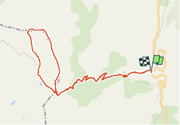
Trail Walking Uvernet-Fours - Le Cimet - Photo
 bozo1970
bozo1970

User

© OpenStreetMap contributors
Length
Length
13.9 km
Max alt
Max alt
3007 m
Uphill gradient
Uphill gradient
1013 m
Km-Effort
Km-Effort  
27 km
Min alt
Min alt
2059 m
Downhill gradient
Downhill gradient
1017 m
Boucle
Boucle
Yes
Creation date :
2024-09-12 07:57:15.0
Updated on :
2024-09-12 18:53:57.297

(0 Reviews)

Walking
Walking
4h26
Difficulty : Difficult

Scan this QR Code to open this trail in the SityTrail application

FREE GPS app for hiking

Logo SityTrail SityTrail

IGN / Geographical institutes

Download SityTrail from the App Store Download SityTrail from Google Play

Logo SityTrail SityTrail World

The world is yours!

Download SityTrail from the App Store Download SityTrail from Google Play Download SityTrail on Huawei AppGallery

About

Trail Walking of 13.9 km to be discovered at Provence-Alpes-Côte d'Azur, Alpes-de-Haute-Provence, Uvernet-Fours. This trail is proposed by bozo1970.

Description

Départ du pont à la côte 2062
Direction le Petit Col de Talon en 1h16’ D 606 et 4km600 puis la crête du Cimet
Sommet en 2h21’ D 942 et 6km600
Descente vers la Croix de Paris-Saïgon, puis le long des ruisseaux jusqu’au GR56
Lac du Cimet vert cl
Petit Col de Talon en 3h19’ D  1027 et 9km330
A/R en 4h25’ D 1027 et 14km
Chamois    

Elevation profile

Photos

Positioning

Country:
France
Region :
Provence-Alpes-Côte d'Azur
Department/Province :
Alpes-de-Haute-Provence
Municipality :
Uvernet-Fours
Location:
Unknown
Start:(UTM)
319759 ; 4905478 (32T) N.

Trails nearby

Trail Walking Uvernet-Fours - Mercantour Le Cimet 3020 m - Photo
Walking
pascalspr

Walking

Medium
(2)
Uvernet-Fours, Provence-Alpes-Côte d'Azur, Alpes-de-Haute-Provence, France
20 km | 34 km-effort
5h 49min
Yes
Trail Walking Uvernet-Fours - Mont Pelat par la grande barre - Photo
Walking
Gouze13

Walking

Difficult
(1)
Uvernet-Fours, Provence-Alpes-Côte d'Azur, Alpes-de-Haute-Provence, France
16.4 km | 34 km-effort
4h 0min
Yes
Trail Walking Uvernet-Fours - Autour de la Pierre Eclatée - Photo
Walking
tracegps

Walking

Very difficult
(1)
Uvernet-Fours, Provence-Alpes-Côte d'Azur, Alpes-de-Haute-Provence, France
13.9 km | 24 km-effort
6h 0min
Yes
Trail Walking Uvernet-Fours - Cimet - Photo
Walking
GUIDE
Marco05

Walking

Difficult
Uvernet-Fours, Provence-Alpes-Côte d'Azur, Alpes-de-Haute-Provence, France
13.6 km | 27 km-effort
6h 10min
Yes
Trail On foot Entraunes - Circuit des Lacs - Photo
On foot
GUIDE+

On foot

Easy
Entraunes, Provence-Alpes-Côte d'Azur, Maritime Alps, France
8.9 km | 14.7 km-effort
3h 21min
Yes
Trail On foot Entraunes - Col de la Boucharde - Photo
On foot
GUIDE+

On foot

Medium
Entraunes, Provence-Alpes-Côte d'Azur, Maritime Alps, France
16.6 km | 29 km-effort
6h 33min
Yes
Trail On foot Uvernet-Fours - Pointe de Colombart - Photo
On foot
GUIDE+

On foot

Easy
Uvernet-Fours, Provence-Alpes-Côte d'Azur, Alpes-de-Haute-Provence, France
8.1 km | 11.7 km-effort
2h 40min
Yes
Trail Walking Allos - le mont Pelat et le lac du trou de l'aigle - Photo
Walking
GUIDE
amiral13

Walking

Medium
Allos, Provence-Alpes-Côte d'Azur, Alpes-de-Haute-Provence, France
14.4 km | 27 km-effort
7h 19min
Yes
Trail Walking Entraunes - Cirque de la Sanguinière, 05-09-2024 - Photo
Walking
Christiancordin

Walking

Medium
Entraunes, Provence-Alpes-Côte d'Azur, Maritime Alps, France
12.2 km | 20 km-effort
3h 53min
Yes


Close
My subscriptions