![](/images/other/stat-length.png)
![Trail Walking Mauges-sur-Loire - Entre Èvre et Loire - Photo](https://media.geolcdn.com/t/1900/400/ext.pjpeg?maxdim=2&url=https%3A%2F%2Fstatic1.geolcdn.com%2Fsiteimages%2Fupload%2Ffiles%2F1553511878bg_sport_marche.png)
Entre Èvre et Loire
neoroll44
User
![Length](/images/other/stat-length.png)
![Max alt](https://static1.geolcdn.com/siteimages/upload/files/1508320355ic_sort_altitude_max_24dp.png)
![Uphill gradient](https://static1.geolcdn.com/siteimages/upload/files/1508320355ic_sort_den_pos_24dp.png)
![Km-Effort](/images/other/stat-length.png)
![Min alt](https://static1.geolcdn.com/siteimages/upload/files/1508320355ic_sort_altitude_min_24dp.png)
![Downhill gradient](https://static1.geolcdn.com/siteimages/upload/files/1508320355ic_sort_den_neg_24dp.png)
![Boucle](https://static1.geolcdn.com/siteimages/upload/files/16400158638029165_repeat_loop_refresh_sync_direction_icon.png)
![Walking](https://static1.geolcdn.com/sitytour/trail-icons/101.png)
3h40
Difficulty : Medium
![Scan this QR Code to open this trail in the SityTrail application](https://capi.geolives.com/qq0zvz2zws4bq2lad0pu/sitytour/trails/4186635/qr.png?size=200)
FREE GPS app for hiking
About
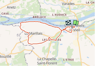
Trail Walking of 14.7 km to be discovered at Pays de la Loire, Maine-et-Loire, Mauges-sur-Loire. This trail is proposed by neoroll44.
Description
Départ: Parking de Notre-Dame du Marillais.
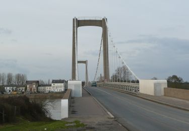
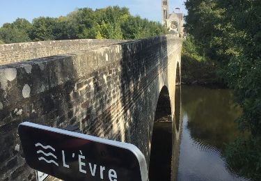
(D/A) Partir Ouest-Sud-Ouest en direction du Marillais et passer le pont sur l'Èvre.
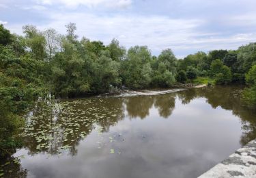
(1) Au sortir du pont, prendre le chemin à gauche. Longer l'Èvre pour rejoindre le lieu-dit Les Brosses.
(2) Traverser la route et effectuer un droite/gauche pour prendre le chemin qui mène au Clos de la Lande.
(3) Tourner à gauche puis obliquer dans le deuxième chemin à droite (Chemin des Potiers) qui passe devant la croix de Navarre.
(4) Traverser la route et suivre le 'GR®3 jusqu'à un chemin sur la droite (possibilité d'un raccourci : voir dans les Informations pratiques).
(5) Quitter le GR®3 et poursuivre à droite sur le chemin de terre. Traverser une route et continuer tout droit jusqu'à la D571.
(6) La traverser avec prudence et poursuivre en face. Au croisement suivant, continuer tout droit jusqu'à une autre route (raccourci en informations pratiques).
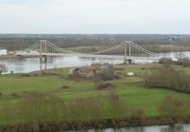
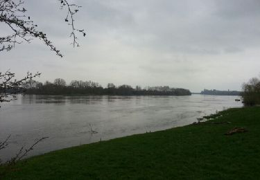
(7) Suivre la route à gauche et ensuite la première route à droite qui conduit à la Loire.
(9) Suivre à droite le sentier qui longe le fleuve. Cheminer longuement en bord de Loire et aboutir à l'escalier qui remonte vers le pont emprunté à l'aller.
(1) Repasser sur le pont sur l'Evre et aller tout droit jusqu'au parking de Notre-Dame du Marillais (D/A).
Points of interest
Positioning
Comments
Trails nearby
![Trail On foot Mauges-sur-Loire - circuit Èvre et Loire - Photo](https://media.geolcdn.com/t/375/260/f255744a-c2b8-42bc-a3a3-2a6951099acb.jpeg&format=jpg&maxdim=2)
![On foot On foot](https://static1.geolcdn.com/sitytour/trail-icons/100.png)
On foot
![](/images/other/stat-length.png)
![](https://static1.geolcdn.com/siteimages/upload/files/16400158638029165_repeat_loop_refresh_sync_direction_icon.png)
![Trail On foot Loireauxence - Les Coteaux de Bray - Photo](https://media.geolcdn.com/t/375/260/add5f107-e346-450c-af84-75ce09a32a4d.jpeg&format=jpg&maxdim=2)
![On foot On foot](https://static1.geolcdn.com/sitytour/trail-icons/100.png)
On foot
![](/images/other/stat-length.png)
![](https://static1.geolcdn.com/siteimages/upload/files/16400158638029165_repeat_loop_refresh_sync_direction_icon.png)
![Trail On foot Montrelais - La Grande Verrière - Photo](https://media.geolcdn.com/t/375/260/add5f107-e346-450c-af84-75ce09a32a4d.jpeg&format=jpg&maxdim=2)
![On foot On foot](https://static1.geolcdn.com/sitytour/trail-icons/100.png)
On foot
![](/images/other/stat-length.png)
![](https://static1.geolcdn.com/siteimages/upload/files/16400158638029165_repeat_loop_refresh_sync_direction_icon.png)
![Trail On foot Loireauxence - Circuit de la Madeleine - Photo](https://media.geolcdn.com/t/375/260/81763910-4ba0-4746-a2b5-2cd2ed4261f9.jpeg&format=jpg&maxdim=2)
![On foot On foot](https://static1.geolcdn.com/sitytour/trail-icons/100.png)
On foot
![](/images/other/stat-length.png)
![](https://static1.geolcdn.com/siteimages/upload/files/16400158638029165_repeat_loop_refresh_sync_direction_icon.png)
![Trail Walking Mauges-sur-Loire - Saint Florent le Vieil - Photo](https://media.geolcdn.com/t/375/260/6afcac4c-6eed-46e8-925f-dd93c5c1cdb6.jpg&format=jpg&maxdim=2)
![Walking Walking](https://static1.geolcdn.com/sitytour/trail-icons/101.png)
Walking
![](/images/other/stat-length.png)
![](https://static1.geolcdn.com/siteimages/upload/files/16400158638029165_repeat_loop_refresh_sync_direction_icon.png)
![Trail Other activity Mauges-sur-Loire - saint Florent le vieil - Photo](https://media.geolcdn.com/t/375/260/ext.jpg?maxdim=2&url=https%3A%2F%2Fservices.sitytrail.com%2FGeolivesWS%2FDownloadMedia.ashx%3FTrailID%3D1047813%26Media%3D20180928143351.jpg)
![Other activity Other activity](https://static1.geolcdn.com/sitytour/trail-icons/900.png)
Other activity
![](/images/other/stat-length.png)
![](https://static1.geolcdn.com/siteimages/upload/files/16400158638029165_repeat_loop_refresh_sync_direction_icon.png)
![Trail Walking Mauges-sur-Loire - notre Dame du Marillais - Photo](https://media.geolcdn.com/t/375/260/ext.jpg?maxdim=2&url=https%3A%2F%2Fservices.sitytrail.com%2FGeolivesWS%2FDownloadMedia.ashx%3FTrailID%3D548376%26Media%3Dfix__20160402171808.jpg)
![Walking Walking](https://static1.geolcdn.com/sitytour/trail-icons/101.png)
Walking
![](/images/other/stat-length.png)
![](https://static1.geolcdn.com/siteimages/upload/files/16400158638029165_repeat_loop_refresh_sync_direction_icon.png)
![Trail Walking Mauges-sur-Loire - notre Dame du Marillais - Photo](https://media.geolcdn.com/t/375/260/ext.jpg?maxdim=2&url=https%3A%2F%2Fservices.sitytrail.com%2FGeolivesWS%2FDownloadMedia.ashx%3FTrailID%3D547961%26Media%3Dfix__20160402164253.jpg)
![Walking Walking](https://static1.geolcdn.com/sitytour/trail-icons/101.png)
Walking
![](/images/other/stat-length.png)
![](https://static1.geolcdn.com/siteimages/upload/files/16400158638029165_repeat_loop_refresh_sync_direction_icon.png)
![Trail Bicycle tourism Loireauxence - SityTrail - Loire à Vélo Nantes - Ponts-de-Cé_J1 & J2 - Photo](https://media.geolcdn.com/t/375/260/ext.jpg?maxdim=2&url=https%3A%2F%2Fstatic1.geolcdn.com%2Fsiteimages%2Fupload%2Ffiles%2F1524743154velo.jpg)
![Bicycle tourism Bicycle tourism](https://static1.geolcdn.com/sitytour/trail-icons/204.png)
Bicycle tourism
![](/images/other/stat-length.png)
![](https://static1.geolcdn.com/siteimages/upload/files/16400158638029165_repeat_loop_refresh_sync_direction_icon.png)