Trail Walking Cazères-sur-l'Adour - lac du Gioule - Photo
© OpenStreetMap contributors
Length
Length
12.1 km
Max alt
Max alt
144 m
Uphill gradient
Uphill gradient
205 m
Km-Effort
Km-Effort  
14.9 km
Min alt
Min alt
90 m
Downhill gradient
Downhill gradient
205 m
Boucle
Boucle
Yes
Creation date :
2024-09-07 07:08:52.922
Updated on :
2024-09-09 09:05:08.724

(0 Reviews)

Walking
Walking
3h34
Difficulty : Difficult

Scan this QR Code to open this trail in the SityTrail application

FREE GPS app for hiking

Logo SityTrail SityTrail

IGN / Geographical institutes

Download SityTrail from the App Store Download SityTrail from Google Play

Logo SityTrail SityTrail World

The world is yours!

Download SityTrail from the App Store Download SityTrail from Google Play Download SityTrail on Huawei AppGallery

About

Trail Walking of 12.1 km to be discovered at New Aquitaine, Landes, Cazères-sur-l'Adour. This trail is proposed by artalens40.

Description

Le Vignau

Elevation profile

Positioning

Country:
France
Region :
New Aquitaine
Department/Province :
Landes
Municipality :
Cazères-sur-l'Adour
Location:
Unknown
Start:(UTM)
719811 ; 4849823 (30T) N.

Trails nearby

Trail Walking Lussagnet - balade Lussagnet - Photo
Walking
Brigitte Subrenat

Walking

Difficult
Lussagnet, New Aquitaine, Landes, France
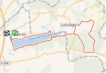
10.8 km | 13.4 km-effort
3h 0min
Yes
Trail Walking Duhort-Bachen - vallons du lourden - Photo
Walking
papiou

Walking

Medium
Duhort-Bachen, New Aquitaine, Landes, France
5.7 km | 6.8 km-effort
1h 30min
Yes
Trail Walking Cazères-sur-l'Adour - Boucle de Cazères sur l’Adour - Photo
Walking
611686735

Walking

Very easy
Cazères-sur-l'Adour, New Aquitaine, Landes, France
8 km | 9 km-effort
2h 0min
Yes


Close
My subscriptions