Trail Walking Saint-Léger-de-Peyre - St lLeger de Peyre - Photo
 tyntyn
tyntyn

User

© OpenStreetMap contributors
Length
Length
12.8 km
Max alt
Max alt
1130 m
Uphill gradient
Uphill gradient
485 m
Km-Effort
Km-Effort  
19.3 km
Min alt
Min alt
721 m
Downhill gradient
Downhill gradient
486 m
Boucle
Boucle
Yes
Creation date :
2024-09-06 08:48:13.862
Updated on :
2024-09-06 13:25:34.065

(0 Reviews)

Walking
Walking
4h13
Difficulty : Very difficult

Scan this QR Code to open this trail in the SityTrail application

FREE GPS app for hiking

Logo SityTrail SityTrail

IGN / Geographical institutes

Download SityTrail from the App Store Download SityTrail from Google Play

Logo SityTrail SityTrail World

The world is yours!

Download SityTrail from the App Store Download SityTrail from Google Play Download SityTrail on Huawei AppGallery

About

Trail Walking of 12.8 km to be discovered at Occitania, Lozère, Saint-Léger-de-Peyre. This trail is proposed by tyntyn.

Elevation profile

Photos

Positioning

Country:
France
Region :
Occitania
Department/Province :
Lozère
Municipality :
Saint-Léger-de-Peyre
Location:
Unknown
Start:(UTM)
523884 ; 4937839 (31T) N.

Trails nearby

Trail Walking Saint-Léger-de-Peyre - circuit de St léger de peyre  les loup. - Photo
Walking
GILOU440

Walking

Difficult
Saint-Léger-de-Peyre, Occitania, Lozère, France
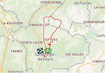
8.9 km | 14.3 km-effort
3h 33min
Yes
Trail Mountain bike Marvejols - Fait GTMC 2022 E11 Bigose - Photo
Mountain bike
jl77130

Mountain bike

Medium
Marvejols, Occitania, Lozère, France
55 km | 71 km-effort
7h 22min
No
Trail Other activity Marvejols - test  - Photo
Other activity
couchetounu

Other activity

Very easy
Marvejols, Occitania, Lozère, France
10 km | 13.3 km-effort
27min
No
Trail Walking Saint-Léger-de-Peyre - St léger de peyre Espère  - Photo
Walking
Jérôme Pignol

Walking

Medium
Saint-Léger-de-Peyre, Occitania, Lozère, France
6.5 km | 11 km-effort
2h 30min
Yes
Trail Walking Saint-Léger-de-Peyre - St Léger le peyre - Photo
Walking
guitounette

Walking

Very difficult
Saint-Léger-de-Peyre, Occitania, Lozère, France
15.1 km | 22 km-effort
5h 33min
No
Trail Moto cross Marvejols - trail rando Yamaha  - Photo
Moto cross
Jérôme Pignol

Moto cross

Easy
Marvejols, Occitania, Lozère, France
34 km | 47 km-effort
1083h 3min
No
Trail Horseback riding Antrenas - le mazel Bigose 30.8 km - Photo
Horseback riding
Lozère Cheval

Horseback riding

Very easy
Antrenas, Occitania, Lozère, France
31 km | 40 km-effort
Unknown
No
Trail Walking Le Buisson - Gite de Sagnebesse - loups du Gevaudan - Photo
Walking
vertygo

Walking

Very easy
Le Buisson, Occitania, Lozère, France
8.1 km | 9.8 km-effort
2h 29min
Yes
Trail Walking Le Buisson - Gite de Sagnebesse -  loups du Gevaudan - Sainte Luce - Photo
Walking
vertygo

Walking

Very easy
Le Buisson, Occitania, Lozère, France
9.9 km | 12.5 km-effort
3h 3min
Yes


Close
My subscriptions