j9 Bath SityTrail > Trails > Outdoor > United Kingdom > England > Bath and North East Somerset > Unknown SityTrail > Trails > Outdoor > United Kingdom > England > Bath and North East Somerset > Unknown j9 Bath himpececilia User 3D © OpenStreetMap contributors Length 12.5 km Max alt 119 m Uphill gradient 162 m Km-Effort 14.6 km Min alt 16 m Downhill gradient 159 m Boucle No Creation date : 2024-09-04 08:19:16.278 Updated on : 2024-09-11 09:17:22.752 (0 Reviews) Walking 3h01 Difficulty : Difficult FREE GPS app for hiking SityTrail IGN / Geographical institutes SityTrail World The world is yours! About 
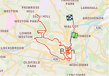
Trail Walking of 12.5 km to be discovered at England, Bath and North East Somerset. This trail is proposed by himpececilia. Legends | More details (PDF) Elevation profile Legends > 15% 15% - 10% 10% - 5% flat 5% - 10% 10% - 15% 15% - 30% > 30% Positioning Country: United Kingdom Region : England Department/Province : Bath and North East Somerset Municipality : Unknown Location: Unknown Start:(Dec) 51.3844574 / -2.357872 Start:(UTM) 544684 ; 5692775 (30U) N. Comments Please log in to post a review or rate the element Trails nearby GUIDE+ Bath Skyline On foot Easy , England, Bath and North East Somerset, United Kingdom 9.3 km | 12 km-effort 2h 43min Yes himpececilia j8 Bradford on avon Walking Medium , England, Bath and North East Somerset, United Kingdom 9.9 km | 11.4 km-effort 2h 35min No himpececilia j7 Bath Skyline, vergers, cimetière Walking Difficult , England, Bath and North East Somerset, United Kingdom 10.7 km | 14.1 km-effort 3h 11min Yes