Trail Moto cross Peyrestortes - 2024_10_12_ Peyrestortes - Photo
© OpenStreetMap contributors
Length
Length
74 km
Max alt
Max alt
452 m
Uphill gradient
Uphill gradient
1924 m
Km-Effort
Km-Effort  
100 km
Min alt
Min alt
35 m
Downhill gradient
Downhill gradient
1924 m
Boucle
Boucle
Yes
Creation date :
2024-09-01 14:51:36.298
Updated on :
2024-09-01 14:54:54.683

(0 Reviews)

Moto cross
Moto cross
0m
Difficulty : Very easy

Scan this QR Code to open this trail in the SityTrail application

FREE GPS app for hiking

Logo SityTrail SityTrail

IGN / Geographical institutes

Download SityTrail from the App Store Download SityTrail from Google Play

Logo SityTrail SityTrail World

The world is yours!

Download SityTrail from the App Store Download SityTrail from Google Play Download SityTrail on Huawei AppGallery

About

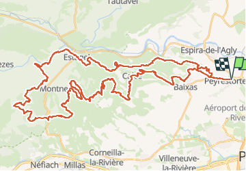
Trail Moto cross of 74 km to be discovered at Occitania, Pyrénées-Orientales, Peyrestortes. This trail is proposed by the_brain.

Elevation profile

Positioning

Country:
France
Region :
Occitania
Department/Province :
Pyrénées-Orientales
Municipality :
Peyrestortes
Location:
Unknown
Start:(UTM)
488172 ; 4733645 (31T) N.

Trails nearby

Trail Walking Saint-Estève - SAINT-ESTEVE 66 - ballade dans le Vignoble de Rivesaltes  - Photo
Walking
jeff66

Walking

Medium
(1)
Saint-Estève, Occitania, Pyrénées-Orientales, France
8 km | 8.8 km-effort
1h 23min
Yes
Trail Walking Baixas - baixas chapelle ste catherine - Photo
Walking
66Gribouille83

Walking

Difficult
Baixas, Occitania, Pyrénées-Orientales, France
9.5 km | 12.9 km-effort
3h 56min
Yes
Trail Walking Baixas - Boucle Baixas Calce  - Photo
Walking
ombrabella

Walking

Very easy
Baixas, Occitania, Pyrénées-Orientales, France
14.3 km | 18.8 km-effort
3h 41min
Yes
Trail Walking Rivesaltes - 66 RIVESALTES promenade dans la cite, la vieille ville et rives d'Agly - Photo
Walking
jeff66

Walking

Easy
Rivesaltes, Occitania, Pyrénées-Orientales, France
5.2 km | 5.6 km-effort
1h 5min
Yes
Trail Walking Perpignan - 66 PERPIGNAN polygone nord au Haut Vernet - Photo
Walking
jeff66

Walking

Medium
Perpignan, Occitania, Pyrénées-Orientales, France
10.4 km | 11 km-effort
1h 57min
Yes
Trail Walking Baho - 66 SAINT-ESTEVE, jusqu'aux Abords de BAIXAS, par les sentiers à travers vignes et parc éoliennes  - Photo
Walking
jeff66

Walking

Medium
Baho, Occitania, Pyrénées-Orientales, France
12.3 km | 13.4 km-effort
2h 12min
Yes
Trail Walking Espira-de-l'Agly - 66 ESPIPA DE L'AGLY, promenade entre vignes, pinèdes et garrigues - Photo
Walking
jeff66

Walking

Medium
(1)
Espira-de-l'Agly, Occitania, Pyrénées-Orientales, France
9.9 km | 12.7 km-effort
2h 7min
Yes
Trail Walking Baixas - 66 BAIXAS à CALCE chemins à travers le vignoble - Photo
Walking
jeff66

Walking

Medium
Baixas, Occitania, Pyrénées-Orientales, France
14.4 km | 17.8 km-effort
2h 39min
Yes
Trail Walking Rivesaltes - 66 RIVESALTES - promenade le long de l'Agly - Photo
Walking
jeff66

Walking

Very easy
Rivesaltes, Occitania, Pyrénées-Orientales, France
4.3 km | 4.6 km-effort
44min
Yes


Close
My subscriptions