![](/images/other/stat-length.png)
![Trail Nordic walking Saint-Christophe-d'Allier - J2 - MN 16km Boucle France - Le Trémoul - St Christophe d'Allier - Plage des gorges de L'Allier - Le Ménial - Photo](https://media.geolcdn.com/t/1900/400/6e9ab436-c602-4e3d-a713-3062640ee8a6.jpg&format=pjpeg&maxdim=2)
J2 - MN 16km Boucle France - Le Trémoul - St Christophe d'Allier - Plage des gorges de L'Allier - Le Ménial
JJG91
User
![Length](/images/other/stat-length.png)
Length
15.9 km
![Max alt](https://static1.geolcdn.com/siteimages/upload/files/1508320355ic_sort_altitude_max_24dp.png)
Max alt
1076 m
![Uphill gradient](https://static1.geolcdn.com/siteimages/upload/files/1508320355ic_sort_den_pos_24dp.png)
Uphill gradient
561 m
![Km-Effort](/images/other/stat-length.png)
Km-Effort
23 km
![Min alt](https://static1.geolcdn.com/siteimages/upload/files/1508320355ic_sort_altitude_min_24dp.png)
Min alt
697 m
![Downhill gradient](https://static1.geolcdn.com/siteimages/upload/files/1508320355ic_sort_den_neg_24dp.png)
Downhill gradient
560 m
![Boucle](https://static1.geolcdn.com/siteimages/upload/files/16400158638029165_repeat_loop_refresh_sync_direction_icon.png)
Boucle
Yes
Creation date :
2024-09-01 08:37:06.622
Updated on :
2025-02-07 10:28:49.444
![Nordic walking](https://static1.geolcdn.com/sitytour/trail-icons/102.png)
0m
Difficulty : Medium
![Scan this QR Code to open this trail in the SityTrail application](https://capi.geolives.com/qq0zvz2zws4bq2lad0pu/sitytour/trails/4175567/qr.png?size=200)
FREE GPS app for hiking
About
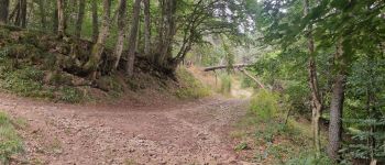
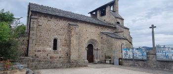
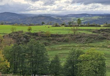
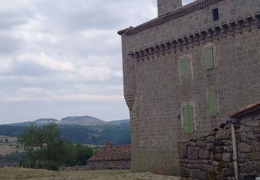
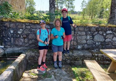
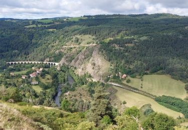
Trail Nordic walking of 15.9 km to be discovered at Auvergne-Rhône-Alpes, Haute-Loire, Saint-Christophe-d'Allier. This trail is proposed by JJG91.
Description
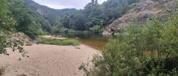
MN de 16km - Boucle France - Le Trémoul - St Christophe d'Allier - Plage des gorges de L'Allier - Le Ménial séjour Rcy Gévaudan juin 2025 Jour 2
Positioning
Country:
France
Region :
Auvergne-Rhône-Alpes
Department/Province :
Haute-Loire
Municipality :
Saint-Christophe-d'Allier
Location:
Unknown
Start:(Dec)
Start:(UTM)
554848 ; 4965232 (31T) N.
Comments
Trails nearby
![Trail Walking Saint-Haon - le nouveau Monde - Photo](https://media.geolcdn.com/t/375/260/cca55de8-54d4-44a4-a902-d24b301019d1.jpg&format=jpg&maxdim=2)
![Walking Walking](https://static1.geolcdn.com/sitytour/trail-icons/101.png)
le nouveau Monde
Walking
Medium
Saint-Haon,
Auvergne-Rhône-Alpes,
Haute-Loire,
France
![](/images/other/stat-length.png)
9.1 km | 13.3 km-effort
2h 52min
![](https://static1.geolcdn.com/siteimages/upload/files/16400158638029165_repeat_loop_refresh_sync_direction_icon.png)
Yes
![Trail Walking Saint Bonnet-Laval - Le Chapeauroux - Photo](https://media.geolcdn.com/t/375/260/b2c70220-9c39-4284-a14e-fcd494cd5a83.jpg&format=jpg&maxdim=2)
![Walking Walking](https://static1.geolcdn.com/sitytour/trail-icons/101.png)
Le Chapeauroux
Walking
Medium
Saint Bonnet-Laval,
Occitania,
Lozère,
France
![](/images/other/stat-length.png)
14.3 km | 21 km-effort
4h 41min
![](https://static1.geolcdn.com/siteimages/upload/files/16400158638029165_repeat_loop_refresh_sync_direction_icon.png)
Yes
![Trail On foot Saint-Christophe-d'Allier - Les bords de l'Allier - Photo](https://media.geolcdn.com/t/375/260/ext.jpg?maxdim=2&url=https%3A%2F%2Fstatic1.geolcdn.com%2Fsiteimages%2Fupload%2Ffiles%2F1545311037marcheuse_200dpi.jpg)
![On foot On foot](https://static1.geolcdn.com/sitytour/trail-icons/100.png)
Les bords de l'Allier
On foot
Easy
Saint-Christophe-d'Allier,
Auvergne-Rhône-Alpes,
Haute-Loire,
France
![](/images/other/stat-length.png)
9.8 km | 13.4 km-effort
3h 3min
![](https://static1.geolcdn.com/siteimages/upload/files/16400158638029165_repeat_loop_refresh_sync_direction_icon.png)
Yes
![Trail Walking Saint Bonnet-Laval - chapeauroux - Photo](https://media.geolcdn.com/t/375/260/e54c4eca-018a-4f59-ac4d-0ccf88814d10.jpg&format=jpg&maxdim=2)
![Walking Walking](https://static1.geolcdn.com/sitytour/trail-icons/101.png)
chapeauroux
Walking
Difficult
Saint Bonnet-Laval,
Occitania,
Lozère,
France
![](/images/other/stat-length.png)
17 km | 26 km-effort
5h 58min
![](https://static1.geolcdn.com/siteimages/upload/files/16400158638029165_repeat_loop_refresh_sync_direction_icon.png)
No
![Trail Walking Bel-Air-Val-d'Ance - chambon le chateau - Photo](https://media.geolcdn.com/t/375/260/ext.jpg?maxdim=2&url=https%3A%2F%2Fstatic1.geolcdn.com%2Fsiteimages%2Fupload%2Ffiles%2F1553511878bg_sport_marche.png)
![Walking Walking](https://static1.geolcdn.com/sitytour/trail-icons/101.png)
chambon le chateau
Walking
Medium
Bel-Air-Val-d'Ance,
Occitania,
Lozère,
France
![](/images/other/stat-length.png)
8.7 km | 10.9 km-effort
2h 18min
![](https://static1.geolcdn.com/siteimages/upload/files/16400158638029165_repeat_loop_refresh_sync_direction_icon.png)
Yes
![Trail Mountain bike Saint-Christophe-d'Allier - Sodo fin rouluraid 2024 - Photo](https://media.geolcdn.com/t/375/260/ext.jpg?maxdim=2&url=https%3A%2F%2Fstatic1.geolcdn.com%2Fsiteimages%2Fupload%2Ffiles%2F1524743154velo.jpg)
![Mountain bike Mountain bike](https://static1.geolcdn.com/sitytour/trail-icons/202.png)
Sodo fin rouluraid 2024
Mountain bike
Easy
Saint-Christophe-d'Allier,
Auvergne-Rhône-Alpes,
Haute-Loire,
France
![](/images/other/stat-length.png)
12.4 km | 16.2 km-effort
2h 4min
![](https://static1.geolcdn.com/siteimages/upload/files/16400158638029165_repeat_loop_refresh_sync_direction_icon.png)
Yes
![Trail Walking Saint Bonnet-Laval - GR470 Chapeauroux/Landos - Photo](https://media.geolcdn.com/t/375/260/ext.jpg?maxdim=2&url=https%3A%2F%2Fstatic1.geolcdn.com%2Fsiteimages%2Fupload%2Ffiles%2F1553511878bg_sport_marche.png)
![Walking Walking](https://static1.geolcdn.com/sitytour/trail-icons/101.png)
GR470 Chapeauroux/Landos
Walking
Difficult
Saint Bonnet-Laval,
Occitania,
Lozère,
France
![](/images/other/stat-length.png)
12.4 km | 18.1 km-effort
4h 7min
![](https://static1.geolcdn.com/siteimages/upload/files/16400158638029165_repeat_loop_refresh_sync_direction_icon.png)
No
![Trail Walking Saint Bonnet-Laval - GR470 Chapeyroux/Langogne - Photo](https://media.geolcdn.com/t/375/260/ext.jpg?maxdim=2&url=https%3A%2F%2Fstatic1.geolcdn.com%2Fsiteimages%2Fupload%2Ffiles%2F1553511878bg_sport_marche.png)
![Walking Walking](https://static1.geolcdn.com/sitytour/trail-icons/101.png)
GR470 Chapeyroux/Langogne
Walking
Very difficult
Saint Bonnet-Laval,
Occitania,
Lozère,
France
![](/images/other/stat-length.png)
20 km | 31 km-effort
6h 55min
![](https://static1.geolcdn.com/siteimages/upload/files/16400158638029165_repeat_loop_refresh_sync_direction_icon.png)
No
![Trail Walking Saint Bonnet-Laval - gr 470 - Photo](https://media.geolcdn.com/t/375/260/dd708ef6-f9d1-4334-89e6-4edeb9d92769.jpg&format=jpg&maxdim=2)
![Walking Walking](https://static1.geolcdn.com/sitytour/trail-icons/101.png)
gr 470
Walking
Medium
Saint Bonnet-Laval,
Occitania,
Lozère,
France
![](/images/other/stat-length.png)
13.4 km | 19.2 km-effort
4h 42min
![](https://static1.geolcdn.com/siteimages/upload/files/16400158638029165_repeat_loop_refresh_sync_direction_icon.png)
No