Trail Cycle Serdinya - La Bastide d'Olette # - Photo
 RjR
RjR

User

© OpenStreetMap contributors
Length
Length
4.1 km
Max alt
Max alt
591 m
Uphill gradient
Uphill gradient
43 m
Km-Effort
Km-Effort  
4.8 km
Min alt
Min alt
523 m
Downhill gradient
Downhill gradient
89 m
Boucle
Boucle
No
Creation date :
2017-05-29 00:00:00.0
Updated on :
2017-05-29 00:00:00.0

(0 Reviews)

Cycle
Cycle
18m
Difficulty : Easy

Scan this QR Code to open this trail in the SityTrail application

FREE GPS app for hiking

Logo SityTrail SityTrail

IGN / Geographical institutes

Download SityTrail from the App Store Download SityTrail from Google Play

Logo SityTrail SityTrail World

The world is yours!

Download SityTrail from the App Store Download SityTrail from Google Play Download SityTrail on Huawei AppGallery

About

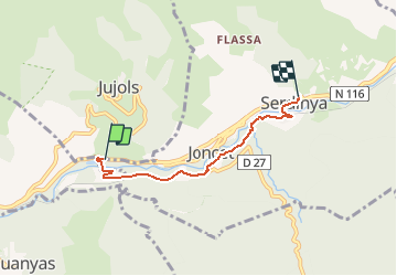
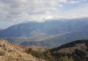
Trail Cycle of 4.1 km to be discovered at Occitania, Pyrénées-Orientales, Serdinya. This trail is proposed by RjR.

Description

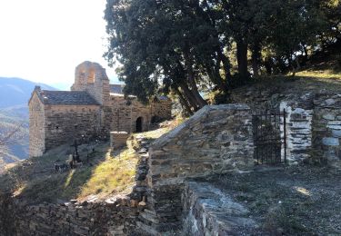
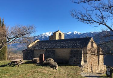
Itinéraire longeant la voie du train jaune. N 116 -> La Bastide d'Olette -> Joncet el Bac, par chemin vélos & voitures, puis route D27 (à Escaro / Sahorre) -> Joncet el Bac, chapelle -> Serdinya,
par route goudronnée. -> N 116.

Elevation profile

Points of interest

Point of interest Olette - maison du P N R - Photo
RjR
Point of interest Serdinya - barrière levante - Photo
RjR
Point of interest Serdinya - barrière levante - Photo
RjR
Point of interest Serdinya - train - Photo
RjR
SERDINYA 
Point of interest Serdinya - voie - Photo
RjR
SERDINYA 
Point of interest Serdinya - voie - Photo
RjR
SERDINYA 
Point of interest Serdinya - route - Photo
RjR
SERDINYA 
Point of interest Serdinya - route - Photo
RjR
SERDINYA 
Point of interest Serdinya - route - Photo
RjR
SERDINYA 
Point of interest Serdinya - rue - Photo
RjR
SERDINYA 
Point of interest Serdinya - rue - Photo
RjR
SERDINYA 
Point of interest Serdinya - église - Photo
RjR
SERDINYA 

Positioning

Country:
France
Region :
Occitania
Department/Province :
Pyrénées-Orientales
Municipality :
Serdinya
Location:
Unknown
Start:(UTM)
441966 ; 4712383 (31T) N.

Trails nearby

Trail Walking Olette - Evol village et chateau ( Olette) - Photo
Walking
Joël.cof

Walking

Easy
(1)
Olette, Occitania, Pyrénées-Orientales, France
3.2 km | 5.6 km-effort
1h 16min
Yes
Trail Walking Jujols - Jujols 1 - Photo
Walking
jcmartin

Walking

Medium
(1)
Jujols, Occitania, Pyrénées-Orientales, France
13.2 km | 22 km-effort
4h 2min
Yes
Trail Walking Jujols - jujols marbre rouge  - Photo
Walking
66Gribouille83

Walking

Very difficult
Jujols, Occitania, Pyrénées-Orientales, France
16.5 km | 28 km-effort
9h 13min
Yes
Trail Walking Sahorre - Thorrent - Py et le Rec de Thorrent - Photo
Walking
Jean-marie Compta

Walking

Medium
Sahorre, Occitania, Pyrénées-Orientales, France
18.5 km | 30 km-effort
5h 33min
Yes
Trail Walking Canaveilles - 20221120 Canaveilles - Llar  - Photo
Walking
ThonyM

Walking

Medium
Canaveilles, Occitania, Pyrénées-Orientales, France
11 km | 20 km-effort
3h 15min
Yes
Trail Walking Serdinya - flassa. taratera 850 positif 13km 4h30 - Photo
Walking
Erius

Walking

Very difficult
Serdinya, Occitania, Pyrénées-Orientales, France
13.8 km | 25 km-effort
4h 21min
Yes
Trail Walking Fuilla - 20220112 horts  - Photo
Walking
ThonyM

Walking

Difficult
Fuilla, Occitania, Pyrénées-Orientales, France
14.6 km | 27 km-effort
4h 31min
Yes
Trail Walking Olette - 20211216 Olette - Photo
Walking
ThonyM

Walking

Medium
Olette, Occitania, Pyrénées-Orientales, France
16 km | 28 km-effort
5h 8min
Yes
Trail Walking Escaro - 20210530 au départ du col de Fins - Photo
Walking
ThonyM

Walking

Difficult
Escaro, Occitania, Pyrénées-Orientales, France
19.3 km | 38 km-effort
6h 3min
Yes


Close
My subscriptions