![](/images/other/stat-length.png)
![Trail Walking Chalmazel-Jeansagnière - Au dessus de Chalmazel - Photo](https://media.geolcdn.com/t/1900/400/25e3078d-228b-4291-af75-c67ea03e26dc.jpg&format=pjpeg&maxdim=2)
Au dessus de Chalmazel
dudu42
User GUIDE
![Length](/images/other/stat-length.png)
Length
18.4 km
![Max alt](https://static1.geolcdn.com/siteimages/upload/files/1508320355ic_sort_altitude_max_24dp.png)
Max alt
1171 m
![Uphill gradient](https://static1.geolcdn.com/siteimages/upload/files/1508320355ic_sort_den_pos_24dp.png)
Uphill gradient
681 m
![Km-Effort](/images/other/stat-length.png)
Km-Effort
27 km
![Min alt](https://static1.geolcdn.com/siteimages/upload/files/1508320355ic_sort_altitude_min_24dp.png)
Min alt
850 m
![Downhill gradient](https://static1.geolcdn.com/siteimages/upload/files/1508320355ic_sort_den_neg_24dp.png)
Downhill gradient
681 m
![Boucle](https://static1.geolcdn.com/siteimages/upload/files/16400158638029165_repeat_loop_refresh_sync_direction_icon.png)
Boucle
Yes
Creation date :
2024-08-25 07:17:08.265
Updated on :
2024-08-25 12:05:05.864
![Walking](https://static1.geolcdn.com/sitytour/trail-icons/101.png)
4h25
Difficulty : Medium
![Scan this QR Code to open this trail in the SityTrail application](https://capi.geolives.com/qq0zvz2zws4bq2lad0pu/sitytour/trails/4167820/qr.png?size=200)
FREE GPS app for hiking
About
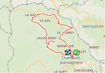
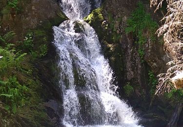
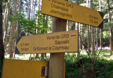
Trail Walking of 18.4 km to be discovered at Auvergne-Rhône-Alpes, Loire, Chalmazel-Jeansagnière. This trail is proposed by dudu42.
Description
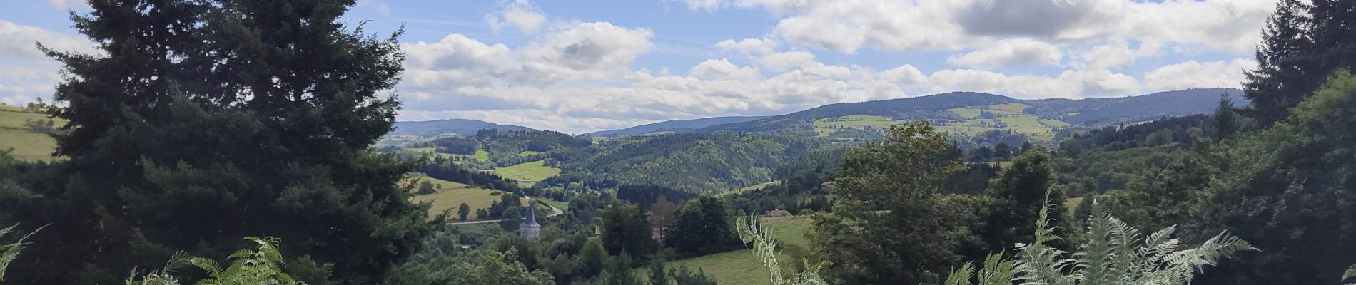
Très bon parcours mi ombragé.
Beaux points de vue sur les montagnes du Livradois Forez.
Peu de monde.
Positioning
Country:
France
Region :
Auvergne-Rhône-Alpes
Department/Province :
Loire
Municipality :
Chalmazel-Jeansagnière
Location:
Chalmazel
Start:(Dec)
Start:(UTM)
566373 ; 5061461 (31T) N.
Comments
Trails nearby
![Trail Walking Saint-Just-en-Bas - Morière - Photo](https://media.geolcdn.com/t/375/260/ext.jpg?maxdim=2&url=https%3A%2F%2Fstatic1.geolcdn.com%2Fsiteimages%2Fupload%2Ffiles%2F1553511878bg_sport_marche.png)
![Walking Walking](https://static1.geolcdn.com/sitytour/trail-icons/101.png)
Morière
Walking
Easy
(1)
Saint-Just-en-Bas,
Auvergne-Rhône-Alpes,
Loire,
France
![](/images/other/stat-length.png)
13.3 km | 20 km-effort
4h 13min
![](https://static1.geolcdn.com/siteimages/upload/files/16400158638029165_repeat_loop_refresh_sync_direction_icon.png)
Yes
![Trail Walking Saint-Just-en-Bas - St Just en Bas - Photo](https://media.geolcdn.com/t/375/260/ext.jpg?maxdim=2&url=https%3A%2F%2Fservices.sitytrail.com%2FGeolivesWS%2FDownloadMedia.ashx%3FTrailID%3D343718%26Media%3D20130402163639.jpg)
![Walking Walking](https://static1.geolcdn.com/sitytour/trail-icons/101.png)
St Just en Bas
Walking
Medium
Saint-Just-en-Bas,
Auvergne-Rhône-Alpes,
Loire,
France
![](/images/other/stat-length.png)
9.8 km | 13.9 km-effort
2h 55min
![](https://static1.geolcdn.com/siteimages/upload/files/16400158638029165_repeat_loop_refresh_sync_direction_icon.png)
Yes
![Trail Walking Saint-Just-en-Bas - Départ de St Just en Bas - Photo](https://media.geolcdn.com/t/375/260/ext.jpg?maxdim=2&url=https%3A%2F%2Fservices.sitytrail.com%2FGeolivesWS%2FDownloadMedia.ashx%3FTrailID%3D183464%26Media%3D20130402163639.jpg)
![Walking Walking](https://static1.geolcdn.com/sitytour/trail-icons/101.png)
Départ de St Just en Bas
Walking
Medium
Saint-Just-en-Bas,
Auvergne-Rhône-Alpes,
Loire,
France
![](/images/other/stat-length.png)
9.8 km | 13.9 km-effort
2h 55min
![](https://static1.geolcdn.com/siteimages/upload/files/16400158638029165_repeat_loop_refresh_sync_direction_icon.png)
Yes
![Trail Running Chalmazel-Jeansagnière - Le Tour de La Pierre sur Haute par les plateaux - Photo](https://media.geolcdn.com/t/375/260/ext.jpg?maxdim=2&url=https%3A%2F%2Fservices.sitytrail.com%2FGeolivesWS%2FDownloadMedia.ashx%3FTrailID%3D172548%26Media%3D13912_6.jpg)
![Running Running](https://static1.geolcdn.com/sitytour/trail-icons/103.png)
Le Tour de La Pierre sur Haute par les plateaux
Running
Very difficult
Chalmazel-Jeansagnière,
Auvergne-Rhône-Alpes,
Loire,
France
![](/images/other/stat-length.png)
17 km | 24 km-effort
4h 0min
![](https://static1.geolcdn.com/siteimages/upload/files/16400158638029165_repeat_loop_refresh_sync_direction_icon.png)
Yes
![Trail Walking Chalmazel-Jeansagnière - Le Tour de La Pierre sur Haute par les plateaux - Photo](https://media.geolcdn.com/t/375/260/ext.jpg?maxdim=2&url=https%3A%2F%2Fservices.sitytrail.com%2FGeolivesWS%2FDownloadMedia.ashx%3FTrailID%3D172547%26Media%3D13912_6.jpg)
![Walking Walking](https://static1.geolcdn.com/sitytour/trail-icons/101.png)
Le Tour de La Pierre sur Haute par les plateaux
Walking
Very difficult
Chalmazel-Jeansagnière,
Auvergne-Rhône-Alpes,
Loire,
France
![](/images/other/stat-length.png)
17 km | 24 km-effort
6h 0min
![](https://static1.geolcdn.com/siteimages/upload/files/16400158638029165_repeat_loop_refresh_sync_direction_icon.png)
Yes
![Trail Walking Chalmazel-Jeansagnière - 220623-StJean.Vetre- Sapeau-Colombier - Photo](https://media.geolcdn.com/t/375/260/ext.jpg?maxdim=2&url=https%3A%2F%2Fstatic1.geolcdn.com%2Fsiteimages%2Fupload%2Ffiles%2F1553511878bg_sport_marche.png)
![Walking Walking](https://static1.geolcdn.com/sitytour/trail-icons/101.png)
220623-StJean.Vetre- Sapeau-Colombier
Walking
Medium
Chalmazel-Jeansagnière,
Auvergne-Rhône-Alpes,
Loire,
France
![](/images/other/stat-length.png)
6.7 km | 9.5 km-effort
2h 9min
![](https://static1.geolcdn.com/siteimages/upload/files/16400158638029165_repeat_loop_refresh_sync_direction_icon.png)
Yes
![Trail Moto cross Sauvain - Enduro Sauvain jour 2 - Photo](https://media.geolcdn.com/t/375/260/be7e4943-1c98-46fe-94b9-1b95d830221b.jpg&format=jpg&maxdim=2)
![Moto cross Moto cross](https://static1.geolcdn.com/sitytour/trail-icons/406.png)
Enduro Sauvain jour 2
Moto cross
Easy
Sauvain,
Auvergne-Rhône-Alpes,
Loire,
France
![](/images/other/stat-length.png)
69 km | 101 km-effort
2h 38min
![](https://static1.geolcdn.com/siteimages/upload/files/16400158638029165_repeat_loop_refresh_sync_direction_icon.png)
Yes
![Trail Moto cross Sauvain - enduro Sauvain jour 1 - Photo](https://media.geolcdn.com/t/375/260/6989c179-b591-4b60-9b0c-acd96e5d11ba.jpg&format=jpg&maxdim=2)
![Moto cross Moto cross](https://static1.geolcdn.com/sitytour/trail-icons/406.png)
enduro Sauvain jour 1
Moto cross
Easy
Sauvain,
Auvergne-Rhône-Alpes,
Loire,
France
![](/images/other/stat-length.png)
69 km | 98 km-effort
5h 12min
![](https://static1.geolcdn.com/siteimages/upload/files/16400158638029165_repeat_loop_refresh_sync_direction_icon.png)
Yes
![Trail Snowshoes Chalmazel-Jeansagnière - Jeansagniere - Photo](https://media.geolcdn.com/t/375/260/ext.jpg?maxdim=2&url=https%3A%2F%2Fstatic1.geolcdn.com%2Fsiteimages%2Fupload%2Ffiles%2F1524743153raquette.jpg)
![Snowshoes Snowshoes](https://static1.geolcdn.com/sitytour/trail-icons/504.png)
Jeansagniere
Snowshoes
Medium
Chalmazel-Jeansagnière,
Auvergne-Rhône-Alpes,
Loire,
France
![](/images/other/stat-length.png)
14.6 km | 20 km-effort
4h 24min
![](https://static1.geolcdn.com/siteimages/upload/files/16400158638029165_repeat_loop_refresh_sync_direction_icon.png)
Yes