Trail Walking La Grave - La Grave - La Meije - Ref Chancel et Belvédère  - Photo

La Grave - La Meije - Ref Chancel et Belvédère

 patjobou
patjobou

User

© OpenStreetMap contributors
Length
Length
4.6 km
Max alt
Max alt
2551 m
Uphill gradient
Uphill gradient
298 m
Km-Effort
Km-Effort  
8.4 km
Min alt
Min alt
2281 m
Downhill gradient
Downhill gradient
224 m
Boucle
Boucle
No
Creation date :
2024-08-21 10:28:16.427
Updated on :
2024-08-22 20:05:08.085

(0 Reviews)

Walking
Walking
2h01
Difficulty : Medium

Scan this QR Code to open this trail in the SityTrail application

FREE GPS app for hiking

Logo SityTrail SityTrail

IGN / Geographical institutes

Download SityTrail from the App Store Download SityTrail from Google Play

Logo SityTrail SityTrail World

The world is yours!

Download SityTrail from the App Store Download SityTrail from Google Play Download SityTrail on Huawei AppGallery

About

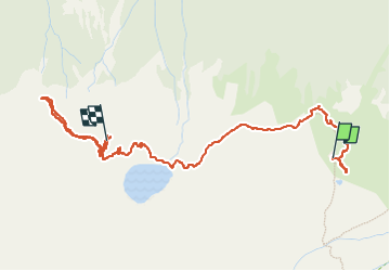
Trail Walking of 4.6 km to be discovered at Provence-Alpes-Côte d'Azur, Hautes-Alpes, La Grave. This trail is proposed by patjobou.

Description

Montée au Ref. Evariste Chancel à partir du 1er tronçon, A/R au belvédère qui vaut le dédétour.

Elevation profile

Photos

Positioning

Country:
France
Region :
Provence-Alpes-Côte d'Azur
Department/Province :
Hautes-Alpes
Municipality :
La Grave
Location:
Unknown
Start:(UTM)
286436 ; 4989404 (32T) N.

Trails nearby

Trail Walking Villar-d'Arêne - L'Aiguillon et Lac du Pontet 28.8.22  - Photo
Walking
GUIDE
fredetpascale

Walking

Very easy
(1)
Villar-d'Arêne, Provence-Alpes-Côte d'Azur, Hautes-Alpes, France
6 km | 9.4 km-effort
2h 0min
Yes
Trail Walking La Grave - L'aiguille du Goléon - Photo
Walking
tracegps

Walking

Very difficult
(1)
La Grave, Provence-Alpes-Côte d'Azur, Hautes-Alpes, France
9.1 km | 25 km-effort
5h 0min
No
Trail Walking La Grave - 05 lac goleon - Photo
Walking
GUIDE
randodyssée

Walking

Medium
La Grave, Provence-Alpes-Côte d'Azur, Hautes-Alpes, France
14.4 km | 28 km-effort
6h 2min
Yes
Trail Walking La Grave - 05 refuge e chancel - Photo
Walking
GUIDE
randodyssée

Walking

Medium
La Grave, Provence-Alpes-Côte d'Azur, Hautes-Alpes, France
11.4 km | 25 km-effort
7h 19min
No
Trail Walking La Grave - vallons de la Meije : lac Puy Vachère - Photo
Walking
GUIDE
nadinebondoux

Walking

Very difficult
La Grave, Provence-Alpes-Côte d'Azur, Hautes-Alpes, France
12.7 km | 27 km-effort
5h 44min
Yes
Trail On foot La Grave - Le Chazelet - Refuge du Pic du Mas de la Grave en boucle - Photo
On foot
GUIDE
Pierre Lefèvre

On foot

Easy
La Grave, Provence-Alpes-Côte d'Azur, Hautes-Alpes, France
9.9 km | 14.5 km-effort
2h 55min
Yes
Trail Walking Villar-d'Arêne - SityTrail - Lac du pontet et l'Aiguillon - Photo
Walking

Walking

Medium
(1)
Villar-d'Arêne, Provence-Alpes-Côte d'Azur, Hautes-Alpes, France
5.2 km | 8.6 km-effort
1h 56min
Yes
Trail Walking La Grave - 2020-09-03 Marche Tour de la Grave au plateau d'Emparis par le Pic du Mas de la Grave (3 jours) - Photo
Walking
GUIDE
holtzv

Walking

Medium
La Grave, Provence-Alpes-Côte d'Azur, Hautes-Alpes, France
51 km | 88 km-effort
17h 56min
No
Trail Walking La Grave - 2020-09-03 Marche La Grave au Refuge du Pic du Mas de la Grave - Photo
Walking
GUIDE
holtzv

Walking

Very easy
La Grave, Provence-Alpes-Côte d'Azur, Hautes-Alpes, France
12.2 km | 23 km-effort
4h 58min
No


Close
My subscriptions