Trail On foot Montfa - [Itinéraire] Randonnée des Puechs, sur les traces de Toulouse-Lautrec - Photo

[Itinéraire] Randonnée des Puechs, sur les traces de Toulouse-Lautrec

 tercla
tercla

User

© OpenStreetMap contributors
Length
Length
12.2 km
Max alt
Max alt
391 m
Uphill gradient
Uphill gradient
224 m
Km-Effort
Km-Effort  
15.2 km
Min alt
Min alt
248 m
Downhill gradient
Downhill gradient
224 m
Boucle
Boucle
Yes
Creation date :
2024-08-22 18:16:10.067
Updated on :
2024-08-22 18:17:11.041

(0 Reviews)

On foot
On foot
3h27
Difficulty : Easy

Scan this QR Code to open this trail in the SityTrail application

FREE GPS app for hiking

Logo SityTrail SityTrail

IGN / Geographical institutes

Download SityTrail from the App Store Download SityTrail from Google Play

Logo SityTrail SityTrail World

The world is yours!

Download SityTrail from the App Store Download SityTrail from Google Play Download SityTrail on Huawei AppGallery

About

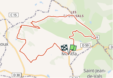
Trail On foot of 12.2 km to be discovered at Occitania, Tarn, Montfa. This trail is proposed by tercla.

Elevation profile

Positioning

Country:
France
Region :
Occitania
Department/Province :
Tarn
Municipality :
Montfa
Location:
Unknown
Start:(UTM)
438947 ; 4838558 (31T) N.

Trails nearby

Trail Walking Roquecourbe - Roquecourbe Lacrouzette - Photo
Walking
Frayssinet

Walking

Medium
Roquecourbe, Occitania, Tarn, France
27 km | 38 km-effort
8h 12min
Yes
Trail Walking Roquecourbe - boucle Roquecourbe  - Photo
Walking
jp.puech

Walking

Very easy
(1)
Roquecourbe, Occitania, Tarn, France
11.1 km | 14.2 km-effort
2h 54min
No
Trail Walking Montfa - 81_Montfa_long_projet - Photo
Walking
jab31

Walking

Easy
Montfa, Occitania, Tarn, France
16.8 km | 22 km-effort
2h 50min
Yes
Trail On foot Roquecourbe - LES HAUTEURS DE ROQUECOURBE - Photo
On foot
CANON2

On foot

Easy
Roquecourbe, Occitania, Tarn, France
11.5 km | 14.7 km-effort
3h 20min
Yes
Trail Walking Montredon-Labessonnié - roquecourbe  - Photo
Walking
chris recht

Walking

Very easy
Montredon-Labessonnié, Occitania, Tarn, France
11 m | 0 m-effort
10h 55min
No
Trail Walking Montfa - 81_Montfa - Photo
Walking
jab31

Walking

Easy
Montfa, Occitania, Tarn, France
12 km | 14.9 km-effort
2h 50min
Yes
Trail Motorbike Montredon-Labessonnié - Rando gr de haut languedoc  - Photo
Motorbike
ktmetarn

Motorbike

Very easy
Montredon-Labessonnié, Occitania, Tarn, France
107 km | 143 km-effort
3h 31min
No
Trail Walking Montredon-Labessonnié - lacazalié 3 - Photo
Walking
michelalard

Walking

Medium
Montredon-Labessonnié, Occitania, Tarn, France
2.6 km | 4.6 km-effort
1h 2min
Yes
Trail Walking Roquecourbe - La plane sur - Photo
Walking
kosnico

Walking

Roquecourbe, Occitania, Tarn, France
9.8 km | 12.8 km-effort
3h 0min
Yes


Close
My subscriptions