Trail Bicycle tourism Langenbruck - ADN - Cesenatico Tronçon 7 - Photo
 m.devil
m.devil

User

© OpenStreetMap contributors
Length
Length
61 km
Max alt
Max alt
707 m
Uphill gradient
Uphill gradient
744 m
Km-Effort
Km-Effort  
71 km
Min alt
Min alt
412 m
Downhill gradient
Downhill gradient
746 m
Boucle
Boucle
No
Creation date :
2024-08-21 09:00:34.504
Updated on :
2024-08-28 15:10:23.781

(0 Reviews)

Bicycle tourism
Bicycle tourism
--
Difficulty : Very difficult

Scan this QR Code to open this trail in the SityTrail application

FREE GPS app for hiking

Logo SityTrail SityTrail

IGN / Geographical institutes

Download SityTrail from the App Store Download SityTrail from Google Play

Logo SityTrail SityTrail World

The world is yours!

Download SityTrail from the App Store Download SityTrail from Google Play Download SityTrail on Huawei AppGallery

About

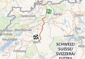
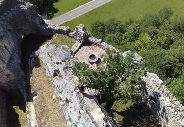
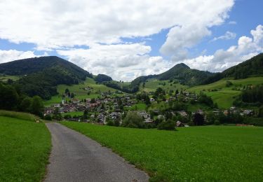
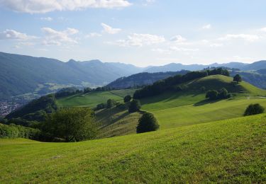
Trail Bicycle tourism of 61 km to be discovered at Basel-Landschaft, Bezirk Waldenburg, Langenbruck. This trail is proposed by m.devil.

Description

Projet

Elevation profile

Points of interest

Positioning

Country:
Switzerland
Region :
Basel-Landschaft
Department/Province :
Bezirk Waldenburg
Municipality :
Langenbruck
Location:
Unknown
Start:(UTM)
406982 ; 5244619 (32T) N.

Trails nearby

Trail On foot Hauenstein-Ifenthal - Challhöchi - Ober Belchen - Photo
On foot
GUIDE+

On foot

Easy
Hauenstein-Ifenthal, Solothurn, Bezirk Gösgen, Switzerland
3.1 km | 4.8 km-effort
1h 5min
No
Trail On foot Egerkingen - Egerkingen - Hägendorf - Photo
On foot
GUIDE+

On foot

Easy
Egerkingen, Solothurn, Bezirk Gäu, Switzerland
4.4 km | 5.9 km-effort
1h 21min
No
Trail On foot Egerkingen - Egerkingen Bahnhof - Fulenbach - Photo
On foot
GUIDE+

On foot

Easy
Egerkingen, Solothurn, Bezirk Gäu, Switzerland
6.6 km | 7.3 km-effort
1h 39min
No
Trail On foot Hauenstein-Ifenthal - Challhöchi - Hauenstein - Photo
On foot
GUIDE+

On foot

Easy
Hauenstein-Ifenthal, Solothurn, Bezirk Gösgen, Switzerland
3.3 km | 4.3 km-effort
59min
No
Trail On foot Holderbank (SO) - Bereten Linde - Holderbank - Photo
On foot
GUIDE+

On foot

Easy
Holderbank (SO), Solothurn, Bezirk Thal, Switzerland
4.5 km | 6 km-effort
1h 21min
No
Trail On foot Holderbank (SO) - Bereten Linde - fixme - Photo
On foot
GUIDE+

On foot

Easy
Holderbank (SO), Solothurn, Bezirk Thal, Switzerland
4 km | 5.5 km-effort
1h 14min
No
Trail On foot Balsthal - St. Wolfgang - Langenbruck - Photo
On foot
GUIDE+

On foot

Easy
Balsthal, Solothurn, Bezirk Thal, Switzerland
6.5 km | 10.3 km-effort
2h 20min
No
Trail On foot Holderbank (SO) - Bereten Linde - Holderbank - Photo
On foot
GUIDE+

On foot

Easy
Holderbank (SO), Solothurn, Bezirk Thal, Switzerland
3.8 km | 4.6 km-effort
1h 2min
No
Trail On foot Langenbruck - Langenbruck - Helfenberg - Photo
On foot
GUIDE+

On foot

Easy
Langenbruck, Basel-Landschaft, Bezirk Waldenburg, Switzerland
3.8 km | 6.7 km-effort
1h 31min
No


Close
My subscriptions