Trail Bicycle tourism Neuf-Brisach - ADN - Cesenatico Tronçon 6 - Photo

ADN - Cesenatico Tronçon 6

 m.devil
m.devil

User

© OpenStreetMap contributors
Length
Length
96 km
Max alt
Max alt
740 m
Uphill gradient
Uphill gradient
1031 m
Km-Effort
Km-Effort  
109 km
Min alt
Min alt
188 m
Downhill gradient
Downhill gradient
521 m
Boucle
Boucle
No
Creation date :
2024-08-21 09:00:34.377
Updated on :
2024-08-28 06:49:58.968

(0 Reviews)

Bicycle tourism
Bicycle tourism
--
Difficulty : Very difficult

Scan this QR Code to open this trail in the SityTrail application

FREE GPS app for hiking

Logo SityTrail SityTrail

IGN / Geographical institutes

Download SityTrail from the App Store Download SityTrail from Google Play

Logo SityTrail SityTrail World

The world is yours!

Download SityTrail from the App Store Download SityTrail from Google Play Download SityTrail on Huawei AppGallery

About

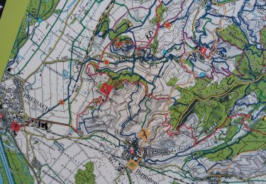
Trail Bicycle tourism of 96 km to be discovered at Grand Est, Haut-Rhin, Neuf-Brisach. This trail is proposed by m.devil.

Description

Projet

Elevation profile

Points of interest

Point of interest Neuf-Brisach - Camping Vauban - Neuf-Brisach - Photo
m.devil

Positioning

Country:
France
Region :
Grand Est
Department/Province :
Haut-Rhin
Municipality :
Neuf-Brisach
Location:
Unknown
Start:(UTM)
390794 ; 5319160 (32U) N.

Trails nearby

Trail Walking Vogelgrun - vogel - Photo
Walking
Marcel Momi

Walking

Difficult
Vogelgrun, Grand Est, Haut-Rhin, France
15.7 km | 17.8 km-effort
20h 19min
Yes
Trail Running Widensolen - Widensolen, un tracé 100% plaisir  - Photo
Running
zazie

Running

Very easy
Widensolen, Grand Est, Haut-Rhin, France
12.1 km | 12.9 km-effort
1h 1min
Yes
Trail Walking Vogelgrun - vogelgrun - Photo
Walking
Marcel Momi

Walking

Difficult
Vogelgrun, Grand Est, Haut-Rhin, France
15.5 km | 17.7 km-effort
4h 8min
Yes
Trail Bicycle tourism Biesheim - ELSASS BIKE 2020 - ETAPE 6 - Photo
Bicycle tourism
Christian Arnold

Bicycle tourism

Easy
Biesheim, Grand Est, Haut-Rhin, France
36 km | 38 km-effort
2h 38min
No
Trail Walking Wolfgantzen - Markstein - Moorfeld - Photo
Walking
jmbilger

Walking

Very easy
Wolfgantzen, Grand Est, Haut-Rhin, France
43 km | 67 km-effort
2h 15min
No
Trail Walking Vogelgrun - ile rhin - Photo
Walking
Hub6877

Walking

Medium
Vogelgrun, Grand Est, Haut-Rhin, France
7.4 km | 8.3 km-effort
2h 27min
Yes
Trail Walking Vogelgrun - vogelgrun - Photo
Walking
Marcel Momi

Walking

Very difficult
Vogelgrun, Grand Est, Haut-Rhin, France
17.1 km | 19.4 km-effort
4h 59min
Yes
Trail Walking Vogelgrun - vog - Photo
Walking
Marcel Momi

Walking

Difficult
Vogelgrun, Grand Est, Haut-Rhin, France
16.2 km | 18.1 km-effort
3h 47min
Yes
Trail Walking Vogelgrun - vogelgrun - Photo
Walking
Marcel Momi

Walking

Difficult
Vogelgrun, Grand Est, Haut-Rhin, France
12.7 km | 14.5 km-effort
3h 9min
Yes


Close
My subscriptions