![](/images/other/stat-length.png)
![Trail Walking Saint-Projet-de-Salers - Col de Légal puy de Chavaroche - Photo](https://media.geolcdn.com/t/1900/400/f9dc9d20-5b8f-465f-9704-8a80b10f246f.jpg&format=pjpeg&maxdim=2)
Col de Légal puy de Chavaroche
antignacs
User GUIDE
![Length](/images/other/stat-length.png)
Length
14.6 km
![Max alt](https://static1.geolcdn.com/siteimages/upload/files/1508320355ic_sort_altitude_max_24dp.png)
Max alt
1729 m
![Uphill gradient](https://static1.geolcdn.com/siteimages/upload/files/1508320355ic_sort_den_pos_24dp.png)
Uphill gradient
755 m
![Km-Effort](/images/other/stat-length.png)
Km-Effort
25 km
![Min alt](https://static1.geolcdn.com/siteimages/upload/files/1508320355ic_sort_altitude_min_24dp.png)
Min alt
1228 m
![Downhill gradient](https://static1.geolcdn.com/siteimages/upload/files/1508320355ic_sort_den_neg_24dp.png)
Downhill gradient
752 m
![Boucle](https://static1.geolcdn.com/siteimages/upload/files/16400158638029165_repeat_loop_refresh_sync_direction_icon.png)
Boucle
Yes
Creation date :
2024-08-20 07:00:01.0
Updated on :
2024-08-25 05:48:53.459
![Walking](https://static1.geolcdn.com/sitytour/trail-icons/101.png)
5h33
Difficulty : Medium
![Scan this QR Code to open this trail in the SityTrail application](https://capi.geolives.com/qq0zvz2zws4bq2lad0pu/sitytour/trails/4162113/qr.png?size=200)
FREE GPS app for hiking
About
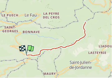
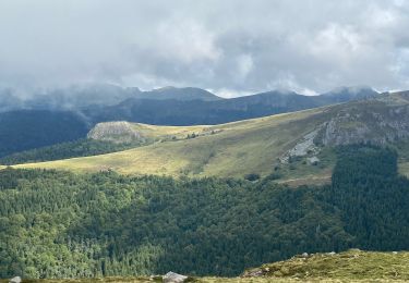
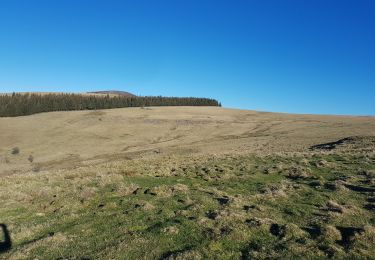
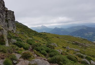
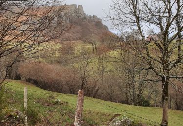
Trail Walking of 14.6 km to be discovered at Auvergne-Rhône-Alpes, Cantal, Saint-Projet-de-Salers. This trail is proposed by antignacs.
Description
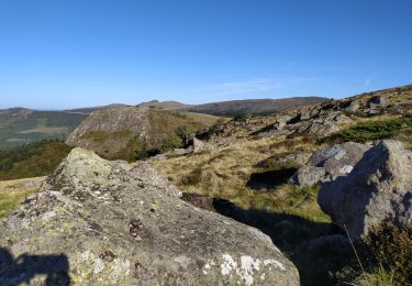
Magnifique d’un bout à l’autre, c’est un aller retour, mais les vues sont splendides dans les deux sens. Ceci économise aussi 300 m de dénivelé par rapport Mandailles et il en reste quand même plus de 700.
Positioning
Country:
France
Region :
Auvergne-Rhône-Alpes
Department/Province :
Cantal
Municipality :
Saint-Projet-de-Salers
Location:
Unknown
Start:(Dec)
Start:(UTM)
466894 ; 4990881 (31T) N.
Comments
Trails nearby
![Trail Hybrid bike Mandailles-Saint-Julien - Tournemire - Photo](https://media.geolcdn.com/t/375/260/e14f03b2-11fc-4b1e-a416-809203cb4d66.jpg&format=jpg&maxdim=2)
![Hybrid bike Hybrid bike](https://static1.geolcdn.com/sitytour/trail-icons/203.png)
Tournemire
Hybrid bike
Medium
Mandailles-Saint-Julien,
Auvergne-Rhône-Alpes,
Cantal,
France
![](/images/other/stat-length.png)
39 km | 50 km-effort
3h 2min
![](https://static1.geolcdn.com/siteimages/upload/files/16400158638029165_repeat_loop_refresh_sync_direction_icon.png)
No
![Trail On foot Saint-Cirgues-de-Jordanne - Le Chaumeil - Photo](https://media.geolcdn.com/t/375/260/53ff843e-c80c-4472-b970-b0e67f3b101f.jpeg&format=jpg&maxdim=2)
![On foot On foot](https://static1.geolcdn.com/sitytour/trail-icons/100.png)
Le Chaumeil
On foot
Easy
Saint-Cirgues-de-Jordanne,
Auvergne-Rhône-Alpes,
Cantal,
France
![](/images/other/stat-length.png)
8.2 km | 13.3 km-effort
3h 0min
![](https://static1.geolcdn.com/siteimages/upload/files/16400158638029165_repeat_loop_refresh_sync_direction_icon.png)
Yes
![Trail On foot Saint-Projet-de-Salers - Sur la route des transhumances étape 3 - Photo](https://media.geolcdn.com/t/375/260/141d518b-0ab0-4b07-be2a-c028168276ab.jpeg&format=jpg&maxdim=2)
![On foot On foot](https://static1.geolcdn.com/sitytour/trail-icons/100.png)
Sur la route des transhumances étape 3
On foot
Easy
Saint-Projet-de-Salers,
Auvergne-Rhône-Alpes,
Cantal,
France
![](/images/other/stat-length.png)
12.4 km | 17.9 km-effort
4h 3min
![](https://static1.geolcdn.com/siteimages/upload/files/16400158638029165_repeat_loop_refresh_sync_direction_icon.png)
No
![Trail Walking Le Fau - Puy violent - Photo](https://media.geolcdn.com/t/375/260/abb730dc-c4ed-4c8e-b196-15e705b50c2c.jpg&format=jpg&maxdim=2)
![Walking Walking](https://static1.geolcdn.com/sitytour/trail-icons/101.png)
Puy violent
Walking
Very difficult
Le Fau,
Auvergne-Rhône-Alpes,
Cantal,
France
![](/images/other/stat-length.png)
22 km | 37 km-effort
8h 29min
![](https://static1.geolcdn.com/siteimages/upload/files/16400158638029165_repeat_loop_refresh_sync_direction_icon.png)
Yes
![Trail Walking Saint-Projet-de-Salers - Col de Legal Cabrespine - Photo](https://media.geolcdn.com/t/375/260/7f51507d-5662-47ed-9e4c-8dfe19c46db4.jpg&format=jpg&maxdim=2)
![Walking Walking](https://static1.geolcdn.com/sitytour/trail-icons/101.png)
Col de Legal Cabrespine
Walking
Very easy
Saint-Projet-de-Salers,
Auvergne-Rhône-Alpes,
Cantal,
France
![](/images/other/stat-length.png)
8.2 km | 13.6 km-effort
2h 43min
![](https://static1.geolcdn.com/siteimages/upload/files/16400158638029165_repeat_loop_refresh_sync_direction_icon.png)
Yes
![Trail Walking Laroquevieille - col du bruel - Photo](https://media.geolcdn.com/t/375/260/d47dbd1d-15d2-46f9-87a2-ab30b3adeb21.jpg&format=jpg&maxdim=2)
![Walking Walking](https://static1.geolcdn.com/sitytour/trail-icons/101.png)
col du bruel
Walking
Medium
Laroquevieille,
Auvergne-Rhône-Alpes,
Cantal,
France
![](/images/other/stat-length.png)
10.1 km | 15.2 km-effort
2h 38min
![](https://static1.geolcdn.com/siteimages/upload/files/16400158638029165_repeat_loop_refresh_sync_direction_icon.png)
Yes
![Trail Walking Saint-Projet-de-Salers - Col de Legal vers le Puy de Chavaroche - Photo](https://media.geolcdn.com/t/375/260/0829545a-1240-4ba6-8f6f-7c954f785d42.jpg&format=jpg&maxdim=2)
![Walking Walking](https://static1.geolcdn.com/sitytour/trail-icons/101.png)
Col de Legal vers le Puy de Chavaroche
Walking
Medium
Saint-Projet-de-Salers,
Auvergne-Rhône-Alpes,
Cantal,
France
![](/images/other/stat-length.png)
8.5 km | 13.8 km-effort
3h 8min
![](https://static1.geolcdn.com/siteimages/upload/files/16400158638029165_repeat_loop_refresh_sync_direction_icon.png)
Yes
![Trail Walking Mandailles-Saint-Julien - Roches folles - Photo](https://media.geolcdn.com/t/375/260/8984fadf-4f9b-4d7e-9bc1-4440944bdfaa.jpg&format=jpg&maxdim=2)
![Walking Walking](https://static1.geolcdn.com/sitytour/trail-icons/101.png)
Roches folles
Walking
Very easy
Mandailles-Saint-Julien,
Auvergne-Rhône-Alpes,
Cantal,
France
![](/images/other/stat-length.png)
7 km | 11.1 km-effort
2h 20min
![](https://static1.geolcdn.com/siteimages/upload/files/16400158638029165_repeat_loop_refresh_sync_direction_icon.png)
Yes
![Trail Walking Saint-Cirgues-de-Jordanne - La Flandonnière - Photo](https://media.geolcdn.com/t/375/260/ext.jpg?maxdim=2&url=https%3A%2F%2Fstatic1.geolcdn.com%2Fsiteimages%2Fupload%2Ffiles%2F1553511878bg_sport_marche.png)
![Walking Walking](https://static1.geolcdn.com/sitytour/trail-icons/101.png)
La Flandonnière
Walking
Easy
(1)
Saint-Cirgues-de-Jordanne,
Auvergne-Rhône-Alpes,
Cantal,
France
![](/images/other/stat-length.png)
7.6 km | 11.3 km-effort
2h 19min
![](https://static1.geolcdn.com/siteimages/upload/files/16400158638029165_repeat_loop_refresh_sync_direction_icon.png)
Yes