Trail Canoe - kayak Caluire-et-Cuire - Descente Saone Bocuse Perrache - Photo
 lulu7469
lulu7469

User

© OpenStreetMap contributors
Length
Length
9.4 km
Max alt
Max alt
174 m
Uphill gradient
Uphill gradient
8 m
Km-Effort
Km-Effort  
9.5 km
Min alt
Min alt
165 m
Downhill gradient
Downhill gradient
8 m
Boucle
Boucle
No
Creation date :
2024-08-17 11:44:49.629
Updated on :
2024-08-17 12:01:04.384

(0 Reviews)

Canoe - kayak
Canoe - kayak
0m
Difficulty : Easy

Scan this QR Code to open this trail in the SityTrail application

FREE GPS app for hiking

Logo SityTrail SityTrail

IGN / Geographical institutes

Download SityTrail from the App Store Download SityTrail from Google Play

Logo SityTrail SityTrail World

The world is yours!

Download SityTrail from the App Store Download SityTrail from Google Play Download SityTrail on Huawei AppGallery

About

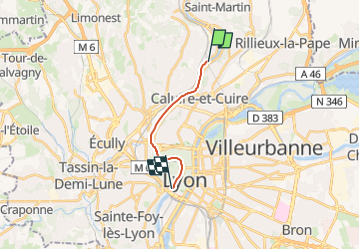
Trail Canoe - kayak of 9.4 km to be discovered at Auvergne-Rhône-Alpes, Métropole de Lyon, Caluire-et-Cuire. This trail is proposed by lulu7469.

Description

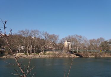
Descente la Saone de Bocuse à Perrache

2 heures de descente

Elevation profile

Positioning

Country:
France
Region :
Auvergne-Rhône-Alpes
Department/Province :
Métropole de Lyon
Municipality :
Caluire-et-Cuire
Location:
Unknown
Start:(UTM)
643590 ; 5075099 (31T) N.

Trails nearby

Trail Walking Couzon-au-Mont-d'Or - Tour de Couzon par les crêtes - Photo
Walking
boivin101

Walking

Difficult
(2)
Couzon-au-Mont-d'Or, Auvergne-Rhône-Alpes, Métropole de Lyon, France
6.5 km | 10.7 km-effort
2h 5min
Yes
Trail Mountain bike Collonges-au-Mont-d'Or - Tour du Mont Cindre et Mont Thoux - Photo
Mountain bike
tracegps

Mountain bike

Difficult
(3)
Collonges-au-Mont-d'Or, Auvergne-Rhône-Alpes, Métropole de Lyon, France
25 km | 33 km-effort
1h 40min
Yes
Trail Walking Lyon - Croix-Rousse / la Tête d'Or  - Photo
Walking
GUIDE
VANDERPUTTENMi

Walking

Very easy
Lyon, Auvergne-Rhône-Alpes, Métropole de Lyon, France
8.8 km | 10.2 km-effort
2h 23min
No
Trail Walking Caluire-et-Cuire - A_CALUIRE 69300 St-Clair - Crépieux - Photo
Walking
ANDREJAC

Walking

Easy
(1)
Caluire-et-Cuire, Auvergne-Rhône-Alpes, Métropole de Lyon, France
10 km | 11.7 km-effort
3h 0min
Yes
Trail Walking Couzon-au-Mont-d'Or - A_COUZON AU MT D'OR 69270  Croix Vitaise - Mont Thoux - Photo
Walking
ANDREJAC

Walking

Medium
(2)
Couzon-au-Mont-d'Or, Auvergne-Rhône-Alpes, Métropole de Lyon, France
8.5 km | 13.6 km-effort
3h 0min
Yes
Trail Mountain bike Lyon - Monts d'Or_02 - Photo
Mountain bike
philmascio

Mountain bike

Medium
(2)
Lyon, Auvergne-Rhône-Alpes, Métropole de Lyon, France
32 km | 45 km-effort
2h 54min
Yes
Trail Mountain bike Fontaines-sur-Saône - Rando de la Madone de Fleurieu sur Saône - Photo
Mountain bike
tracegps

Mountain bike

Medium
(1)
Fontaines-sur-Saône, Auvergne-Rhône-Alpes, Métropole de Lyon, France
24 km | 30 km-effort
2h 30min
Yes
Trail Walking Saint-Cyr-au-Mont-d'Or - s3-c_st_cyr_69450_3d_homme_paysage - Photo
Walking
vidal.galaxy

Walking

Medium
(1)
Saint-Cyr-au-Mont-d'Or, Auvergne-Rhône-Alpes, Métropole de Lyon, France
6.6 km | 9.3 km-effort
2h 6min
Yes
Trail Walking Lyon - cuire et ile barbe - Photo
Walking
maclobar

Walking

Very difficult
Lyon, Auvergne-Rhône-Alpes, Métropole de Lyon, France
17.8 km | 23 km-effort
5h 16min
No


Close
My subscriptions